
Västgötabergen

Västgötabergen is the Swedish name for a chain of, depending on the number, 13 to 17 stratified mountains surrounding the Västgöta plain (Swedish Västgötaslätten ). The plain is geographically largely identical to the northern part of the historic province of Västergötland and actually consists of several separate stages that stretch between the lakes Vänern in the north-west, Vättern in the north-east and the southern Swedish highlands in the south.
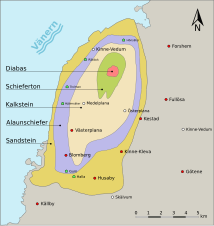
The highest peaks are in the so-called Falbygden , an old cultural landscape in western Sweden , which is sometimes called "Falan" after the high plateau between the cities of Skövde and Falköping . You reach in Ålleberg near Falköping at 330 m above sea level. NN its highest point. As a geological formation , the area belongs to the Central Swedish Depression .
Emergence


The mountains consist of a sequence of layers of sedimentary rocks that were deposited in the geological periods Precambrian , Cambrian , Ordovician and Silurian over 140 million years.
In the subsequent Permian geological age , magma penetrated up through cracks in the rock and covered the sediments with a cover layer of diabase .
When the area was raised during the Caledonian Orogeny at the end of the Silurian Mountains, it was no longer below sea level, but the layers under the diabase cover were protected from erosion . In the contact area with the magma, which sometimes extends down to 25 meters, the original rock was additionally hardened ( fritted ) and therefore particularly solid. All around, the softer unprotected rock was removed, while the current stepped shape of the mountains remained. Their summit plateaus rise on average about 100 meters above the surrounding plains.
For the geologist, the structure of the table mountains is like a walk-in history book that describes the past 500 million years. The sequence of layers can be illustrated particularly well using the example of the Kinnekulle .
The layers in detail:
Basement
Since the Västgöta plain is actually a stratified landscape, the bedrocks are different depending on the height.
The bedrock in Falbygden, around Kinnekulle and Billingen was formed between 1700 and 1670 mya and consists of granite and tonalite , which often occur together and in banded form .
In the area around Halleberg and Hunneberg , the basement was formed in a similar period of time, but about 100 million years earlier, i.e. before 1600 to 1560 mya. It consists of granite, gneiss and tonalite, which also often come to light in a band.
At that time, Västergötland lay in the hypothetical supercontinent of Columbia, deep below sea level at the foot of a large mountain range. Life was limited to simply built bacteria and unicellular organisms.
During the cryogenium before 850 to 635 mya there were several global ice ages, each of which led to an approximately global icing of the earth. The bedrock was removed so much by the activity of the glaciers that a rump area landscape (peneplain, almost plain) was created.
A rapid increase in the concentration of carbon dioxide in the atmosphere, caused by strong volcanic activity, caused a greenhouse effect about 543 million years ago that ended the Ice Ages. It is the beginning of the Cambrian species explosion , as a result of which life evolved from the simplest forms to plants and animals with limbs, double DNA helixes and sexual fertilization.
Sandstone
Towards the end of the Precambrian 530 million years ago, Västergötland was on the continent of Baltica . The present area was covered by a shallow sea and over the bedrock, eroded rock material up to the Cambrian was deposited as thick layers of sand that solidified into sandstone over time. In this thick on average more than 25 meters of rock layer fossil find of cephalopods (cephalopods), Archaeocyaths , brachiopods (brachiopods), trilobites , graptolites , corals and ostracods (ostracods). In the uppermost layers the first nautiloid ideas , the cephalopod family that has survived to this day.
Alum slate
Sea levels rose in the Middle Cambrian and the beginning of the Ordovician 515 to 485 mya due to the increasing temperatures, which also melted the polar ice caps. A self-reinforcing process had started. Thanks to the heat, the total biomass increased. However, because the habitat of the flora and fauna of the Cambrian was limited to the seas, the oxygen content steadily decreased there. If organic material sank to the ground after it had died, it was only incompletely decomposed. Favored by coalification , a layer of digested sludge (sapropel) was created, which was then converted over long periods of time to an average of 25 meters thick bituminous alum slate layer .
In addition, certain anaerobic bacteria in the mud , which are bound to a life without oxygen, caused the sulphate to be converted to hydrogen sulphide . Through this, sulfate-reducing bacteria process mentioned could in seawater dissolved heavy metals as sulphides , such as pyrite (FeS 2 ) or Urandisulfid (US 2 ), precipitated are and stored in the sediment.
This explains why the area's alum slate contains both oil shale and uranium. The rock was formerly mined and used as fuel for burning lime in many limestone quarries in Västergötland. Nowadays it is used for the extraction of uranium and thus as a fuel in nuclear reactors . At Ranstad, south of the Billingen, is Sweden's largest uranium deposit with a uranium content of 254,000 t.
In the alum slate there are many layers of anthraconite , a calcite colored black by charcoal, which is locally called Orsten or English stinkstone because it gives off an unpleasant odor when it is processed.
The sedimentary rock is also rich in fossils . Examples of fossilized organisms include A. microscopic, unicellular algae and acritarcha that dominated the flora of the Cambrian. Land plants had not yet developed.
annotation
- ↑ In geological terms, activation means the storage of a rock layer in another, predominant rock layer.
limestone
The limestone was formed in the Middle Cambrian and Ordovician 513 to 470 mya. The sea had become deeper and was dominated by marine life, which in the warm environment was able to develop the load-bearing structures of their bodies with the help of the calcite dissolved in the water without using much energy . Coccolithophorida and foraminifera in particular contributed significantly to the formation of the limestone layer. At that time, these rock-forming organisms removed most of the atmospheric carbon dioxide that had previously been emitted by volcanoes at the beginning of the Cambrian. At the same time, the oxygen content in the atmosphere increased and the basis for modern, aerobic life forms was created. When they sank to the seabed after their death, the so-called coccolith sludge was created, which was subsequently completely sedimented by diagenesis . The carbon in the limestone of the sediment remained permanently chemically bound. In addition to the microorganisms, which can hardly be differentiated from microscopic mineral grains from precipitated calcite, there are shell remains of trilobites, echinoderms and straight horns (Orthocerida) in the rock layer, above which only poor, less fertile soils develop. Therefore the area around Falbygden is more suitable for grazing than for agricultural cultivation.
Slate
During several periods in the late Cambrian and early Silurian before 500 to 430 mya, the weathering material of the continents was gradually deposited as fine mud in the deeper sea zones. This clay mud was mainly formed by the chemical decomposition of feldspar , quartz and mica . So-called clay minerals such as kaolin and organic and bituminous components were also added. The sedimentation of the sludge resulted in shale clay. Contrary to what the suspect as a name, it is not to "real" slate because the rock no metamorphic was subjected to recrystallization, so no features of the foliation has.
A gradual transformation into metamorphic clay slate could only have taken place under increased pressure in deeper layers of the earth's crust. Fossils would have been destroyed in this process.
The clay sludge solidified, however, purely diagenetically, there was no mineral conversion and therefore brachiopods , trilobites and various plants were preserved as fossils. One speaks therefore of an "undeformed slate". The mica alone is responsible for the schisty, somewhat leafy structure of the sediment. (see linkage of layers in mica )
This type of rock is called “Lerskiffer” in Swedish, meaning clay slate. In German usage, however, this is the name for the material that is processed into roof tiles and panels. Slate is far too soft for this use. If it continues to erode, it will further improve the fertile clay soils of the Vara Plain.
Diabase
When the continents of the earth collided at the end of the Permian 300 to 270 million years ago and formed the supercontinent Pangea , a geologically very interesting time began. It is characterized by geologically significant events that do not necessarily have to be directly related, but the approximate coincidence of the events is seen as an indication of a causal connection. During the great mass extinction on the Permian-Triassic border , 90% of all living things on earth died out. At about the same time, huge volcanic eruptions took place and large amounts of basaltic lava covered an extensive area of prehistoric Siberia , creating the two million square kilometers Siberian Trapp .
In Västergötland, too, the surface rock fractured in several places and magma rose up along the fault lines. In Falbygden, the area around the Billingen and the Kinnekulle, the magma penetrated into cracks in the uppermost layers of the Silurian and, after cooling, solidified as a hard blanket of flood basalt . The intruded rock body is called laccolith and subsequently protected the rock layers below from erosion.
On the Halleberg and Hunneberg, however, the lava could only penetrate into older Cambrian and Ordovician layers and formed a so-called storage corridor . The overlying limestone and slate layers were not given a diabase cover and were exposed to wind and weather without protection. The Halleberg and Hunneberg were therefore removed down to the bottom two layers and the diabase layer above and are consequently lower than the other mountains in the region. The top layer on Halleberg and Hunneberg has an average thickness of 60 meters.
Diabase is called “Trapp = stairs” in Swedish and is the name given to the geological term of the same name .
Schematic representation of the layers

Rock layers in profile and top view 1)
( 1) = only Kinnekulle)
.svg&lang=de)

List of table mountains in Västergötland


_i_Tidaholms_kommun,_den_25_aug_2006.JPG)

_i_Tidaholms_kommun,_den_25_aug_2006.JPG)


Individual evidence
- ↑ a b c d e Reinhard Kleßen, Matthias Ley (Ed.): Excursion to Sweden, page 51 ff. PDF, 13 MB
- ↑ a b c Halle Hunneberg, the geology of the mountains
- ^ Douglas H. Underhill: Analysis of uranium supply to 2050. In: International Atomic Energy Agency. Vienna 2001.
- ↑ http://www.mantleplumes.org/Siberia.html Gerald K. Czamanske and Valeri A. Fedorenko: The Demise of the Siberian Plume , Jan. 2004
-
↑ a b c Height and area data were taken from the maps provided by the Swedish Provincial Administration. Information on municipalities refer to the associated district, on which the largest part of the respective mountain is located. If there are several possible locations, they are sorted in alphabetical order.
Example: Map section for the Angertuvan , alternative display ( Silverlight web application)