South Swedish highlands
| South Swedish highlands | ||
|---|---|---|
|
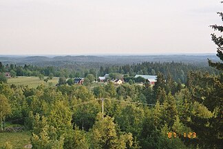
View over the highlands of Tomtabacken from |
||
| Highest peak | Tomtabacken ( 377 m above sea level ) | |
| location | Europe :; Sweden | |
|
|
||
| Coordinates | 56 ° 59 ′ N , 14 ° 33 ′ E | |
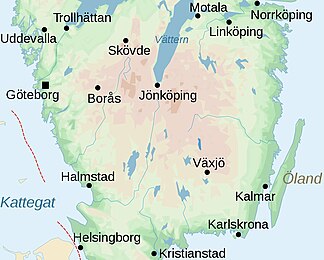
The southern Swedish highlands , often just the Småland highlands , are only roughly defined highlands in southern and central Sweden. It includes the region of northern Småland, southern Östergötland and southern and eastern Västergötland , which is over 200 meters above sea level. lies.
The highest mountains are next to Tomtabacken with 377 meters, Galtåsen with 361 meters, Taberg with 343 meters and Stenabohöjden with 328 meters above sea level.
The highlands were created in the course of an uplift in the Tertiary .
topography
Most of the southern Swedish highlands are in Småland. This very mountainous and hilly part is also called the "Highlands of Småland" . It includes parts of the municipalities of Aneby , Eksjö , Nässjö , Sävsjö , Tranås and Vetlanda , all of which are in the eastern part of Jönköpings län . In Väster- and Östergötland it goes into the central Swedish depression .
flora
The area is almost completely forested and characterized by moors .
climate
Due to westerly pressure winds in the highlands, there are significantly more rain and thunderstorms than in the surrounding areas. The air, especially the refractive index of radio waves , has strong seasonal fluctuations, mainly due to the combination of temperature, pressure and humidity.
Cultural history
The southern Swedish highlands were already populated in the Paleolithic . Back then, people lived almost exclusively from hunting and gathering . From the Neolithic Age , people in this region settled down and practiced agriculture . Traces of agriculture as well as of settlements and roads are from almost all prehistoric epochs, u. a. also the Bronze and Iron Ages , preserved and preserved in the soils, mainly in untouched areas of land such as forests. Burial mounds and stone circles from the Bronze and Iron Ages can also be found all over the highlands.
The iron ore deposits found in the early Iron Age became increasingly important from the 17th century. From this time on, the rather poor soil was no longer sufficient to adequately feed the growing population, so that iron ore mining was accelerated more and more and smaller industrial companies such as foundries and forges emerged. Coal piles, mines and other finds bear witness to the fact that iron production in this region is several thousand years old. In the centuries that followed, iron mining remained very important in the southern Swedish highlands and promoted Swedish industrialization.
Trivia
- Not far from the village of Ingatorp , in the Småland highlands, is the tenth hut by Ingatorp, built in 1229 - with over 780 years the oldest surviving wooden house in Sweden.
Individual evidence
- ↑ a b Short definition of the southern Swedish highlands (Swedish) , ne.se, accessed on October 26, 2010
- ↑ Geomorfology of the Västra Götaländisches Landesteil Sjuhäradsbygden (Swedish) ( Memento of the original from September 28, 2007 in the Internet Archive ) Info: The archive link has been inserted automatically and has not yet been checked. Please check the original and archive link according to the instructions and then remove this notice. , friatlasgis.sna.se, accessed October 26, 2010
- ↑ a b c Overview of cultural history (Swedish) , svo.se, accessed on October 26, 2010
- ↑ a b Brief cultural history of the region (Swedish) , skogforsk.se, accessed on October 26, 2010
- ↑ Sweden's oldest wooden house is in Småland! , bock-schroeder.de, accessed on October 26, 2010


