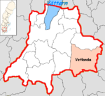
Vetlanda (Municipality)
| Vetlanda municipality | |||||
|---|---|---|---|---|---|
|
|||||
| State : | Sweden | ||||
| Province (län): | Jönköpings län | ||||
| Historical Province (landskap): | Småland | ||||
| Main place: | Vetlanda | ||||
| SCB code: | 0685 | ||||
| Residents : | 27,466 (December 31, 2019) | ||||
| Area : | 1,600.4 km² (January 1, 2016) | ||||
| Population density : | 17.2 inhabitants / km² | ||||
| Website : | www.vetlanda.se | ||||
| List of municipalities in Sweden | |||||
Coordinates: 57 ° 26 ′ N , 15 ° 5 ′ O Vetlanda is a municipality ( Swedish commun ) in the Swedish province of Jönköpings län and the historic province of Småland . The main town of the municipality is Vetlanda .
geography
The municipality of Vetlanda is the largest municipality in the province of Jönköpings län and the distances to the three largest Swedish cities Stockholm , Gothenburg and Malmö are all around 300 kilometers.
coat of arms
Description: In gold, a blue diagonal bar covered with a golden ear of corn.
places
The following eleven places are localities ( tatorter ) of the municipality of Vetlanda:
- Björköby
- Ekenässjön
- Holsbybrunn
- Korsberga
- Kvillsfors
- Landsbro
- Myresjö
- Paulistrom
- Sjunnen
- Skede
- Vetlanda (main town)
Attractions
To the west of Vetlanda on the southern bank of the Norrasjön are the ruins of Hultaby Castle, which date back to the Middle Ages . The Kleva gruva mine is located near Holsbybrunn . The Levanders Lanthandel store, which is run as a museum, is located in Alseda .
Personalities
Web links
- Official website (Swedish)
swell
- ↑ Folkmängd i riket, län och kommuner December 31, 2019 at Statistiska centralbyrån
- ↑ Kommunarealer January 1, 2016 at Statistiska centralbyrån (including all inland waters)

