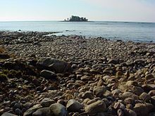
Vänern
| Vänern | ||
|---|---|---|

|
||
| Map of the Vänern | ||
| Geographical location | Sweden | |
| Tributaries | Klarälven , Gullspångsälven , Alsterälven , Borgviksälven , Byälven , Dalbergså , Lidan , Norsälven , Upperudsälven , Tidan | |
| Drain | Göta älv | |
| Places on the shore | Karlstad , Kristinehamn , Lidköping , Mariestad , Vänersborg , Åmål | |
| Location close to the shore | Säffle , Trollhättan | |
| Data | ||
| Coordinates | 58 ° 48 ' N , 13 ° 20' E | |
|
|
||
| Altitude above sea level | 44.4 m above sea level | |
| surface | 5 519.1 km² | |
| length | 150 km | |
| width | 81 km | |
| volume | 153 km³ | |
| scope | 1790 km | |
| Maximum depth | 106 m | |
| Middle deep | 27 m | |
| Catchment area | 47,000 km² | |
|
particularities |
largest lake in Scandinavia |
|
Vänern ( German also Vänersee , formerly Wenersee ) is a lake in the southwest of Sweden , located between the historic provinces of Dalsland , Värmland and Västergötland . With an area of 5,519.1 km², it is the largest lake in the country, the largest in the European Union and the third largest lake in Europe after Lake Ladoga and Lake Onega (both located in Russia ) .
During the last ice age , the Vänern was in contact with the sea, which has an impact on its flora and fauna to this day , e. B. Occurrence of marine life in fresh water . 35 different types of fish live in it. It owes its topography to the post-glacial land elevation .
geography
The Vänern is 44 meters above sea level and has an average depth of 27 m; its greatest depth is 106 m. It has a volume of 153 km³ and its coastline is about 2000 km.
The lake is divided into a western and an eastern part by a sound between the Värmlandsnäs peninsula and the island of Kållandsö . The western part of Vänern is also known as Dalbosjön , the larger eastern part also as Värmlandssjön . The Vänern near Vänersborg drains from the western part over the Göta älv towards the Kattegat .
The largest islands in Vänern are Torsö , (61 km², in front of Mariestad ), Kållandsö (57 km², near Lidköping ) and Hammarö (47 km², near Karlstad ). The lake also has several archipelago gardens , making a total of around 22,000 islands.
The Vänern, together with the Göta älv to Göteborg , which has been upgraded to the Trollhätte Canal , and the Göta Canal across Lake Vättersee towards the Baltic Sea, offer a waterway across Sweden. The Vänern is also connected to the Vättern via the Göta Canal .
Birds
The most common birds near Lake Vänern are terns and gulls of various species. The cormorants disappeared in the 19th century, but have now returned and formed a thriving population.
Nature reserves (selection)
- Djurö National Park
- Kalvö archipelago ( Natura 2000 area)
- Surö nature reserve (Natura 2000 area)
- Nötön-Åråsviken
See also
literature
- Lennart Utgren: Sköna Värmland . Formula Five, Stockholm 2006, ISBN 91-631-8247-5 .
Web links
Individual evidence
- ↑ Sjöareal och sjöhöjd (3.32 MB; PDF) , Svenskt vattenarkiv (SVAR), Sveriges meteorologiska och hydrologiska institut (Swedish)
- ↑ a b Vattenståndsmätningar i Vänern (PDF; 1.5 MB) ( Memento of the original from February 1, 2012 in the Internet Archive ) Info: The archive link was inserted automatically and has not yet been checked. Please check the original and archive link according to the instructions and then remove this notice. , Sveriges meteorologiska och hydrologiska institut (Swedish)
- ↑ a b c Sjödjup och sjövolym (712.6 kB; PDF) , Svenskt vattenarkiv (SVAR), Sveriges meteorologiska och hydrologiska institut (Swedish)
- ↑ Kust och stränder i Sverige (407 kB; PDF) , Statistiska centralbyrån ( http://www.scb.se ) (Swedish)
- ↑ VattenWeb , Sveriges meteorologiska och hydrologiska institut (Swedish)
- ↑ Sveriges riksdag: Fiske i Vänern och Vättern (Swedish)


