Upperudsälven
| Upperudsälven | ||
|
Map of the Upperudsälven river system in dark blue |
||
| Data | ||
| location | Västra Götalands län ( Sweden ) | |
| River system | Göta älv | |
| Drain over | Göta älv → Kattegat | |
| muzzle |
Vänern coordinates: 58 ° 46 ′ 49 " N , 12 ° 31 ′ 28" E 58 ° 46 ′ 49 " N , 12 ° 31 ′ 28" E |
|
| Mouth height |
44.4 m above sea level
|
|
| length | 146 km (including source rivers) | |
| Catchment area | 3336 km² | |
| Outflow at the level at the mouth |
MQ |
45 m³ / s |
| Communities | Håverud | |
|
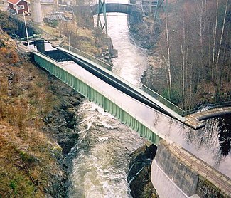
Aqueduct at Håverud |
||
|
Aqueduct at Håverud |
||
The Upperudsälven is a tributary of the Vänern and river system in the Swedish province of Västra Götalands län .
The river system drains an area of 3336 km², a small part of which is also in Norway, and includes the lakes Stora Le and Foxen , Lelång , Västra Silen and Östra Silen .
The river system is navigable through the Dalsland Canal . The total length of the Upperudsälven including source rivers is 146 km.
Individual evidence
- ↑ SMHI - Sjöareal och sjöhöjd (PDF; 3.5 MB)


