
Torneträsk
| Torneträsk | ||
|---|---|---|

|
||
| Geographical location | Kiruna Municipality , Lapland , Sweden | |
| Tributaries | Abiskojåkka | |
| Drain | Torne alv | |
| Places on the shore | Abisko , Björkliden | |
| Data | ||
| Coordinates | 68 ° 19 ′ N , 19 ° 17 ′ E | |
|
||
| Altitude above sea level | 341 m above sea level | |
| surface | 330 km² | |
| volume | 17.1 km³ | |
| Maximum depth | 168 m | |
| Middle deep | 51.8 m | |
| Catchment area | 3380 km² | |

The Torneträsk ( Sami Duortnosjávri , Finnish Torniojärvi ) is a lake in the northern Swedish province of Norrbotten County and the historic province of Lapland . In terms of its area of 330 km², it ranks seventh in Sweden . To the southwest of the lake are the Abisko National Park and the UNESCO natural heritage site Laponia .
The lake is at 341 m above sea level. in a depression created by the ice sheet, it is 70 km long and up to 168 m deep. The Torneträsk is usually covered in ice from December to mid-June, but there are annual fluctuations. The largest tributary is called Abiskojåkka and the outflow is the Torne älv .
To the south of the lake, Europastraße 10 and the ore railway run over large stretches . To the west are the villages of Abisko and Björkliden .
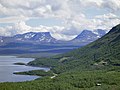
View of parts of Torneträsk, with Lapporten in the background

IORE with an empty ore train at Torneträsk
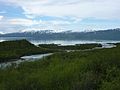
The mouth of the Abiskojåkka at Torneträsk near Abisko


Individual evidence
- ↑ Sjöareal och sjöhöjd (3.32 MB; PDF) , Svenskt vattenarkiv (SVAR), Sveriges meteorologiska och hydrologiska institut (Swedish)
- ↑ a b c Sjödjup och sjövolym (712.6 kB; PDF) , Svenskt vattenarkiv (SVAR), Sveriges meteorologiska och hydrologiska institut (Swedish)
- ↑ VattenWeb , Sveriges meteorologiska och hydrologiska institut (Swedish)