
Abiskojåkka
|
Abiskojåkka Ábeskoeatnu |
||
 |
||
| Data | ||
| location | Abisko National Park in Norrbotten County ( Sweden ) | |
| River system | Torne alv | |
| Drain over | Torne älv → Baltic Sea | |
| 1. Glacier 2. Lake |
1. south of the Válfojávri 2. Ábeskojávri |
|
| Source height |
488 m above sea level (See) 1189 (Glacier) Map server of the Swedish state land surveying system Glacier 68 ° 16 ′ 1.56 ″ N, 18 ° 7 ′ 41.16 ″ E south of the Válfojávri |
|
| muzzle | in the lake Torneträsk Coordinates: 68 ° 21 ′ 50 " N , 18 ° 47 ′ 15" E 68 ° 21 ′ 50 " N , 18 ° 47 ′ 15" E |
|
| Mouth height | 341 m above sea level | |
| Height difference | 147 m | |
| Bottom slope | 15 ‰ | |
| length | 10 km (nominal) 45 km (hydrological) |
|
| Catchment area | 544 km² | |
| Communities | Kiruna | |
The Abiskojåkka ( North Sami Ábeskoeatnu ) is a river in the Abisko National Park in northern Sweden . It is the outlet of the Abiskojaure . After about 10 kilometers it flows into the Torneträsk at Abisko and is its largest tributary. Regionally, the upper section of the Torne älv, which rises from the Torneträsk, is also known as Abiskojåkka, at least as far as Jukkasjärvi . The height of fall from Abiskojaure to Torneträsk is 147 meters. When the snow melts in spring, its water level is several meters higher.
source
The actual origin of the river is 1189 m above sea level and is a small glacial lake in Norway, 0.3 km west of the Swedish border). After about 3 km the glacier stream flows into the Válfojohka, the main tributary of the Swedish lake Gamajávri (610 m above sea level), just below the Norwegian lake Válfojávri (1009 m above sea level in Norway, approx. 1 km west of the Swedish border). Its outflow Gamaeatnu ( Swedish Kamajåkka) is the main tributary of the lake Ábeskojávri ( Swedish Abiskojaure (488 m above sea level), whose outflow Ábeskoeatnu / Abiskojåkka is the main tributary of the lake Duortnosjárvi (Swedish Torneträsk ), the Voss river Gamajávri, Kamajåkka, Abiskojaure and Abiskojåkka together have a length of about 45 km, and in total they drain an area of 544 km².
Abisko kanjon
At Abisko the Abiskojåkka flows through a canyon. The canyon was formed by erosion of the softer rock components.
Abisko delta
A delta has formed at the mouth of the Abiskojåkka and the Torneträsk. It consists of mud and gravel brought by Abiskojåkka. Access to the delta is closed during the bird breeding season from May to July.
Flora and fauna
Abiskojåkka is home to grayling ( Thymallus thymallus ), sea trout ( Salmo trutta ) and char ( Salvelinus ).
Birds in the flow are the throated diver ( Gavia arctica ), the Sterntaucher ( Gavia stellata ), the Temminck ( Calidris temminckii ), the long-tailed ( Clangula hyemalis ) which Trauerente ( Melanitta nigra ), the means sawyer ( Mergus serrator ), the Plover ( Charadrius hiaticula ), various dipper ( Cinclus ), the mountain finch ( Fringilla montifringilla ), the gray flycatcher ( Muscicapa striata ), the bluethroat ( Luscinia svecica ), the yellow wagtail ( Motacilla flava ) and the gray wagtail ( Motacilla cinerea ).
On the shore area and the canyon of growing Astragalus alpinus ( Astragalus alpinus ), the golden root ( Rhodiola rosea ), and various types of Silene ( Silene ) and the Saxifragaceae ( Saxifraga ).
Malmbanan
During the construction of the Malmbanan , a tunnel was blasted for Abiskojåkka near Abisko, as it was easier to lead the river through a tunnel than to build a bridge for the railroad. A former house plot can be seen in the canyon near the Abisko Turiststation. This house was a power station that provided electricity for the construction of the Malmbaban.
Hiking trails
The Kungsleden and the Nordkalottleden follow the course of the Abiskojåkka between the Abisko tourist station and the Abiskojaure hiking hut . There are also several shorter hiking trails along the river at Abisko.
literature
- Anna Burman: Abisko. Turtips (= Länsstyrelsen i Norrbottens Län. Report series. 1, 2003, ISSN 0283-9636 ). Länsstyrelsen i Norrbottens län, Luleå 2003.
- Sverige Lantmäteriverket: Lantmäteriets fjällkarta. BD 6, Abisko - Kebnekaise - Narvik. 3. Edition. Lantmäteriet, Gävle 2006, ISBN 91-588-9488-8 .
Web links
- ↑ GPS track from the source glacier (see map server of the Swedish state land surveying ) to the confluence with the Torneträsk

Abisko kanjon


Abisko kanjon
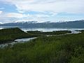
The mouth of the Abiskojåkka at Torneträsk near Abisko


