Tama (Tokyo)
| Tama-shi 多 摩 市 |
||
|---|---|---|
| Geographical location in Japan | ||
|
|
||
| Region : | Kanto | |
| Prefecture : | Tokyo | |
| Coordinates : | 35 ° 38 ' N , 139 ° 27' E | |
| Basic data | ||
| Surface: | 21.08 km² | |
| Residents : | 147,832 (October 1, 2019) |
|
| Population density : | 7013 inhabitants per km² | |
| Community key : | 13224-1 | |
| Symbols | ||
| Flag / coat of arms: | ||
| Tree : | ginkgo | |
| Flower : | Prunus jamasakura | |
| Bird : | Oriental turtle dove | |
| town hall | ||
| Address : |
Tama City Hall 6 - 12 - 1 , Sekido Tama -shi Tōkyō 206-8666 |
|
| Website URL: | http://www.city.tama.lg.jp/ | |
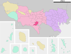
| Location Tamas in Tokyo Prefecture | ||
Tama ( Japanese 多 摩 市 , - shi ) is a city in Tokyo Prefecture and borders directly to the east of the city of Inagi .
History and geography
The community consists Tama area without significant change since the introduction of modern municipal orders in 1889, when it as Tama- mura in the district of South Tama of Kanagawa Prefecture several pre-modern villages of 1878 divided circle Tama united. In 1893 Tama was transferred to Tokyo Prefecture with the rest of the Tama area . The village was founded in 1964 as Tama- machi district town. In 1971, Tama and Inagi, the last two remaining parishes in South Tama County, became independent as -shi and the county ceased to exist.
Tama-shi was conceived as a residential city and finally founded on November 1, 1971 on the western edge of the Japanese capital Tokyo . It owes its name to the river Tama of the same name , which forms a natural city boundary in the north.
In addition to a base for the Japanese self-defense forces and a base for the US air force, Tama has also been home to an amusement park run by the Japanese company Sanrio since 1990 , in which the character Hello Kitty is the focus.
traffic
- train
- Keiō Line to Shinjuku
- Keiō-Sagamihara Line to Shinjuku
- Odakyū Tama Line to Shinjuku
- Tama monorail
sons and daughters of the town
- Takao Doi (* 1954), astronaut
- Kenji Kitawaki (* 1991), football player
- Hiroto Ogata , guitarist for the band Alice Nine
- Kyōhei Shimazaki (* 1991), football player
- Keisuke Tsuboi (* 1979), football player
Neighboring cities and communities
Town twinning
-
 Fujimi , Japan


