Musashino
| Musashino-shi 武 蔵 野 市 |
||
|---|---|---|
| Geographical location in Japan | ||
|
|
||
| Region : | Kanto | |
| Prefecture : | Tokyo | |
| Coordinates : | 35 ° 43 ' N , 139 ° 34' E | |
| Basic data | ||
| Surface: | 10.73 km² | |
| Residents : | 148,326 (October 1, 2019) |
|
| Population density : | 13,823 inhabitants per km² | |
| Community key : | 13203-9 | |
| Symbols | ||
| Flag / coat of arms: | ||
| Tree : | Kobushi magnolia , Japanese zelkove , blossom dogwood | |
| Flower : | Hagi shrub , Lithospermum erythrorhizon , Orychophragmus violaceus , azalea , Daphne odora , daffodil , Hibiscus mutabilis , Ipomoea nil , garden chrysanthemum | |
| town hall | ||
| Address : |
Musashino City Hall 2 - 2 - 28 , Midori-chō Musashino -shi Tōkyō 180-8777 |
|
| Website URL: | http://www.city.musashino.lg.jp | |
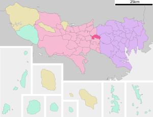
| Location of Musashinos in Tokyo Prefecture | ||
Musashino ( Japanese 武 蔵 野 市 , - shi ) is a city in Tokyo Prefecture, west of Tokyo .
geography
Musashino is west of Tokyo and north of Mitaka . Inokashira Park is on the border with this community .
history
In 1868 the Mura Kichijōji ( 吉祥寺 村 , -mura ) was incorporated, which continues today as the neighborhood Kichijōji .
Musashino was promoted to Shi on November 3, 1947 .
traffic
- Train: Kichijōji Station
- JR Chūō-Sōbu Line : to Akihabara , Shinjuku and Chiba
- JR Chūō Main Line : to Tokyo or Hachioji
- Keio Inokashira Line : to Shibuya
sons and daughters of the town
- Ryōta Iwabuchi (* 1990), football player
- Miyu Katō (* 1999), table tennis player
- Yūto Misao (* 1991), football player
- Yasuo Tanaka (* 1956), writer and politician
- Eriko Yamatani (* 1950), politician
- Imura Yūdai (* 1991), football player
Neighboring cities and communities
Web links
Commons : Musashino, Tokyo - Collection of images, videos and audio files


