Higashiyamato
| Higashiyamato-shi 東 大 和 市 |
||
|---|---|---|
| Geographical location in Japan | ||
|
|
||
| Region : | Kanto | |
| Prefecture : | Tokyo | |
| Coordinates : | 35 ° 45 ' N , 139 ° 26' E | |
| Basic data | ||
| Surface: | 13.54 km² | |
| Residents : | 84,223 (October 1, 2019) |
|
| Population density : | 6220 inhabitants per km² | |
| Community key : | 13220-9 | |
| Symbols | ||
| Flag / coat of arms: | ||
| Tree : | Japanese zelkove | |
| Flower : | azalea | |
| town hall | ||
| Address : |
Higashiyamato City Hall 3 - 930 Chūō Higashiyamato -shi Tōkyō 207-8585 |
|
| Website URL: | http://www.city.higashiyamato.lg.jp | |
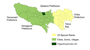
| Location of Higashiyamatos in Tokyo Prefecture | ||
Higashiyamato ( Japanese 東 大 和 市 , Higashi-Yamato- shi , "Tokyo's city of Yamato") is a city in the Japanese prefecture of Tokyo, west of Tokyo .
geography
Higashiyamato is west of Tokyo and north of Hachiōji .
history
The city was founded on October 1, 1970 . Before that there was already a village Yamato (Japanese 大 和村 , - Mura ), which was created in 1919 from a merger of several villages and in 1954 became a [district / rural] city (- machi ) . When it came to the appointment of a city (-shi) , the city name was prefixed with Higashi.
traffic
- Train:
- Seibu Ikebukuro Line : to Tokorozawa and Ikebukuro
sons and daughters of the town
- Nobuyuki Abe (* 1984), soccer player
- Akihiro Hayashi (born 1987), football player
- Kōichirō Morita (* 1984), football player
- Yūya Yagira (born 1990), actor
Neighboring cities and communities
- Tokyo prefecture
- Saitama Prefecture
Town twinning
-
 Kitakata , Japan
Web links
Commons : Higashiyamato - collection of images, videos and audio files
Individual evidence
- ↑ a b 東 (here Higashi- ) literally means “East”, but here stands for the Tō in Tōkyō, see 東 大 和 市 : 市 の 名称 「東 大 和」 の 名称 に つ い て . Yamato-shi , established in 1959, is located in Kanagawa almost exactly south, not west of Higashi-Yamato-shi.


