Kunitachi
| Kunitachi-shi 国立 市 |
||
|---|---|---|
| Geographical location in Japan | ||
|
|
||
| Region : | Kanto | |
| Prefecture : | Tokyo | |
| Coordinates : | 35 ° 41 ' N , 139 ° 26' E | |
| Height : | 74 m | |
| Basic data | ||
| Surface: | 8.15 km² | |
| Residents : | 75,156 (October 1, 2019) |
|
| Population density : | 9222 inhabitants per km² | |
| Community key : | 13215-2 | |
| Symbols | ||
| Flag / coat of arms: | ||
| Tree : | ginkgo | |
| Flower : | Ume | |
| Bird : | Great tit | |
| town hall | ||
| Address : |
Kunitachi City Hall 2 - 47 - 1 , Fujimidai Kunitachi -shi Tōkyō 186-8501 |
|
| Website URL: | http://www.city.kunitachi.tokyo.jp/ | |
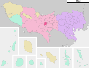
| Location of Kunitachis in Tokyo Prefecture | ||
Kunitachi ( Japanese 国立 市 , - shi ) is a city in the geographic center of Tokyo Prefecture .
geography
In the east Kunitachi borders on Fuchū , in the west on Tachikawa, in the north on Kokubunji and in the south the border with the city of Hino in Tamagawa runs .
Kunitachi is, measured at the town hall, 74 m above sea level. It has an east-west extension of 2.3 km and a north-south extension of 3.7 km.
history
During the modernization of the municipal regulations in 1889, the village of Yaho ( Yaho-mura , 谷 保 村 ) in North Tama County, which was part of Kanagawa until 1893, was established here. In 1951 Yabo was renamed Kunitachi-machi and became a [district] city (- machi ).
On January 1, 1967, Kunitachi was granted city rights.
population
- 36,460 men (including 632 foreigners)
- 37,239 women (including 734 foreigners)
- Total: 73,699 people (1,366 foreigners)
- Households: 34,262
Status: July 1, 2006
City arms
Kunitachi has a 5-petalled plum blossom with a double line in its coat of arms. Interpretation: The outer line of the coat of arms stands for the Chinese character Kuni ( 国 ), the inner line should stand for tachi ( 立 ) and also for the symbol for education and culture ( 文 ). In its entirety, it should reflect the 5 continents.
Origin of the city name
The name Kunitachi was chosen by the Hakone Tochi Kaihatsu Corporation when the area in the south of Yaho-Mura was developed towards the end of the Taishō period . At that time, the Chūō line directly connected Kokubunji ( 国 分 寺 ) and Tachikawa ( 立 川 ). Since the new station was built exactly in the middle between the two stations, the first sign of the two adjacent stations was used and the new city was named 国立 ( Kunitachi ). But it wasn't until April 1, 1951, that Kunitachi became the official name.
traffic
- Train:
- JR Chūō Main Line , Kunitachi Station , to Tokyo and Hachioji
- JR Nambu Line , to Kawasaki and Tachikawa
- Street:
sons and daughters of the town
- Shuichi Abe (* 1960), politician
- Kazuki Anzai (* 1994), football player
- Tatsuya Anzai (* 1996), soccer player


