
Kanagawa Prefecture
|
Kanagawa-ken 神奈川 県 |
|
|---|---|
  |
|
| Basic data | |
| Administrative headquarters : | Yokohama |
| Region : | Kanto |
| Main island : | Honshu |
| Area : | 2,416.3 km² |
| Water content: | 2.3 % |
| Residents : | 9.200.166 (October 1, 2019) |
| Population density : | 3808 inhabitants per km² |
| Counties : | 6th |
| Municipalities : | 33 |
| ISO 3166-2 : | JP-14 |
| Governor : | Yūji Kuroiwa |
| Website: | www.pref.kanagawa.jp |
| Symbols | |
| Prefecture flag : |
 |
| Prefecture tree : | ginkgo |
| Prefecture flower : | Lilium auratum |
| Vogel prefecture : | Common gull |
| Prefecture song : |
Hikari arata ni ("A fresh ray of light") |
The Kanagawa Prefecture ( Jap. 神奈川県 , Kanagawa-ken ) is a prefecture of Japan and is located in the region Kanto on Honshu . The prefecture is part of the Tokyo metropolitan area . The seat of the prefecture administration is Yokohama . Since May 2006 Kanagawa has been ranked second among the Japanese prefectures by population behind Tokyo .
Kanagawa and Baden-Württemberg have maintained a bilateral partnership since 1989.
History of the name
Kanagawa originally referred to the area of Kuraki-gun ( 久 良 岐 郡 ) in the east of the Musashi Province (today the city of Yokohama ). The area was a very important shipping port and trading center and still has a large port facility today. In 1854, after the arrival of the American fleet under Commodore Matthew Perry , the Japanese government concluded the Treaty of Kanagawa with the United States here . At the same time, a central trading post was established, called Kanagawa Bugyō-sho . In 1868 the name Kanagawa was adopted for the newly established prefecture.
geography
Kanagawa Prefecture is located in the southwestern part of the Kantō Plain , roughly in the center of the Japanese main island of Honshū . Kanagawa Prefecture is adjacent to the capital Tokyo in the north, and the sea in the east and south. To the west it borders on the prefectures of Yamanashi and Shizuoka .
The geographic extent ranges from
- 139 ° 47 ′ 58 "to 138 ° 55 ′ 8" east longitude and from
- 35 ° 7 ′ 32 ″ to 35 ° 40 ′ 10 ″ north latitude.
The area can be divided into three different zones. The mountains and hills in the west and north-west with the mountain ranges of Hakone and Tanzawa (highest point: Hirugatake 1673 m). In the center the flat plains with the Sagami River, an important water dispenser for the entire region. To the south and east hills. The prefecture has a total of 426 km of coastline to Sagami Bay in the south and Tokyo Bay in the northwest. The two bays are separated from each other by the Miura peninsula, which belongs entirely to the prefecture .
climate
Warm ocean currents create a mild climate. In the coastal areas, the summer is not quite as hot and the winter is not quite as cold as in the interior. Over the whole year, however, the temperatures go below 0 ° C in winter and well over 30 ° C in summer.
- Average temperature: 16.9 ° C
- Maximum temperature: 36.5 ° C
- Minimum temperature: −0.7 ° C
- Average rainfall per year: 1932 mm
(Source: Yokohama Local Meteorological Observatory, 2004)
history
A first prefecture of Kanagawa emerged in the Meiji Restoration in 1868 as the successor to the Kanagawa shogunate administration ( Kanagawa bugyōsho ) , which had administered the Yokohama port opened by the colonial powers in 1859 , initially on 19.3. (Gregorian April 11) as Yokohama saibansho , one month later as Kanagawa saibansho and on June 17. (August 5th) 1868 as [City] Prefecture (-fu) Kanagawa. In the same year (September 21 / November 5, general) Kanagawa was finally converted into an ordinary prefecture (-ken) ; the status of -fu was reserved from 1869 for the three capital city prefectures of Kyoto , Osaka and Tokyo . With the abolition of the principalities (-han) and the first consolidation of the prefectures in 1871/72, in addition to the purification of ex- / enclaves, the prefecture (-ken) Mutsuura, which emerged from the principality of the same name (-han) , and other parts of the former shogunate domain were assigned Kanagawa. Thereafter, the prefecture comprised territory along both sides of the border between the provinces of Musashi and Sagami - about the eastern half of its current area and also the western main part ( Tama area ) of Tama County . In the western part of today's Kanagawa and the eastern part of today's Shizuoka , the Ashigara prefecture emerged in the provinces of Sagami and Izu from the principalities of Ogino-Yamanaka and Odawara and the shogunate countries previously combined in the Nirayama prefecture . In 1876 Ashigara was divided between Shizuoka and Kanagawa on the provincial border of Izu and Sagami. In 1893 the Tama area was transferred from Kanagawa to Tokyo. With this, Kanagawa achieved, apart from minor changes due to cross-prefectural community mergers, its present territory, which essentially corresponds to the entire ancient province of Sagami and three counties (Tsuzuki, Tachibana, Kuraki) of the Musashi province.
politics
(as of May 24, 2019)
- LDP : 49
- Rikken minshutō ・ minken club (" KDP , club [for] people's / civil rights"): 26
- Kōmeitō : 8
- Kanagawa kenmin ・ minshu Forum ("Forum of Prefectural Citizens , Democrat Kanagawa"; with DVP ): 8
- Kenseikai (~ "Prefectural Political Assembly "): 5
- KPY : 5
- Four further factions (including the Kanagawa network movement ): 4


The former news anchor Yūji Kuroiwa has been governor of Kanagawa since 2011, who was re-elected for a third term in the unified regional elections in April 2019 as a bourgeois all-party candidate with a three-quarters majority against just one communist challenger. Also in the unified regional elections, the 105-member parliament was re-elected: The Liberal Democratic Party remained clearly the strongest party with 47 seats, the Constitutional Democratic Party gained significantly and received 23 seats, losses were recorded by the DVP , Kōmeitō and KPJ .
In the national parliament , the prefecture is represented by 18 directly elected members of the Shūgiin and is part of the proportional electoral bloc South Kantō; ins Sangiin , Kanagawa elects four representatives per partial election, i.e. is represented by eight MPs. The 18 Shugiin constituencies be after the election in 2017 and party Jump since (as of July 2019) of 13 Liberal Democrats, four members of the KDP representative fraction and one-party and non-attached member. The Sangiin constituency of Kanagawa will be represented by three Liberal Democrats, two members each from KDP and Kōmeitō, and former governor Shigefumi Matsuzawa for Nippon Ishin no Kai after the 2016 and 2019 elections and party reshuffles since .
police


The Kanagawa Prefectural Police ( 神奈川 県 警察 , Kanagawa ken-keisatsu ) is the third largest prefectural police in the country with over 15,000 police officers. As in all prefectures, it is subordinate to the Prefectural Public Security Commission (ken kōan iinkai) , which in Kanagawa (as in all prefectures with designated cities or special districts) has five members for three-year terms; three are appointed by the governor with the approval of the prefectural parliament, and two are appointed by the mayors and parliaments of the designated cities in Kanagawa. There are 54 police stations across the prefecture. For national coordination and equipment, the Kanagawa Police Department is assigned to the Kantō Police Regional Office (Kantō kanku keisatsu-kyoku) of the national police authority .

Administrative division
When the Prussian municipal ordinances were introduced in 1889, Kanagawa was divided into 321 municipalities, including Yokohama (the first and until 1907) the only independent city and 27 additional cities - spread over 15 districts.
The number of municipalities fell in almost 100 years from 200 (1920), over 117 (1950), 58 (1955) and 39 (1960) to currently (since November 2007) 33. The current structure shows 19 district-free ( -shi ) and 13 towns ( -machi ) belonging to the district and one village ( -mura ). The number of counties ( -gun ) is six, two of which consist of only one municipality each.
Nine of the independent cities are organized in special forms for large cities:
-
"Designated Big Cities" ( Seirei shitei toshi ) - the prefectural seat of Yokohama as well as the cities of Kawasaki and Sagamihara.
The only prefecture with three cities of this special form. - Core city (Chūkakushi) - Yokosuka.
- “Exceptional Cities ” (Tokureishi) - Chigasaki (2003), Atsugi (2002), Hiratsuka (2001), Odawara and Yamato (since 2000).
In the table below, the districts ( 郡 , - gun ) are shown in italics, below each (indented) the small towns ( 町 , -machi ) and the village ( 村 , -mura ) within them. At the beginning of the table are the independent cities ( 市 , - shi ). In the authority code (1st column), the first two digits are the prefecture (Kanagawa is 14), the third position is the type of authority: prefecture / -ken 0, designated city / [seirei] -shi and its [administrative] districts / [gyōsei] -ku 1, other independent city / -shi 2, [district members / rural] city / -machi or village / -mura 3 to 7. In the last two places -machi and -mura of a former district as Consecutive group put together starting with 1 in the last digit; however, through community mergers / incorporations in / upgrading to urban districts, gaps later emerged in many places. Although the local authority code was only introduced in this form decades after the districts / guns were abolished as an administrative unit, they were also assigned round keys that could be used for geographical and statistical purposes, divisible by 10: the 0 in front of the associated municipalities; these circle keys are used by the state surveying office ( Kokudo Chiriin ; at that time still called the "Geographical Survey Institute", GSI, today translated into English as the "Geospatial Information Authority of Japan", literally "geographic / -s (chiri) institute " ) / -ion (-in) [for the] national territory / country (kokudo) ”).
| code | Surname | Area (in km²) | population | Population density (inh / km²) 3 |
||
|---|---|---|---|---|---|---|
| Rōmaji | Kanji | October 1, 2017 1 | October 1, 2019 2 | October 1, 2015 3 | ||
| 14100 | Yokohama- shi | 横 浜 市 | 437.56 | 3,748,781 | 3,724,844 | 8512.76 |
| 14130 | Kawasaki- shi | 川 崎 市 | 143.01 | 1,530,457 | 1,475,213 | 10315.45 |
| 14150 | Sagamihara- shi | 相 模 原 市 | 328.91 | 722.828 | 720.780 | 2191.42 |
| 14201 | Yokosuka- shi | 横須賀 市 | 100.82 | 393,894 | 406,586 | 4032.79 |
| 14203 | Hiratsuka- shi | 平 塚 市 | 67.82 | 257.729 | 258.227 | 3807.53 |
| 14204 | Kamakura- shi | 鎌倉 市 | 39.67 | 172.262 | 173.019 | 4361.46 |
| 14205 | Fujisawa- shi | 藤 沢 市 | 69.56 | 434,568 | 423,894 | 6093.93 |
| 14206 | Odawara- shi | 小田原 市 | 113.81 | 190.109 | 194.086 | 1705.35 |
| 14207 | Chigasaki- shi | 茅 ヶ 崎 市 | 35.70 | 241,887 | 239,348 | 6704.43 |
| 14208 | Zushi- shi | 逗 子 市 | 17.28 | 56,936 | 57,425 | 3323.21 |
| 14210 | Miura- shi | 三浦 市 | 32.05 | 42,488 | 45.289 | 1413.07 |
| 14211 | Hadano- shi | 秦 野 市 | 103.76 | 165.051 | 167.378 | 1613.13 |
| 14212 | Atsugi- shi | 厚 木 市 | 93.84 | 224,677 | 225.714 | 2405.31 |
| 14213 | Yamato- shi | 大 和 市 | 27.09 | 237,445 | 232.922 | 8598.08 |
| 14214 | Isehara- shi | 伊 勢 原 市 | 55.56 | 102.137 | 101,514 | 1827.11 |
| 14215 | Ebina- shi | 海 老 名 市 | 26.59 | 133,706 | 130.190 | 4896.20 |
| 14216 | Zama- shi | 座 間 市 | 17.57 | 130.608 | 128,737 | 7327.09 |
| 14217 | Minamiashigara- shi | 南 足 柄 市 | 77.12 | 41,814 | 43,306 | 561.54 |
| 14218 | Ayase- shi | 綾 瀬 市 | 22.14 | 84,372 | 84,460 | 3814.81 |
| 14300 | Miura gun | 三浦 郡 | 17.04 | 32.096 | 1883.57 | |
| 14301 | Hayama- machi | 葉 山 町 | 17.04 | 31,683 | 32.096 | 1883.57 |
| 14320 | Koza-gun | 高 座 郡 | 13.34 | 47,936 | 3593.40 | |
| 14321 | Samukawa- machi | 寒 川 町 | 13.34 | 48,379 | 47,936 | 3593.40 |
| 14340 | Naka-gun | 中 郡 | 26.25 | 59,928 | 2282.97 | |
| 14341 | Ōiso- machi | 大 磯 町 | 17.18 | 31,284 | 31,550 | 1836.44 |
| 14342 | Ninomiya- machi | 二 宮 町 | 9.08 | 27,744 | 28,378 | 3125.33 |
| 14360 | Ashigarakami-gun | 足 柄 上郡 | 303.28 | 65,620 | 216.37 | |
| 14361 | Nakai- machi | 中 井 町 | 19.99 | 9368 | 9679 | 484.19 |
| 14362 | Ōi-machi | 大 井 町 | 14.38 | 17,060 | 17,033 | 1184.49 |
| 14363 | Matsuda- machi | 松田 町 | 37.75 | 10,884 | 11,171 | 295.92 |
| 14364 | Yamakita-machi | 山 北 町 | 224.61 | 9702 | 10,724 | 47.74 |
| 14366 | Kaisei-machi | 開 成 町 | 6.55 | 18,010 | 17,013 | 2597.40 |
| 14380 | Ashigarashimo gun | 足 柄 下 郡 | 140.87 | 44,145 | 313.37 | |
| 14382 | Hakone- machi | 箱根 町 | 92.86 | 11,169 | 11,786 | 126.92 |
| 14383 | Manazuru-machi | 真 鶴 町 | 7.05 | 6843 | 7333 | 1040.14 |
| 14384 | Yugawara-machi | 湯河 原 町 | 40.97 | 23,802 | 25,026 | 610.84 |
| 14400 | Aikō-gun | 愛 甲 郡 | 105.52 | 43,557 | 412.78 | |
| 14401 | Aikawa-machi | 愛 川 町 | 34.28 | 39,381 | 40,343 | 1176.87 |
| 14402 | Kiyokawa-mura | 清 川村 | 71.24 | 3108 | 3214 | 45.12 |
| Shi-bu ( All Shi , proportion of urban districts) | 市 部 | 1809.86 | 8,889,872 | 8,832,932 | 4880.45 | |
| Gun-bu ( All Gun , percentage of counties) | 郡 部 | 606.31 | 289.963 | 293,282 | 483.72 | |
| 14000 | Kanagawa-Ken (Kanagawa Prefecture) | 神奈川 県 | 2416.17 | 9,179,835 | 9,126,214 | 3777.14 |
- There are areas with an unclear course of the municipality boundaries.
swell
1 Area data from 2017
2 Estimated population 2018
3 Results of the 2015 census
Biggest places
| VZ year | Residents | |||
|---|---|---|---|---|
| 2015 | 2010 | 2005 | 2000 | |
| Yokohama | 3,724,844 | 3,688,773 | 3,579,628 | 3,426,651 |
| Kawasaki | 1,475,213 | 1,425,512 | 1,327,011 | 1,249,905 |
| Sagamihara | 720.780 | 717,544 | 628,698 | 605,561 |
| Fujisawa | 423,894 | 409,657 | 396.014 | 379.185 |
| Yokosuka | 406,586 | 418.325 | 426.178 | 428,645 |
| Hiratsuka | 258.227 | 260.780 | 258,958 | 254,633 |
| Chigasaki | 239,348 | 235.081 | 228.420 | 220,809 |
| Yamato | 232.922 | 228.186 | 221.220 | 212,761 |
| Atsugi | 225.714 | 224.420 | 222.403 | 217,369 |
| Odawara | 194.086 | 198,327 | 198,741 | 200.173 |
| Kamakura | 173.019 | 174.314 | 171.158 | 167,583 |
| Hadano | 167.378 | 170.145 | 168.317 | 168.142 |
| Ebina | 130.190 | 127,707 | 123.764 | 117,519 |
| Zama | 128,737 | 129,436 | 128.174 | 125,694 |
| Isehara | 101,514 | 101.039 | 100,579 | 99,544 |
| Ayase | 84,460 | 83.167 | 81,767 | 81,019 |
| Zushi | 57,425 | 58,302 | 58.033 | 57,281 |
| Miura | 45.289 | 48,352 | 49,861 | 52,253 |
| Minamiashigara | 43,306 | 44.020 | 44.134 | 44,156 |
- In the specified period (2000–2015) there were only two boundary changes in the cities: The incorporation of two communities into the city of Sagamihara (March 2006 and March 2007).
- The number of cities has remained unchanged since November 1978: Ayase became a city.
Partnerships
Kanagawa has international partnerships with the following regions:
- the state of Maryland in the USA,
- the province of Liaoning in the People's Republic of China,
- the state of Baden-Württemberg in Germany,
- of Gyeonggi Province in the Republic of Korea,
- the Odessa region in Ukraine,
- the state of Penang in Malaysia,
- the province of Västra Götaland in Sweden and
- the city of Gold Coast in Queensland, Australia - this partnership was concluded jointly with 13 communities in Kanagawa on Sagami Bay and is thus essentially a regional partnership between the Sagami Coast and the Gold Coast.
In addition, the individual communities in Kanagawa maintain numerous international city partnerships.
economy
According to the cabinet office, the gross domestic product of Kanagawa in fiscal year 2014 was 30.3 trillion yen , which corresponded to around 5.9% of the total Japanese economic output.
The legal minimum wage in Kanagawa is 983 yen from October 2018 to 2019, making it the second highest in the country after Tokyo (¥ 985).
Demographics

As a highly urbanized and economically developed prefecture in the Kantō metropolitan region, Kanagawa is currently still seeing some population growth even as the nationwide demographic change has begun. According to the 2015 census, Kanagawa had 9,126,214 inhabitants in 3,979,278 households, an increase of 0.9% compared to the 2010 census. The population is already declining significantly in some more rural areas in the west, for example the population of the city of Yamakita between the 1995 and 2015 censuses from over 14,000 to under 11,000, that of the city of Hakone from over 18,000 to under 12,000.
As of January 1, 2018, there were 198,504 foreigners registered in Kanagawa, including around 65,000 from China (People's Republic), 27,500 from Korea (Republic), 21,000 from the Philippines and around 16,000 from Vietnam. The number of residents from Nepal, Vietnam and Sri Lanka has risen significantly recently.
Population development in the prefecture
| Census year |
Total population |
male population |
female population |
Gender ratio men to 1000 women |
Area in km² |
Population density per km 2 |
|---|---|---|---|---|---|---|
| 1920 | 1,323,390 | 689.751 | 633,639 | 1089 | 2351.63 | 562.8 |
| 1925 | 1,416,792 | 739.699 | 677.093 | 1093 | 2351.63 | 602.5 |
| 1930 | 1,619,606 | 839.309 | 780.297 | 1076 | 2353.48 | 688.2 |
| 1935 | 1,840,005 | 951.348 | 888.657 | 1071 | 2352.81 | 782.1 |
| 1940 | 2,188,974 | 1,137,936 | 1,051,038 | 1083 | 2352.81 | 930.4 |
| 1945 | 1,865,667 | 922,522 | 943.145 | 978 | 2352.81 | 793.0 |
| 1950 | 2,487,665 | 1,247,934 | 1,239,731 | 1007 | 2361.13 | 1053.6 |
| 1955 | 2,919,497 | 1,470,415 | 1,449,082 | 1015 | 2361.37 | 1236.4 |
| 1960 | 3,443,176 | 1,746,926 | 1,696,250 | 1030 | 2361.37 | 1458.1 |
| 1965 | 4,430,743 | 2,280,926 | 2,149,817 | 1061 | 2374.62 | 1865.9 |
| 1970 | 5,472,247 | 2,822,212 | 2,650,035 | 1065 | 2384.72 | 2294.7 |
| 1975 | 6,397,748 | 3,287,118 | 3,110,630 | 1057 | 2390.80 | 2676.0 |
| 1980 | 6,924,348 | 3,536,021 | 3,388,327 | 1044 | 2397.10 | 2888.6 |
| 1985 | 7,431,974 | 3,804,081 | 3,627,893 | 1049 | 2402.07 | 3094.0 |
| 1990 | 7,980,391 | 4,098,147 | 3,882,244 | 1056 | 2412.11 | 3308.5 |
| 1995 | 8,245,900 | 4,209,525 | 4,036,375 | 1043 | 2413.58 | 3416.5 |
| 2000 | 8,489,974 | 4,308,786 | 4,181,188 | 1031 | 2415.41 | 3514.9 |
| 2005 | 8,791,597 | 4,444,555 | 4,347,042 | 1022 | 2415.84 | 3639.2 |
| 2010 | 9,048,331 | 4,544,545 | 4,503,786 | 1009 | 2415.86 | 3745.4 |
| 2015 | 9,126,214 | 4,558,978 | 4,567,236 | 998 | 2415.83 | 3777.7 |
tourism
Yokohama
In Yokohama is the tallest building in Japan until 2010, the 296 m high Yokohama Landmark Tower . With the largest Chinatown in Japan and other foreigners living in Yokohama, the city has a multicultural flair.
Kamakura
The former capital Kamakura has a number of Buddhist temples and Shinto shrines . The 13.35 m high bronze statue of Amida Buddha, which has been standing outdoors since a tsunami in the 15th century that destroyed the surrounding temple, is well known.
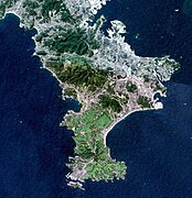
SRTM image of the Miura Peninsula


literature
- Neil L. Waters: The Second Transition: Early to Mid-Meiji in Kanagawa Prefecture . In: The Journal of Asian Studies , Vol. 49, No. 2, 1990, pp. 305-322.
Web links
Individual evidence
- ↑ Governor of the Japanese province of Kanagawa visits Baden-Württemberg on the occasion of 20 years of partnership. In: Baden-Württemberg state portal. June 12, 2009. Retrieved June 14, 2009 .
- ↑ Tadamitsu Saitō ( Nihon chizu gakkai / 日本 地 図 学会 / Japanese Cartographic Society): Map of the prefectures in the 11th month of the year Meiji 4 (greg. Dec. 1871 / Jan. 1872) in 北 関 東 3 県 は 「宇 都 宮 県」 に幻 の 28 道 府 県 案 . In: Nihon Keizai Shimbun , electronic edition. September 25, 2015. Retrieved March 14, 2017 (Japanese).
- ↑ Kanagawa Prefectural Administration: Origin of the name, "Founding Day " (ritchō kinenbi) , origin (Japanese)
- ↑ Kanagawa Prefectural Parliament : MPs by Group , accessed August 6, 2019.
- ↑ 統一 地方 選 2019 神奈川 県 議 選 各 党 議席 . In: NHK Senkyo Web. April 8, 2019, accessed May 22, 2019 (Japanese).
- ↑ Kanagawa Prefectural Police: Air Corps (kōkūtai)
- ↑ Kanagawa Prefectural Police (Japanese, English)
- ↑ Kanagawa Prefectural Public Safety Commission (Japanese)
- ↑ Kantō Regional Office of the National Police Department (Japanese)
- ↑ Kokudo Chiriin (GSI - Geospatial Information Authority of Japan), 平 成 29 年 全国 都 道 府 県 市区 町 村 別 面積 調 (Nationwide survey of all prefectures and municipalities 2017) , p. 43: 14 Niigata-ken (Japanese), accessed on 28 February 2019
- ↑ 簡 単 検 索 ・ 詳細 検 索 ・ 検 索 サ ン プ ル , accessed February 28, 2019 (Japanese)
- ↑ e-stat (English), accessed on February 28, 2019
- ↑ e-Stat database , accessed on April 1, 2019 (English)
- ↑ Kanagawa Prefectural Administration (Kanagawa-kenchō) , "(Prefectural) Citizens Office" (kenmin-kyoku) , "Department for Life and Citizens" (kurashi-kenmin-bu) , "[ Sub ] Department for International Affairs" (kokusai-ka ) : 国際 交流 の 推進> 神奈川 県 と 友好 交流 先 等 と の 交流 (Japanese, English )
- ↑ Kanagawa Prefectural Administration: List and map of the international town twinning of the municipalities in the prefecture (Japanese, English (list only) )
- ↑ Naikaku-fu , keizai shakai sōgō kenkyūjo ( 経 済 社会 総 合 研究所 , “General Research Institute for Economy and Society”), kenmin keizai kessan ( 県 民 経 済 計算 , “Prefecture National Accounts”), May 26, 2017: 済 済 26 年度 年度 年度計算 に つ い て , Retrieved July 30, 2018.
- ^ MHLW : List of minimum wages in all prefectures
- ↑ Kanagawa kenchō (Kanagawa Prefecture Administration), tōkei center (Statistics Center): 平 成 27 年 国 勢 調査 人口 等 基本 集 集 結果 (神奈川 県 の 確定 数)
- ↑ Kanagawa kenchō (Prefectural Administration of Kanagawa), kokusai-bunka-kankō-kyoku (Office for International Affairs, Culture, Tourism): 県 内 外国人 統計 (外国人 登録 者 統計 , 市 (区) 町 村 別 主要 国 ・ 地域 別 外国 人数(2018 (平 成 30) 年 1 月 1 日 現在) (pdf)
- ↑ 神奈川 の 外国人 居住者 6.8 % 増 、 ア ジ ア 新興 国 伸 び る . In: nikkei.com . April 18, 2018, Retrieved July 30, 2018 (Japanese).
- ↑ e-Stat database , accessed on April 1, 2019 (English)
Aichi | Akita | Aomori | Chiba | Ehime | Fukui | Fukuoka | Fukushima | Gifu | Gunma | Hiroshima | Hokkaidō | Hyōgo | Ibaraki | Ishikawa | Iwate | Kagawa | Kagoshima | Kanagawa | Kochi | Kumamoto | Kyoto | Mie | Miyagi | Miyazaki | Nagano | Nagasaki | Nara | Niigata | Ōita | Okayama | Okinawa | Osaka | Saga | Saitama | Shiga | Shimane | Shizuoka | Tochigi | Tokyo | Tokushima | Tottori | Toyama | Wakayama | Yamagata | Yamaguchi | Yamanashi
Coordinates: 35 ° 26 ' N , 139 ° 30' E