Ninomiya (Kanagawa)
| Ninomiya-machi 二 宮 町 |
||
|---|---|---|
| Geographical location in Japan | ||
|
|
||
| Region : | Kanto | |
| Prefecture : | Kanagawa | |
| Coordinates : | 35 ° 18 ' N , 139 ° 15' E | |
| Basic data | ||
| Surface: | 9.08 km² | |
| Residents : | 27,744 (October 1, 2019) |
|
| Population density : | 3056 inhabitants per km² | |
| Community key : | 14342-1 | |
| Symbols | ||
| Flag / coat of arms: | ||
| Tree : | camellia | |
| Flower : | Flower tube | |
| town hall | ||
| Address : |
Ninomiya Town Hall 961 Ninomiya Ninomiya - machi , Naka-gun Kanagawa 259-0196 |
|
| Website URL: | http://www.town.ninomiya.kanagawa.jp | |
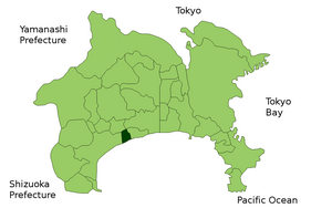
| Location Ninomiyas in Kanagawa Prefecture | ||
Ninomiya ( Japanese 二 宮 町 , -machi ) is a small town on the Japanese main island of Honshū in Naka County in Kanagawa Prefecture .
Ninomiya is located south of Tokyo and Yokohama on Sagami Bay .
Neighboring cities and communities
traffic
Ninomiya is located on National Road 1 from Tōkyō to Kyoto . The city can be reached by rail on the Tōkaidō Main Line ( Ninomiya Station ). From 1906 to 1935 the Shōnan tram ran to Hadano .
sons and daughters of the town
- Shinri Suzuki (cyclist)


