
Matsuda (Kanagawa)
| Matsuda-machi 松田 町 |
|||
|---|---|---|---|
 |
|||
| Geographical location in Japan | |||
|
|||
| Region : | Kanto | ||
| Prefecture : | Kanagawa | ||
| Coordinates : | 35 ° 21 ' N , 139 ° 9' E | ||
| Height : | 63 m | ||
| Basic data | |||
| Surface: | 37.75 km² | ||
| Residents : | 10,884 (October 1, 2019) |
||
| Population density : | 288 inhabitants per km² | ||
| Community key : | 14363-4 | ||
| Postal code area : | 258-85xx | ||
| Symbols | |||
| Flag / coat of arms: |
 |
||
| Tree : | Sky bamboo | ||
| Flower : | Cosmos | ||
| town hall | |||
| Address : |
Matsuda Town Hall 2037 Shoryo Matsuda- machi , Ashigarakami-gun Kanagawa 258-8585 |
||
| Website URL: | town.matsuda.kanagawa.jp | ||
| Location of Matsudas in Kanagawa Prefecture | |||
 |
|||

Matsuda ( Japanese 松田 町 , - machi ) is a city on the island of Honshū in Japan . It belongs to Ashigarakami County in Kanagawa Prefecture . In 2018 it had 10,962 inhabitants; With an area of 37.75 km², this corresponds to a population density of 290 inhabitants per km².
geography
Matsuda is located in the western part of Kanagawa Prefecture in the Tanzawa Hills . The confluence of the Kawaoto and the Sakawa is located in the very south of the urban area . In this area, on the extreme northern edge of the Ashigara Plain , the population is mainly concentrated. The majority of the urban area is located in hilly to mountainous terrain and extends along the valley of the Nakatsu, a tributary of the Kawaoto. The village of Yadoriki is located in this densely forested valley. The highest point is the summit of Nabewari-yama on 1272 m TP neighboring municipalities are Hadano in the east, Ōi in the south, Kaisei in the southwest, Minamiashigara the west and Yamakita the northwest.
history
During the Edo period, today's urban area belonged to the Odawara fiefdom in Sagami province . After the Han was abolished in 1871, it was part of the short-lived Ashigara Prefecture , and since 1876 it has belonged to Kanagawa Prefecture. On April 1, 1889, the villages of Matsudasōryō, Matsudasoshi and Kamiyama merged to form the independent community of Matsuda in Ashigarakami County. The connection to the railway network in the same year triggered a surge in growth, so that Matsuda received city status on April 1, 1909. The Great Kanto earthquake of 1923 caused enormous damage. In 1927, the Odakyū Dentetsu opened a more direct railway line to Tokyo . On April 1, 1955, Yadoriki was incorporated. In 1995 the city reached its highest level with 13,290 inhabitants, since then the population has been declining.
traffic
There are two train stations in the city center, Matsuda station on the Gotemba line ( Numazu - Odawara ) and Shin-Matsuda station on the Odakyū Odawara line (Odawara– Tokyo-Shinjuku ). The city is served by the Tōmei highway , the most important east-west highway connection in Japan, as well as by national roads 246 and 255.
Attractions
The main tourist attraction of Matsuda is Nishihirahata Park north of the city center. In addition to the large herb garden with numerous planted herbs, a park railway that is 1.1 km long also attracts numerous visitors. Also worth seeing is the view from the park of Sagami Bay and Mount Fuji . Other attractions include Emmei-ji Temple, Samuta Shrine, Nakazawa Sake Brewery, Yadoriki Animal Park and a golf course .
photos

Nabewari-yama
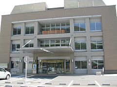
town hall

Herb garden in Nishihirahata Park

Samuta shrine


Web links
- Matsuda City Website (Japanese)
Individual evidence
- ↑ 町 の プ ロ フ ィ ー ル. City of Matsuda, December 11, 2017, accessed October 16, 2018 (Japanese).
- ↑ Nishihirahata Park. Retrieved October 16, 2018 (Japanese).
Independent cities ( shi ): Atsugi | Ayase | Chigasaki | Ebina | Fujisawa | Hadano | Hiratsuka | Isehara | Kamakura | Kawasaki | Minamiashigara | Miura | Odawara | Sagamihara | Yamato | Yokohama (administrative headquarters) | Yokosuka | Zama | Zushi
Aikō-gun : Aikawa | Kiyokawa | Ashigarakami-gun : Kaisei | Matsuda | Nakai | Ōi | Yamakita | Ashigarashimo-gun : Hakone | Manazuru | Yugawara | Kōza-gun : Samukawa | Miura-gun : Hayama | Naka-gun : Ninomiya | Ōiso