Chigasaki
| Chigasaki-shi 茅 ヶ 崎 市 |
||
|---|---|---|
| Geographical location in Japan | ||
|
|
||
| Region : | Kanto | |
| Prefecture : | Kanagawa | |
| Coordinates : | 35 ° 20 ' N , 139 ° 24' E | |
| Basic data | ||
| Surface: | 35.71 km² | |
| Residents : | 241,887 (October 1, 2019) |
|
| Population density : | 6774 inhabitants per km² | |
| Community key : | 14207-7 | |
| Symbols | ||
| Flag / coat of arms: | ||
| Tree : | acacia | |
| Flower : | azalea | |
| Bird : | Great tit | |
| town hall | ||
| Address : |
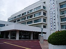
Chigasaki City Hall 1 - 1 - 1 , Chigasaki Chigasaki -shi Kanagawa 253-8686 |
|
| Website URL: | http://www.city.chigasaki.kanagawa.jp/ | |
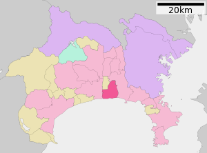
| Location Chigasakis in Kanagawa Prefecture | ||
Chigasaki ( Japanese 茅 ヶ 崎 市 , - shi ) is a city in the center of Kanagawa Prefecture .
geography
Chigasaki is south of Tokyo and Yokohama , west of Fujisawa, and east of Hiratsuka on Sagami Bay . A stretch of beach in Chigasaki is called Southern Beach , after the pop group Southern All Stars whose lead singer Keisuke Kuwata is from Chigasaki. As a popular seaside resort, Chigasaki is known as the birthplace of Japanese surfing. A shop called Goddess was Japan's first surfboard shop . The symbol of Southern Beach is the Eboshi-iwa , a large hat-shaped rock visible from the coast.
The coastline from Chigasaki to Kamakura is called Shōnan .
The Sagami flows through the city from northwest to southwest.
Attractions
- Shonan Beach
traffic
- Street:
- National road 1 , to Tōkyō or Kyōto
- Train: The JR Tōkaidō Main Line to Tokyo or Atami and the Sagami Line to Hashimoto stop at Chigasaki Station .
economy
Neighboring cities and communities
Town twinning
-
 Okazaki , Japan, since 1983
sons and daughters of the town
- Fumiyuki Beppu (* 1983), professional cyclist
- Takumi Beppu (* 1979), professional cyclist
- Ailes Gilmour , early pioneer of the American modern dance movement
- Keisuke Kuwata , lead singer for the Southern All Stars
- Noguchi Sōichi (* 1965), astronaut
- Ai Sugiyama (* 1975), tennis player
- Masa Yamamoto (born 1965), baseball player
Web links
Commons : Chigasaki - collection of images, videos and audio files


