
Kochi Prefecture
|
Kōchi-ken 高 知 県 |
|
|---|---|
  |
|
| Basic data | |
| Administrative headquarters : | Kochi |
| Region : | Shikoku |
| Main island : | Shikoku |
| Area : | 7,103.64 km² |
| Water content: | 0.2 % |
| Residents : | 697,674 (October 1, 2019) |
| Population density : | 98 inhabitants per km² |
| Counties : | 6th |
| Municipalities : | 34 |
| ISO 3166-2 : | JP-39 |
| Governor : | Seiji Hamada |
| Website: | http://www.pref.kochi.lg.jp/ |
| Symbols | |
| Prefecture flag : |
 |
| Prefecture tree : | Yanase- Japanese cedar |
| Prefecture flower : | Myrica rubra |
| Vogel prefecture : | Nymph pitta |
| Fish prefecture : | Real bonito |
| Prefecture song : |
Kōchi-kenmin no uta ("Song of the Citizens of Kōchi") |


The prefecture of Kōchi ( Japanese 高 知 県 , Kōchi-ken ) is one of the prefectures of Japan . It emerged in 1871 from the Principality of Tosa / Kōchi (Kōchi-han) and in 1880, when it was finally separated from Tokushima , it essentially reached its present-day expansion corresponding to the province of Tosa . The prefecture is located in the Shikoku region on Shikoku Island. The seat of the prefecture administration is the city of the same name Kōchi (Kōchi-shi) .
Administrative division
Since 2008, the prefecture has been divided into eleven cities ( Shi ) as well as 17 (district / small) cities ( Chō ) and six villages ( Son ). The latter are organized in six districts ( Gun ).
After the introduction of today's community forms, there were 197 communities in 1889, only one of which was independent and two of which were part of the district. On September 1, 2003 there were still 9 urban districts and 25 urban districts as well as 19 villages and 7 rural districts. When Kami-shi City was established on March 1, 2006, Kami-gun County was dissolved.
In the table below, the districts (郡) are shown in italics, underneath each (indented) the small towns (町) and the villages (村) within them. A dependency between rural district and small town can also be seen in the first three digits of the code (1st column). At the beginning of the table are the independent cities (市).
| code | Surname | Area (in km²) | population | Population density (inh / km²) |
||
|---|---|---|---|---|---|---|
| Rōmaji | Kanji | 01.10.2017 1 | 01.10.2018 2 | 01/10/2015 3 | ||
| 39201 | Kochi- shi | 高 知 市 | 309.00 | 331.414 | 337.190 | 1091.23 |
| 39202 | Muroto- shi | 室 戸 市 | 248.18 | 12,386 | 13,524 | 54.49 |
| 39203 | Aki- shi | 安 芸 市 | 317.21 | 16,764 | 17,577 | 55.41 |
| 39204 | Nankoku- shi | 南国 市 | 125.30 | 47.294 | 47,982 | 382.94 |
| 39205 | Tosa- shi | 土 佐 市 | 91.50 | 26,105 | 27,038 | 295.50 |
| 39206 | Susaki- shi | 須 崎 市 | 135.44 | 21,552 | 22.606 | 166.91 |
| 39208 | Sukumo -shi | 宿 毛 市 | 286.20 | 19,888 | 20,907 | 73.05 |
| 39209 | Tosashimizu- shi | 土 佐 清水 市 | 266.34 | 12,762 | 13,778 | 51.73 |
| 39210 | Shimanto- shi | 四万 十 市 | 632.29 | 33,385 | 34,313 | 54.27 |
| 39211 | Konan- shi | 香 南市 | 126.46 | 32,338 | 32,961 | 260.64 |
| 39212 | Kami- shi | 香 美 市 | 537.86 | 26,862 | 27,513 | 51.15 |
| 39300 | Aki-gun | 安 芸 郡 | 563.12 | 16,281 | 17,249 | 30.63 |
| 39301 | Toyo-cho | 東洋 町 | 74.06 | 2310 | 2584 | 34.89 |
| 39302 | Nahari-cho | 奈 半 利 町 | 28.36 | 3156 | 3326 | 117.28 |
| 39303 | Tano-cho | 田野 町 | 6.53 | 2551 | 2733 | 418.53 |
| 39304 | Yasuda-cho | 安 田 町 | 52.36 | 2519 | 2631 | 50.25 |
| 39305 | Kitagawa-mura | 北 川村 | 196.73 | 1207 | 1294 | 6.58 |
| 39306 | Umaji-mura | 馬路 村 | 165.48 | 780 | 823 | 4.97 |
| 39307 | Geisei-mura | 芸 西村 | 39.60 | 3758 | 3858 | 97.42 |
| 39340 | Nagaoka gun | 長 岡 郡 | 449.28 | 6905 | 7535 | 16.77 |
| 39341 | Motoyama-chō | 本 山 町 | 134.22 | 3462 | 3573 | 26.62 |
| 39344 | Ōtoyo-chō | 大 豊 町 | 315.06 | 3443 | 3962 | 12.58 |
| 39360 | Tosa-gun | 土 佐 郡 | 307.40 | 4204 | 4393 | 14.29 |
| 39363 | Tosa-cho | 土 佐 町 | 212.13 | 3819 | 3997 | 18.84 |
| 39364 | Ōkawa-mura | 大 川村 | 95.27 | 385 | 396 | 4.16 |
| 39380 | Agawa-gun | 吾 川 郡 | 803.97 | 26,601 | 28,318 | 35.22 |
| 39386 | Ino-cho | い の 町 | 470.97 | 21,640 | 22,767 | 48.34 |
| 39387 | Niyodogawa-chō | 仁 淀 川 町 | 333.00 | 4961 | 5551 | 16.67 |
| 39400 | Takaoka-gun | 高 岡 郡 | 1,527.40 | 54,551 | 57.506 | 37.65 |
| 39401 | Nakatosa-cho | 中土 佐 町 | 193.20 | 6335 | 6840 | 35.40 |
| 39402 | Sakawa-cho | 佐川 町 | 100.80 | 12,643 | 13.114 | 130.10 |
| 39403 | Ochi-cho | 越 知 町 | 111.95 | 5417 | 5795 | 51.76 |
| 39405 | Yusuhara-cho | 梼 原 町 | 236.45 | 3495 | 3608 | 15.26 |
| 39410 | Hidaka-mura | 日 高 村 | 44.85 | 4793 | 5030 | 112.15 |
| 39411 | Tsuno-cho | 津 野 町 | 197.85 | 5435 | 5794 | 29.29 |
| 39412 | Shimanto-cho | 四万 十 町 | 642.30 | 16,433 | 17,325 | 26.97 |
| 39420 | Hata-gun | 幡 多 郡 | 376.90 | 16,588 | 17,886 | 47.46 |
| 39424 | Ōtsuki-chō | 大 月 町 | 102.94 | 4618 | 5095 | 49.50 |
| 39427 | Mihara-mura | 三原 村 | 85.37 | 1450 | 1574 | 18.44 |
| 39428 | Kuroshio-chō | 黒 潮 町 | 188.59 | 10,520 | 11,217 | 59.48 |
| Kochi Prefecture | 高 知 県 | 7103.86 | 705.880 | 728.276 | 102.52 | |
swell
1 Area data from 2017
2 Estimated population 2018
3 Results of the 2015 census
Biggest places
| Census year | Residents | |||
|---|---|---|---|---|
| 2015 | 2010 | 2005 | 2000 | |
| Kochi | 337.190 | 343,393 | 337.190 | 330,654 |
| Nankoku | 47,982 | 49,472 | 47,982 | 49,965 |
| Shimanto | 34,313 | 35,933 | 34,313 | —— |
| Konan | 32,961 | 33,830 | 32,961 | —— |
| Kami | 27,513 | 28,766 | 27,513 | —— |
| Tosa | 27,038 | 28,686 | 27,038 | 30,338 |
| Susaki | 22.606 | 24,698 | 22.606 | 27,569 |
| Sukumo | 20,907 | 22,610 | 20,907 | 25,970 |
| Aki | 17,577 | 19,547 | 17,577 | 21,321 |
| Tosashimizu | 13,778 | 16,029 | 13,778 | 18,512 |
| Muroto | 13,524 | 15.210 | 13,524 | 19,472 |
| Nakamura | —— | —— | —— | 34,968 |
On April 10, 2005, the city of Nakamura and a community merge to form the new city of Shimanto .
On March 1st, 2006 the cities of Konan (from 5 parishes) and Kami (from 3 parishes) will be re-formed by merger.
Population development in the prefecture
| Census year |
Total population |
male population |
female population |
Gender ratio men to 1000 women |
Area in km 2 |
Population density per km 2 |
|---|---|---|---|---|---|---|
| 1920 | 670,895 | 332.087 | 338,808 | 980 | 7088.01 | 94.7 |
| 1925 | 687.478 | 341,687 | 345.791 | 988 | 7088.01 | 97.0 |
| 1930 | 718.152 | 357.166 | 360.986 | 989 | 7103.62 | 101.1 |
| 1935 | 714.980 | 355.225 | 359,755 | 987 | 7103.62 | 100.7 |
| 1940 | 709.286 | 348.907 | 360.379 | 968 | 7103.62 | 99.9 |
| 1945 | 775.578 | 357.940 | 417,638 | 857 | 7103.62 | 109.2 |
| 1950 | 873.874 | 425,968 | 447.906 | 951 | 7104.93 | 123.0 |
| 1955 | 882.683 | 429.175 | 453.508 | 946 | 7104.24 | 124.3 |
| 1960 | 854.595 | 411.162 | 443.433 | 927 | 7104.24 | 120.3 |
| 1965 | 812.714 | 386.725 | 425.989 | 908 | 7105.22 | 114.4 |
| 1970 | 786.882 | 372.014 | 414,868 | 897 | 7105.91 | 110.7 |
| 1975 | 808.397 | 383,538 | 424.859 | 903 | 7106.6 | 113.8 |
| 1980 | 831.275 | 396.418 | 434.857 | 912 | 7106.82 | 117.0 |
| 1985 | 839.784 | 398,408 | 441.376 | 903 | 7107.13 | 118.2 |
| 1990 | 825.034 | 389.063 | 435.971 | 892 | 7103.95 | 116.1 |
| 1995 | 816.704 | 384,446 | 432.258 | 889 | 7104.13 | 115.0 |
| 2000 | 813,949 | 383,859 | 430.090 | 893 | 7104.66 | 114.6 |
| 2005 | 796.292 | 374.435 | 421.857 | 888 | 7105.01 | 112.1 |
| 2010 | 764.456 | 359.134 | 405,322 | 886 | 7105.16 | 107.6 |
| 2015 | 728.276 | 342,672 | 385,604 | 889 | 7103.93 | 102.5 |
politics

On November 24, 2019, the former Sōmushō official and lieutenant governor of Osaka Seiji Hamada , supported by Ozaki, LDP and Kōmeitō , was elected to succeed Masanao Ozaki as governor of Kōchi . Hamada prevailed with around 61% of the vote against the center-left parties ( KDP , DVP , KPJ , SDP ) supported Kenji Matsumoto, a board member of the KPJ Kōchi. In the first gubernatorial vote in Kōchi in twelve years (the 2011 and 2015 elections were without a vote due to the lack of an opposing candidate), voter turnout reached 47.7%, just under two points above the all-time low of 2007.
Since 2015 the parliament has had 37 members from 16 constituencies. The constituency of the city of Kōchi elects 15 MPs, all others are one- or two-mandate constituencies. In the unified regional elections in April 2019 , the Liberal Democratic Party (LDP) remained clearly the strongest force with 19 seats.
Since 2014, Kōchi has only elects two members directly to the House of Representatives , the lower house of the national parliament . The constituency of Kōchi 1 in the east including the prefecture capital has since been represented by Gen Nakatani (LDP, 10th election), constituency 2 with the larger western part was won in the 2017 election by the former democratic councilor for Kōchi Hajime Hirota (independent, 1st election in the House of Representatives ), who now belongs to the Shakaihoshō o tatenaosu kokumin kaigi faction . In the Rätehaus , the upper house of the national parliament, Kōchi is no longer represented independently and has formed the joint single-mandate constituency of Tokushima-Kōchi with neighboring Tokushima since 2016; but the LDP uses the new system of optionally unelected list places in the proportional representation to the upper house to give the LDP prefectural associations affected by the constituency associations safe seats: In the 2019 election , Kōjirō Takano from Kōchi received the (successful) majority candidate Tokushima-Kōchi, and Tōru Miki from Tokushima took the LDP list position 1 in the proportional representation.
tourism
The Shimanto River is considered the last free-flowing river in Japan and is one of the main attractions of Kōchi Prefecture.

outline
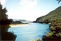
Shimantogawa

Kochi Castle

Road signs in Kochi Prefecture


Web links
Individual evidence
- ↑ Kokudo Chiriin (GSI - Geospatial Information Authority of Japan), 平 成 29 年 全国 都 道 府 県 市区 町 村 別 面積 調 (Nationwide survey of all prefectures and municipalities 2017) , p. 85: 39 Kōchi-ken (Japanese), accessed on 9 December 2018
- ↑ 簡 単 検 索 ・ 詳細 検 索 ・ 検 索 サ ン プ ル , accessed December 9, 2018 (Japanese)
- ↑ e-stat (English), accessed on December 9, 2018
- ↑ e-Stat database , accessed on January 1, 2019 (English)
- ↑ Kōchi Prefectural Parliament : Members by parliamentary group , accessed on August 12, 2019.
- ↑ 2019 高 知 県 知事 選 . In: NHK Senkyo Web. November 25, 2019. Retrieved November 25, 2019 (Japanese).
- ↑ 2019 高 知 県 知事 選 新知 事 に 浜 田氏 野 党 共 闘 の 松本 氏 破 る . In: Kōchi Shimbun . November 25, 2019. Retrieved November 25, 2019 (Japanese).
- ↑ Prefecture Parliament Kōchi: MPs by constituency
- ↑ 統一 地方 選 2019 高 知 県 議 選 各 党 議席 . In: NHK Senkyo Web. April 7, 2019. Retrieved August 12, 2019 (Japanese).
Aichi | Akita | Aomori | Chiba | Ehime | Fukui | Fukuoka | Fukushima | Gifu | Gunma | Hiroshima | Hokkaidō | Hyōgo | Ibaraki | Ishikawa | Iwate | Kagawa | Kagoshima | Kanagawa | Kochi | Kumamoto | Kyoto | Mie | Miyagi | Miyazaki | Nagano | Nagasaki | Nara | Niigata | Ōita | Okayama | Okinawa | Osaka | Saga | Saitama | Shiga | Shimane | Shizuoka | Tochigi | Tokyo | Tokushima | Tottori | Toyama | Wakayama | Yamagata | Yamaguchi | Yamanashi
Coordinates: 33 ° 26 ' N , 133 ° 26' E