
Nara prefecture
|
Nara-ken 奈良 県 |
|
|---|---|
  |
|
| Basic data | |
| Administrative headquarters : | Nara |
| Region : | Kinki |
| Main island : | Honshu |
| Area : | 3,690.94 km² |
| Water content: | 0.5 % |
| Residents : | 1,331,330 (October 1, 2019) |
| Population density : | 361 inhabitants per km² |
| Counties : | 7th |
| Municipalities : | 39 |
| ISO 3166-2 : | JP-29 |
| Governor : | Shōgo Arai |
| Website: | www.pref.nara.jp |
| Symbols | |
| Prefecture flag : |
 |
| Prefecture tree : | Crescent fir |
| Prefecture flower : | Prunus verecunda cv. Antiqua |
| Vogel prefecture : | Rostkehlnachtingall |
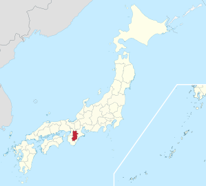
The Nara ( Jap. 奈良県 , Nara-ken ) is a prefecture of Japan . It is located in the Kinki region on the island of Honshu . The seat of the prefecture administration is the city of the same name, Nara .
geography
Nara Prefecture is located in the center of the Kii Peninsula of Honshu. Topographically, the prefecture consists of the Nara basin ( Nara-bonchi ) in the northwest, the Yamato plateau ( Yamato-kōgen ) in the northeast, and the Kii mountains in the south. The highest point is the Hakkyō-ga-take with 1915.2 m.
Significant rivers are the Yamato-gawa and the Yoshino-gawa (Kinokawa).
history
The Yamato Province has been located in what is now the Nara Prefecture since ancient times .
It is certain that Yamato was a political center in the early history of Japan and that in the 3rd and 4th centuries a political power ruled at the foot of Mount Miwa , which united a large part of Japan. However, only a few documents exist from this period. Until it was moved to Heian-kyō ( Kyoto ) in 794 , the capital of Japan was mostly in today's prefecture - in Asuka-kyō ( Asuka ), Fujiwara-kyō ( Kashihara ) and, most recently, Heijō-kyō (Nara). The two historical epochs of the Asuka and Nara times were named after the former and the latter .
In the Meiji Restoration in 1868, the first Nara prefecture was created from areas previously controlled by the Tokugawa ( Bakuryō ) in the Yamato province. When the principalities were abolished in 1871, the prefecture was expanded to include principalities in the province of Yamato that were briefly converted into 15 prefectures . The first Nara Prefecture existed until 1876 when it became part of Sakai Prefecture ; this in turn was incorporated into Osaka Prefecture in 1881 . In 1887, the prefecture of Nara was separated again and has existed since then without any significant change in area. The first prefectural parliament opened its first session in 1888 in Tōdai-ji .
politics
The former national LDP deputy Shōgo Arai has been governor of Nara since 2007 and was re-elected for a fourth term in the unified regional elections in April 2019 . The LDP is the strongest party in the parliament, also elected in the unified regional elections.
In the national parliament , Nara elects one member per election to the council house , after the elections in 2016 and 2019 the Liberal Democrats Iwao Horii and Kei Satō , the number of constituencies in Nara for the House of Representatives was reduced to three for the 2017 election , and with Shigeki Kobayashi , Sanae Takaichi and Taidō Tanose now only represent Liberal Democrats in the prefecture there.
Partnerships
According to the prefecture administration, Nara maintains international partnerships with the Swiss canton of Bern (since 2015), the Korean province of Chungcheong-South (since 2011) and the Chinese province of Shaanxi (since 2011); A declaration on the establishment of a partnership was adopted in 2014 with the Vietnamese province of Phú Thọ .
Administrative division
Since 2006, the prefecture has been divided into 12 independent cities ( Shi ) as well as 15 (district / small) cities ( Chō ) and 12 villages ( Son ). The latter are organized in 7 districts ( Gun ).
By October 2004 there were 50 municipalities, 7 of which were independent cities. Nara , the seat of the prefecture administration, has also been a Chūkakushi ("core city") since 2002 .
In the table below, the districts ( 郡 ) are shown in italics, underneath each (indented) the small towns ( 町 ) and the villages ( 村 ) within them. A dependency between rural district and small town can also be seen in the first three digits of the code (1st column). The independent cities are at the beginning of the table.
| code | Surname | Area (in km²) | population | Population density (inh / km²) |
||
|---|---|---|---|---|---|---|
| Rōmaji | Kanji | 01.10.2017 1 | 01.10.2018 3 | 01/10/2015 2 | ||
| 29201 | Nara- shi | 奈良 市 | 276.94 | 355,350 | 360.310 | 1301.04 |
| 29202 | Yamatotakada- shi | 大 和 高田 市 | 16.48 | 62,489 | 64,817 | 3933.07 |
| 29203 | Yamatokōriyama- shi | 大 和 郡山 市 | 42.69 | 85.405 | 87,050 | 2039.12 |
| 29204 | Tenri- shi | 天理 市 | 86.42 | 65,942 | 67,398 | 779.89 |
| 29205 | Kashihara- shi | 橿 原 市 | 39.56 | 122,422 | 124.111 | 3137.29 |
| 29206 | Sakurai- shi | 桜 井 市 | 98.91 | 55,572 | 57,244 | 578.75 |
| 29207 | Gojō- shi | 五條 市 | 292.02 | 29,161 | 30,997 | 106.15 |
| 29208 | Gose- shi | 御所 市 | 60.58 | 25,457 | 26,868 | 443.51 |
| 29209 | Ikoma- shi | 生 駒 市 | 53.15 | 117,411 | 118.233 | 2224.52 |
| 29210 | Kashiba shi | 香 芝 市 | 24.26 | 78,542 | 77,561 | 3,197.07 |
| 29211 | Katsuragi- shi | 葛 城市 | 33.72 | 37,028 | 36,635 | 1086.45 |
| 29212 | Uda- shi | 宇 陀 市 | 247.50 | 29,236 | 31,105 | 125.68 |
| 29300 | Yamabe-gun | 山 辺 郡 | 66.52 | 3389 | 3674 | 55.23 |
| 29322 | Yamazoe-mura | 山 添 村 | 66.52 | 3389 | 3,674 | 55.23 |
| 29340 | Ikoma-gun | 生 駒 郡 | 51.27 | 76,495 | 77,200 | 1505.75 |
| 29342 | Heguri-cho | 平 群 町 | 23.90 | 18,362 | 18,883 | 790.08 |
| 29343 | Sango-cho | 三 郷 町 | 8.79 | 23,381 | 23,571 | 2681.57 |
| 29344 | Ikaruga- chō | 斑鳩 町 | 14.27 | 27,394 | 27.303 | 1913.31 |
| 29345 | Ando-cho | 安 堵 町 | 4.31 | 7358 | 7443 | 1726.91 |
| 29360 | Shiki-gun | 磯 城 郡 | 31.09 | 46.292 | 47.012 | 1512.13 |
| 29361 | Kawanishi-cho | 川西 町 | 5.93 | 8424 | 8485 | 1430.86 |
| 29362 | Miyake-cho | 三 宅 町 | 4.06 | 6726 | 6836 | 1683.74 |
| 29363 | Tawaramoto-chō | 田 原本 町 | 21.09 | 31,142 | 31,691 | 1502.66 |
| 29380 | Uda-gun | 宇 陀 郡 | 127.34 | 3009 | 3308 | 25.98 |
| 29385 | Soni-mura | 曽 爾 村 | 47.76 | 1431 | 1549 | 32.43 |
| 29386 | Mitsue-mura | 御 杖 村 | 79.58 | 1578 | 1759 | 22.10 |
| 29400 | Takaichi-gun | 高市 郡 | 49.89 | 12,221 | 12,718 | 254.92 |
| 29401 | Takatori-cho | 高 取 町 | 25.79 | 6882 | 7195 | 278.98 |
| 29402 | Asuka- mura | 明日香 村 | 24.10 | 5339 | 5523 | 229.17 |
| 29420 | Kitakatsuragi-gun | 北 葛 城 郡 | 37.68 | 96.192 | 96.507 | 2561.23 |
| 29424 | Kammaki-cho | 上 牧 町 | 6.14 | 21,484 | 22,054 | 3591.86 |
| 29425 | Ōji-chō | 王 寺 町 | 7.01 | 23,733 | 23,025 | 3284.59 |
| 29426 | Kōryō-chō | 広 陵 町 | 16.30 | 33,606 | 33,487 | 2054.42 |
| 29427 | Kawai-cho | 河 合 町 | 8.23 | 17,369 | 17,941 | 2179.95 |
| 29440 | Yoshino-gun | 吉野 郡 | 2054.91 | 38,457 | 41,568 | 20.23 |
| 29441 | Yoshino-cho | 吉野 町 | 95.65 | 6674 | 7399 | 77.35 |
| 29442 | Ōyodo-chō | 大 淀 町 | 38.10 | 17.179 | 18,069 | 474.25 |
| 29443 | Shimoichi-cho | 下 市 町 | 61.99 | 5155 | 5664 | 91.37 |
| 29444 | Kurotaki-mura | 黒 滝 村 | 47.70 | 605 | 660 | 13.84 |
| 29446 | Tenkawa-mura | 天 川村 | 175.66 | 1240 | 1354 | 7.71 |
| 29447 | Nosegawa-mura | 野 迫 川村 | 154.90 | 387 | 449 | 2.90 |
| 29449 | Totsukawa-mura | 十津川 村 | 672.38 | 3224 | 3508 | 5.22 |
| 29450 | Shimokitayama-mura | 下 北 山村 | 133.39 | 799 | 895 | 6.71 |
| 29451 | Kamikitayama-mura | 上 北 山村 | 274.22 | 445 | 512 | 1.87 |
| 29452 | Kawakami-mura | 川 上 村 | 269.26 | 1186 | 1313 | 4.88 |
| 29453 | Higashiyoshino-mura | 東 吉野 村 | 131.65 | 1563 | 1745 | 13.25 |
| Shi-bu (proportion of urban districts) | 市 部 | 1272.23 | 1,064,015 | 1,082,329 | 850.73 | |
| Gun-bu (proportion of counties) | 郡 部 | 2418.70 | 276.055 | 281.987 | 116.59 | |
| 29000 | Nara-ken (Nara Prefecture) | 奈良 県 | 3690.94 | 1,340,070 | 1,364,316 | 369.64 |
swell
1 Area data from 2017
2 Results of the 2015 census
3 Estimated population 2018
Biggest places
| Census year | Residents | |||
|---|---|---|---|---|
| 2015 | 2010 | 2005 | 2000 | |
| Yamatotakada | 64,817 | 68,451 | 70,800 | 73,668 |
| Yamatokōriyama | 87,050 | 89.023 | 91,672 | 94,188 |
| Tenri | 67,398 | 69,178 | 71,152 | 72,741 |
| Kashihara | 124.111 | 125.605 | 124,728 | 125.005 |
| Sakurai | 57,244 | 60,146 | 61.130 | 63,248 |
| Gojo | 30,997 | 34,460 | 37,375 | 35.205 |
| Gose | 26,868 | 30,287 | 32,273 | 34,676 |
| Ikoma | 118.233 | 118.113 | 113,686 | 112,830 |
| Kashiba | 77,561 | 75,227 | 70.998 | 63,487 |
| Katsuragi | 36,635 | 35,859 | 34,985 | —— |
| Uda | 31,105 | 34,227 | —— | —— |
On October 1, 2004 - two small towns merged to form the independent city of Katsuragi .
On January 1, 2006, three small towns and a village merged to form the independent city of Uda .
Population development in the prefecture
| Census year |
Total population |
male population |
female population |
Gender ratio men to 1000 women |
Area in km 2 |
Population density per km 2 |
|---|---|---|---|---|---|---|
| 1920 | 564,607 | 280.383 | 284.224 | 986 | 3730.09 | 151.37 |
| 1925 | 583,828 | 289.770 | 294.058 | 985 | 3730.09 | 156.52 |
| 1930 | 596.225 | 295,456 | 300,769 | 982 | 3688.60 | 161.64 |
| 1935 | 620.471 | 306.011 | 314,460 | 973 | 3688.60 | 168.21 |
| 1940 | 620.509 | 305,681 | 314,828 | 971 | 3688.60 | 168.22 |
| 1945 | 779.685 | 355.351 | 424.334 | 837 | 3688.60 | 211.38 |
| 1950 | 763.883 | 368,863 | 395.020 | 934 | 3687.97 | 207.13 |
| 1955 | 776.861 | 377.961 | 398,900 | 948 | 3692.11 | 210.41 |
| 1960 | 781.058 | 382.494 | 398,564 | 960 | 3692.15 | 211.55 |
| 1965 | 825.965 | 400.353 | 425.612 | 941 | 3692.15 | 223.71 |
| 1970 | 930.160 | 450,668 | 479,492 | 940 | 3692.15 | 251.93 |
| 1975 | 1,077,491 | 523.633 | 553.858 | 945 | 3692.15 | 291.83 |
| 1980 | 1,209,365 | 587,067 | 622.298 | 943 | 3692.15 | 327.55 |
| 1985 | 1,304,866 | 632.955 | 671.911 | 942 | 3692.15 | 353.42 |
| 1990 | 1,375,481 | 663.591 | 711.890 | 932 | 3690.41 | 372.72 |
| 1995 | 1,430,862 | 688.741 | 742.121 | 928 | 3691.09 | 387.65 |
| 2000 | 1,442,795 | 691.098 | 751.697 | 919 | 3691.09 | 390.89 |
| 2005 | 1,421,310 | 676.375 | 744.935 | 908 | 3691.09 | 385.07 |
| 2010 | 1,400,728 | 663,321 | 737.407 | 900 | 3691.09 | 379.49 |
| 2015 | 1,364,316 | 643.946 | 720.370 | 894 | 3690.94 | 369.64 |

Road signs in Nara prefecture


Culture
Important festivals
| date | Firmly | place |
|---|---|---|
| January 1st | Nyōdō festival | Ōmiwa shrine |
| January 4th | Oyumi Hajime Festival | Ōyamato-ji |
| Sunday before the 2nd Monday in January | Yamayaki (grass burning) ceremony | Mount Wakakusa |
| January 23 | Konin-e ceremony | Daian-ji |
| 3 February | Shunie (driving out demons) ceremony | Hōryū-ji |
| 3 February | Demon casting ceremony | Kofuku-ji |
| February 11th | Kigen Fest | Kashihara-jingu |
| 11./12. February | Sand throwing festival | Hirose shrine |
| 14th of February | Dada-oshi ceremony | Hare-dera |
| 1st - 14th March | Shunie (water drawing) ceremony | Tōdai-ji |
| March 13th | Saru festival | Nara ; Kasuga Taisha |
| 22.-24. March | Oeshiki ceremony | Hōryū-ji |
| March 30th – 5th April | Flower offering ceremony | Yakushi-ji |
| April 1st | Chan-chan festival | Ōyamato-ji |
| 1-7 April | Hina-e-shiki ceremony | Hokke-ji |
| April 8th | Oitamatsu ceremony | Shin-Yakushi-ji |
| 2nd weekend in April | Ochamori (Great Tea) Ceremony | Saidai-ji |
| May 14th | Procession of the 25 Bodhisattvas | Kitakatsuragi , Taima-dera |
| May 19th | Uchiwa-maki (fan throwing) ceremony | Toshodai-ji |
| 5th-7th June | Kaisan-ki (ceremony for the founder's death) | Toshodai-ji |
| 17th of June | Saigusa (lily) festival | Isakawa-ji |
| June 30th | Shinhen Togyo ceremony | Isonokami-jingū |
| 7th of July | Frog hopping ceremony | Yoshino ; Kinpusen-ji |
| July 28th | Degyo-e - ceremony | Tōdai-ji |
| August 7th | Ritual cleaning of the Buddha statue | Tōdai-ji |
| 14./15. August | Illuminated Lantern Ceremony | Nara ; Kasuga Taisha |
| 23/24 August | Jizo-eshiki ceremony | Yamatokoriyama , Yata-dera |
| Full moon in September | Uneme festival | Uneme-ji |
| Full moon in September | Moon viewing | Toshodai-ji |
| Sundays and bank holidays in October | Cutting the deer antlers | Nara ; Nara Park at Kasuga Taisha |
| October 11th | Kakitsu Festival | Sakurai ; Tanzan shrine |
| October 12th | Daimoku-take ceremony | Hatchu-ji |
| 15th October | Togyo ceremony | Isonokami-jingū |
| October, 16th | Annual autumn festival | Niukawakami Nakasha |
| 3rd Sunday in October | Ball game festival | Sakurai ; Tanzan shrine |
| 2nd Sunday in November | Jion-e ceremony | Yakushiki-ji or Kofuku -ji |
| 14th November | Sake festival | Ōmiwa shrine |
| 15-18 December | Kasuga Wakamiya On-matsuri | Nara ; Kasuga Taisha |
Web links
Individual evidence
- ↑ Nara Prefecture for children: な ら け ん は い つ で き た の か な
- ↑ Nara Prefectural Parliament : Members by parliamentary group , accessed on August 9, 2019.
- ↑ Nara Prefectural Administration, International Office (kokusai-ka) : 海外 と の 友好 交流 に つ い て , accessed on March 26, 2019.
- ↑ Kokudo Chiriin (GSI - Geospatial Information Authority of Japan), 平 成 29 年 全国 都 道 府 県 市区 町 村 別 面積 調 (Nationwide survey of all prefectures and municipalities 2017) , pp. 71: 29 Nara-ken (Japanese), accessed on 1 January 2019
- ↑ e-stat (English), accessed on January 1, 2019
- ↑ 簡 単 検 索 ・ 詳細 検 索 ・ 検 索 サ ン プ ル , accessed January 1, 2019 (Japanese)
- ↑ e-Stat database , accessed on January 1, 2019 (English)
Aichi | Akita | Aomori | Chiba | Ehime | Fukui | Fukuoka | Fukushima | Gifu | Gunma | Hiroshima | Hokkaidō | Hyōgo | Ibaraki | Ishikawa | Iwate | Kagawa | Kagoshima | Kanagawa | Kochi | Kumamoto | Kyoto | Mie | Miyagi | Miyazaki | Nagano | Nagasaki | Nara | Niigata | Ōita | Okayama | Okinawa | Osaka | Saga | Saitama | Shiga | Shimane | Shizuoka | Tochigi | Tokyo | Tokushima | Tottori | Toyama | Wakayama | Yamagata | Yamaguchi | Yamanashi
Coordinates: 34 ° 34 ' N , 135 ° 46' E