Bolandoz
| Bolandoz | ||
|---|---|---|
|
|
||
| region | Bourgogne-Franche-Comté | |
| Department | Doubs | |
| Arrondissement | Besançon | |
| Canton | Ornans | |
| Community association | Loue-Lison | |
| Coordinates | 47 ° 1 ' N , 6 ° 7' E | |
| height | 590-910 m | |
| surface | 12.21 km 2 | |
| Residents | 372 (January 1, 2017) | |
| Population density | 30 inhabitants / km 2 | |
| Post Code | 25330 | |
| INSEE code | 25070 | |
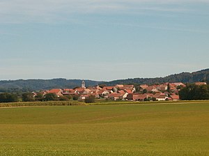
 View of Bolandoz |
||
Bolandoz is a commune with 372 inhabitants (as of January 1 2017) in Doubs in the region Bourgogne Franche-Comté .
geography
Bolandoz is located at 650 m above sea level, about ten kilometers south of Ornans and 25 kilometers south-southeast of the city of Besançon (as the crow flies). The village extends in the Jura , on the southern edge of the Amancey plateau, which extends between the valleys of Loue and Lison , at the northern foot of the ridge of Le Châtelet.
The area of the 12.21 km² municipal area covers a section of the French Jura. The northern part of the area is occupied by the Amancey plateau, which is an average of 650 m and consists mainly of meadowland. The plateau rises gradually to the south. The community area extends southwards on the broad ridge, which forms an anticline in geological and tectonic terms and is oriented in the direction of west-southwest-east-northeast in accordance with the direction of the Jura in this region. The ridge includes the heights of Le Châtelet (at 910 m the highest point of Bolandoz) and Malveau . The ridge is divided by two erosion valleys, including the Val du Bas des Mais north of the Malveau . However, both streams seep away as soon as they step out onto the Amancey plateau. Otherwise, the entire area has no surface watercourses because the rainwater seeps into the karstified subsoil.
Neighboring municipalities of Bolandoz are
- Amancey , Flagey and Silley-Amancey to the north,
- Reugney to the east,
- Levier with Levier and Labergement-du-Navois in the south,
- Déservillers in the west.
history
Since the 13th century Bolandoz formed its own small rule, which belonged to a local noble family and was under the sovereignty of the Scey rule. In the 14th century, Jean de Bolandoz exercised a reign of terror over his area and was the author of various attacks and looting in the neighboring rule. After his execution his property passed directly to the Counts of Burgundy. Together with Franche-Comté , the village came to France with the Peace of Nijmegen in 1678. In 1893 and 1955 Bolandoz was hit by serious village fires. Since 1993, Bolandoz has been a member of the Loue-Lison community of 19 localities .
Attractions
The three-aisled Saint-Georges church was built in 1723 and is richly decorated , including statues from the 15th and 18th centuries. To the west of the village is the Bonne-Aventure field chapel with the Notre-Dame des Aventures statue from the 15th century.
Various village fountains from the 19th century are also noteworthy, in particular the Fontaine Marianne, which was built according to plans by the architect Sauterey.
population
| Population development | |
|---|---|
| year | Residents |
| 1962 | 322 |
| 1968 | 294 |
| 1975 | 290 |
| 1982 | 294 |
| 1990 | 316 |
| 1999 | 299 |
| 2006 | 332 |
| 2016 | 379 |
With 372 inhabitants (January 1, 2017), Bolandoz is one of the small communities in the Doubs department. After the population had decreased markedly in the first half of the 20th century (510 people were counted in 1881), only minor fluctuations have been recorded since the early 1970s.
Economy and Infrastructure
Until well into the 20th century, Bolandoz was primarily a village characterized by agriculture (arable farming, cattle breeding) and forestry. In addition, there are now some local small businesses. In the meantime, the village has also turned into a residential community. Many workers are commuters who work in the larger towns in the area.
The village is located off the major thoroughfares on the D492 department road, which leads from Ornans to Salins-les-Bains . Further road connections exist with Amancey and Reugney.


