Lison (river)
| Lison | ||
|
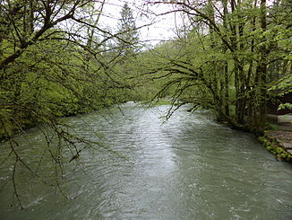
The Lison southeast of Cussey-sur-Lison |
||
| Data | ||
| Water code | FR : U2610580 | |
| location | France , Bourgogne-Franche-Comte region | |
| River system | Rhône | |
| Drain over | Loue → Doubs → Saône → Rhône → Mediterranean | |
| source | in the municipality of Nans-sous-Sainte-Anne 46 ° 57 ′ 56 ″ N , 6 ° 0 ′ 41 ″ E |
|
| Source height | approx. 400 m | |
| muzzle | in the municipality of Châtillon-sur-Lison in the Loue coordinates: 47 ° 4 ′ 20 ″ N , 5 ° 59 ′ 14 ″ E 47 ° 4 ′ 20 ″ N , 5 ° 59 ′ 14 ″ E |
|
| Mouth height | 290 m | |
| Height difference | approx. 110 m | |
| Bottom slope | approx. 4.4 ‰ | |
| length | 25 km | |
|
The Lison about 150 m below its source |
||
The Lison is a river in France in the Doubs department in the Bourgogne-Franche-Comté region . It rises from a rich karst spring in the municipality of Nans-sous-Sainte-Anne and flows into the Loue from the left and south at Châtillon-sur-Lison .
geography
Source you Lison
The Source du Lison (dt. Source of Lison ) is a strong karst spring in Nans-sous-Sainte-Anne , still 600 l / s of water on average 5,350 l / s and even in drought almost overwhelmed . The spring water flows out of a huge cave portal below a rock wall and then falls down a waterfall. The source is fed underground partly by the Ruisseau Château-Renaud , partly by the Lizon Supérieur , both of which disappear from the surface and seep away further up in the catchment area.
course
The Lison generally drains north and flows into the Loue after 25 kilometers in the municipality of Châtillon-sur-Lison from the left . The catchment area of the Lison is a nature reserve as part of the Natura2000 project and registered under the codes FR4301297 and FR4312011.
Tributaries
The most important tributary of the Lison is the Todeur , which flows into it from the left at Myon .
Places on the river
Web links
- La Source du Lison (French)
- Natura2000 area Lisontal (habitats, flora, fauna) (French)
- Natura2000 area Lisontal (birds) (French)
- Information about the river on kajaktour.de


