
Jallerange
| Jallerange | ||
|---|---|---|
|
||
| region | Bourgogne-Franche-Comté | |
| Department | Doubs | |
| Arrondissement | Besançon | |
| Canton | Saint Vit | |
| Community association | Val Marnaysia | |
| Coordinates | 47 ° 15 ' N , 5 ° 43' E | |
| height | 198-320 m | |
| surface | 5.41 km 2 | |
| Residents | 260 (January 1, 2017) | |
| Population density | 48 inhabitants / km 2 | |
| Post Code | 25170 | |
| INSEE code | 25317 | |

|
||

Jallerange is a French municipality with 260 inhabitants (as of January 1 2017) in Doubs in the region Bourgogne Franche-Comté .
geography
Jallerange is located at an altitude of 220 m above sea level, about 24 kilometers west of the city of Besançon (as the crow flies). The village extends on the southern edge of the wide valley of the Ognon , on the northern edge of the hilly landscape between the valleys of Ognon and Doubs and at the north foot of the Bois de Ruppe. Jallerange is the westernmost municipality in the Doubs department.
The area of the 5.41 km² large municipal area includes a section of the lower Ognontal. The northern border runs along the Ognon, which flows here with numerous meanders through an approximately three kilometer wide valley floor to the west. From the course of the Ognon river, the municipal area extends southward over the alluvial plain , which is an average of 200 m, which consists mainly of arable and meadow land and is occupied in the east by the forest area of the Bois d'Aval . Further south, the terrain gradually rises to the crests of Moutherot and Bois de Ruppe in the gently undulating landscape between the Ognon and Doubs. These hills form the northeastern foothills of the Massif de la Serre . Jallerange's highest point is reached in the Bois de Ruppe at 320 m.
Neighboring municipalities of Jallerange are Sornay and Chenevrey-et-Morogne in the north, Courchapon in the east, Le Moutherot and Étrabonne in the south and Pagney in the west.
history
The municipality of Jallerange was populated very early. There was a Roman country house on the parish grounds. Together with Franche-Comté, Jallerange finally came to France with the Peace of Nijmegen in 1678. In 1972, the municipality expanded through the incorporation of Courchapon and Le Moutherot. However, both places regained their independence in 1981 and 1985, respectively. Today Jallerange is a member of the Val Marnaysien municipal association .
Attractions
The Assumption Church in Jallerange was built in the 18th century. Its furnishings include the remarkable wooden statue of Notre-Dame-des-Ermites (also from the 18th century). The castle, which is surrounded by a French garden, was built in 1751.

Jallerange Castle
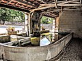
upper lavoir

lower lavoir

Assumption Church
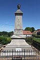
Fallen memorial

.jpg)
.jpg)


population
| Population development | |
|---|---|
| year | Residents |
| 1962 | 217 |
| 1968 | 184 |
| 1975 | 170 |
| 1982 | 192 |
| 1990 | 145 |
| 1999 | 169 |
| 2005 | 206 |
| 2016 | 254 |
With 260 inhabitants (as of January 1, 2017) Jallerange is one of the small communities in the Doubs department. After the population had decreased significantly in the first half of the 20th century (306 people were still counted in 1891), a slight increase in population was only recorded since the beginning of the 1990s.
Economy and Infrastructure
Until well into the 20th century, Jallerange was mainly a village characterized by agriculture (arable farming, fruit growing and cattle breeding) and forestry. In addition, there are now some local small businesses. In the meantime, the village has also turned into a residential community. Many employed people are commuters who work in the larger towns in the area and in the Besançon agglomeration.
The village is located off the major thoroughfares on a department road that leads from Marnay to Thervay . The closest connection to the A36 motorway is around twelve kilometers away. Other road connections exist with Sornay, Le Moutherot and Lantenne-Vertière.