
Sulzbach / Saar
| coat of arms | Germany map | |
|---|---|---|
_COA.svg)
|
Coordinates: 49 ° 18 ' N , 7 ° 3' E |
|
| Basic data | ||
| State : | Saarland | |
| County : | Regional association Saarbrücken | |
| Height : | 233 m above sea level NHN | |
| Area : | 16.12 km 2 | |
| Residents: | 16,334 (Dec. 31, 2019) | |
| Population density : | 1013 inhabitants per km 2 | |
| Postal code : | 66280 | |
| Area code : | 06897 | |
| License plate : | SB | |
| Community key : | 10 0 41 518 | |
| LOCODE : | DE SDR | |
| City structure: | 6 districts | |
City administration address : |
Sulzbachtalstr. 81 66280 Sulzbach / Saar |
|
| Website : | ||
| Mayor : | Michael Adam ( CDU ) | |
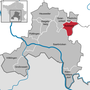
| Location of the city of Sulzbach / Saar in the Saarbrücken regional association | ||
  |
||


_Ehemaliges_Herrenhaus_Appolt.JPG)
_Ansicht_2012-09-02.JPG)
Sulzbach / Saar ( ) is a city in the Saarland regional association Saarbrücken .
geography
location
The city is located in the upper Sulzbachtal in the area of the Saarkohlenwald , about ten kilometers northeast of Saarbrücken and about four kilometers northwest of St. Ingbert .
Districts
The districts of Altenwald , Brefeld , Hühnerfeld , Neuweiler , Schnappach and Sulzbach Mitte, the original town center, belong to Sulzbach / Saar .
Neighboring communities
In the south the city of Sulzbach borders on the state capital Saarbrücken, in the west on the municipality Quiigart and in the north on the city of Friedrichsthal , which all belong to the Saarbrücken regional association. To the east, Sulzbach borders the medium-sized town of St. Ingbert, which is located in the Saarpfalz district .
climateThe annual precipitation is 922 mm and is thus in the upper third of the values recorded by the measuring points of the German Weather Service . Over 79% indicate lower values. The driest month is April; it rains most in December. In the wettest month there is around 1.6 times more rain than in the driest month. The seasonal fluctuations in precipitation are in the lower third. In only 24% of all places, the monthly precipitation fluctuates less. |

history
The village Sulzbach was first mentioned in a document in 1346. There is no information about the exact time of the foundation. The naming after the Sulzbach flowing through the place, in contrast to other place name types, does not allow a clear chronological assignment. Nevertheless, it can be ruled out with a high degree of certainty that Sulzbach was founded in the early Middle Ages, as settlement names derived from water bodies only became popular with the great clearing of the High Middle Ages . For this reason one can assume that Sulzbach was founded in the 12th or 13th century, i.e. in the High Middle Ages. This assumption is also supported by the settlement geography . The location in the Saarkohlenwald, one of the most sterile areas of the Saarland, hardly gave any incentives to settle. From Dudweiler, which lies at the exit of the Sulzbachtal and was first mentioned in 977, the settlement moved reluctantly up the valley. Friedrichsthal, located at the Sulzbach springs, was only founded in 1723.
In the late Middle Ages, the sources of income for the residents of Sulzbach lay in wild, disordered coal graves , as evidenced by reports from 1462. With the final transfer to the possession of the County of Nassau-Saarbrücken in 1549, salt production began in Sulzbach , which lasted until 1736 when the unprofitable salt works was closed.
The Thirty Years War (1618–1648) initially did not affect Sulzbach, as the Counts of Saarbrücken initially knew how to stay out of the conflict. But already in 1623 the plague broke out in the Sulzbachtal for the first time , and in 1627/1628 the county of Saarbrücken, and with it Sulzbach, suffered from the rampant imperial and scratchy troops billeted here (Count Johann Philipp Craz). After Saarbrücken had entered into an alliance with the Swedes , it came to a catastrophe in 1635 when the Croatian soldiers of the imperial lieutenant general and Feldzeugmeister Gallas devastated the country and the village of Sulzbach perished. According to a report by the Saarbrücken rent master Klicker at the end of 1635, there were only two residents left in Sulzbach.
It would take 93 years before Sulzbach was rebuilt. The repopulation of the village began in 1728. In the course of the 18th century, industrialization was initiated in Sulzbach with the iron smelter built on the “Schmelz” in 1765 . From the middle of the 19th century, hard coal mining became the most important source of income in Sulzbach for over 100 years , which gained enormous momentum with the construction of the railway in 1852. Another important economic factor in the 19th century was the glass industry . From the beginning of the 19th century until 1936, the boil-proof and light-resistant Prussian or Berlin blue , which was used to dye fabrics, was produced in the Sulzbach “ blue factory”.
During the League -Mandats on the Saar (1920-1935) was the first in Sulzbach 1920 Domanialschulen established.
In 1866 Sulzbach received an independent municipal administration, and in 1939 a municipal coat of arms was awarded. 1946 Sulzbach was raised to the city.
Incorporations
In the course of the regional and administrative reform in Saarland , the St. Ingbert district of Schnappach (formerly called "St. Ingberter Grube") came to the city of Sulzbach with effect from January 1, 1974.
Population development
| date | Residents |
|---|---|
| December 31, 2005 | 18,232 |
| March 31, 2006 | 18,204 |
| June 30, 2006 | 18.191 |
| September 30, 2006 | 18,172 |
| December 31, 2010 | 17,452 |
| December 31, 2012 | 17,300 |
| December 31, 2015 | 16,215 |
politics
Municipal council
The city council of the city of Sulzbach / Saar consists of 33 members. He was elected by the citizens of the city on May 26, 2019.
_Rathaus.JPG)
mayor
- 1946–1956: Fritz Schneider
- 1956–1966: Wolfgang Müller
- 1967-1977: Richard Bellon
- 1977–1982: Hans Joachim Lissmann
- 1982–1992: Ulf Huppert (FDP)
- 1992–2010: Hans-Werner Zimmer (SPD)
- since October 1, 2010: Michael Adam (CDU)
In the runoff election for the office of mayor on October 11, 2009, Michael Adam (CDU) was able to prevail against the SPD candidate Kalle Christmann with 59.4% of the votes cast.
coat of arms
The coat of arms was approved on August 18, 1946.
Blazon : "In blue a silver left-hand wave sloping bar, the silver gold-stemmed badges of mining, mallets and iron crossed at the top right."
The coat of arms indicates the name of the city with the wavy bar. The Sulzbach is fed from salty springs ("Sulze"). Mallets and iron indicate the three coal mines in the urban area, the colors blue and silver of the coat of arms, according to the official justification, to the earlier affiliation to Nassau-Saarbrücken, which, however, are correctly the colors of the Saarbrücken-Commercy.
The coat of arms was designed by Lothar Högel.
Town twinning
- The Italian partner municipality of Sulzbach / Saar has been Ravanusa ( Sicily ) since 2000 . A visible testimony to the partnership on the German side is the renaming of the market square to "Ravanusa Platz". On the Italian side, a square was built in "Via S. Lauricella" on which the coal wagon sent from Sulzbach stands.
- Bassila in Benin ( Donga Department, West Africa ) has been another twin town since 2005 .
- Arc-et-Senans has also been a twin town in the French region of Bourgogne-Franche-Comté since 2014 .
Culture and sights

.jpg)
In the forest between Sulzbach and Dudweiler there is the natural monument “ Burning Mountain ” in a gorge known as the “Klamme ”. According to tradition, a coal seam near the day caught fire here in the 1660s. Johann Wolfgang von Goethe visited the Burning Mountain in 1770, a memorial plaque reminds of this. He wrote about this visit in the 10th book of his memoirs, Poetry and Truth .
Buildings
- The historic salt houses - "Auf der Schmelz", consisting of the salt fountain house (built in 1730) and the so-called Salzherrenhaus.
- Listed residential and commercial buildings in the inner city area in Sulzbachtalstrasse. The z. Some of the restored houses with magnificent facades in different styles of historicism were built between 1875 and 1910.
- The town hall in Sulzbachtalstrasse consists of an older, two-storey late classicist building , built in 1867, and a four-storey extension in the neo-renaissance style with a richly structured sandstone facade added in 1903/1904 .
- The district court in Vopeliusstraße, whose facade of the building erected in 1913 is reminiscent of baroque palace buildings from the 17th / 18th centuries. Century oriented.
- The Catholic parish church of All Saints , the 1927-1929 designed by the Trier architect Peter Marx as a barrel-vaulted hall church with powerful multi-storey bell tower in brick construction was erected and regionally among the first-tier buildings.
- The Protestant parish church - "Auf der Schmelz", which was built in 1852–1854 according to the plans of the Berlin architect C. Rüger as the first neo-Gothic church on the Saar. 1897–1998 was expanded by the Saarbrücken architect Heinrich Güth.
- The Sulzbach train station, built between 1938 and 1939 as a two-storey and single-storey clinker building complex in place of a previous half-timbered building, has a listed wooden ceiling in the entrance hall.
- The former Appolt manor , a two-storey baroque building with twelve window axes, built in 1792 and later expanded. It served 1830–1908 as a mansion for the Appolt family, the owners of the “blue factory”.
- The Appolt burial chapel is located to the east behind the AWO retirement home. It is a Gothic-oriented chapel with a semicircular apse, built around 1900, which served as a burial place for the Sulzbach entrepreneurial family Appolt.
- The Protestant church in the Altenwald district , which was built in the neo-Romanesque style as a prayer room in brick construction from 1891 to 1893 and expanded in 1894 to include the choir and in 1896/1897 to include the church tower. The extreme inclination of the tower caused by the subsidence of the pits led to the name "Leaning Tower of Altenwald".
- The Catholic parish church of the Sacred Heart of Jesus in the Altenwald district, which was built in 1910/11 as a three-aisled basilica with a three-sided polygonal choir based on the design by Saarbrücken architect Moritz Gombert.
- The Catholic parish church of St. Marien in the Hühnerfeld district is a striking red brick building with brightly contrasted plastered surfaces from 1910.
- The Catholic branch church of St. Pius in the Brefeld district, which was originally built in 1898/99 as a horse stable for the cross grave shafts and converted into a church at the end of the 1950s.
Green spaces
From the Protestant church “Auf der Schmelz” parallel to Sulzbachtalstraße, the city park, which was expanded in 1960, extends in a westerly direction . Its origin goes back to the extensive park of the Villa Vopelius . In the course of 2017, the park was fundamentally redesigned. As part of this measure, the Sulzbach was renatured as an ecological replacement measure for the planned renovation of the nearby Maybach mine dump and made the focus of the park. In relation to the history of the city of Sulzbach, the city park has been called the Salinenpark ever since. This also creates a connection to the salt fountain ensemble in the immediate vicinity .
Economy and Infrastructure
_Bahnhof.JPG)
Commercial space was made available in the former slaughterhouse (now called BauWerkStadt).
Major employers include the Sulzbach Knappschaftskrankenhaus and the Hydac Group, which is based in Sulzbach. A large employer was the Hirschbach central workshop of RAG Deutsche Steinkohle AG , which was closed as a result of the withdrawal from hard coal mining in Saarland.
The Fraunhofer Institute for Biomedical Technology and its spin-off BioKryo GmbH have their headquarters in Sulzbach .
A large event building, the AULA, offers a gallery, stage and ballroom and is architecturally worth seeing. The “Eugen-Helmlé-Forum” contained therein and a sculpture honor the translator who lived in the town for a long time.
traffic
Sulzbach is connected to the national road network via the federal motorway 623 ( Friedrichsthal - Saarbrücken ).
Sulzbach is located on the Nahe Valley Railway and has direct connections to Saarbrücken and Mainz via regional train or regional express .
Personalities
sons and daughters of the town
- Carl Friedrich Euler (1823–1891), engineer, founder of the VDI
- Robert Hans Wentzel (1878–1970), university professor for railway construction and rector of the RWTH Aachen
- Otto Brauneck (born February 27, 1896; † July 26, 1917 near Zonnebeke), fighter pilot, member of the Richthofen fighter squadron
- Otto Häusser (1905–1979), sculptor
- Heinrich Brenner (1908–1986), resistance fighter
- Adam Berberich (1914–2001), politician (SPD), member of the state parliament
- Richard Eberle (1918–2001), visual artist and art educator
- Wilhelm Gehrlein (1920–1985), President of the Constitutional Court and Higher Regional Court
- Reinhard Koch (1920–2009), economist and politician, Minister of the Saarland
- Karl Wolfskeil (1921–2000), politician (SPD), member of the state parliament
- Ludwig Harig (1927–2018), writer
- Rudi Assauer (1944–2019), football player and manager
- Sabine Blank (* 1984), soccer player
People who worked in Sulzbach
- Paul Guthörl (1895–1963), geologist and paleontologist
- Eugen Helmlé (1927–2000), writer and translator
- Fritz Zolnhofer (1896–1965), painter (main motif “Working world of coal and steel”); An art prize (2001), donated by the city of Sulzbach and awarded annually to regional painters, was named after him.
literature
- Karl Ludwig Jüngst and Dieter Staerck (eds.): Sulzbach / Saar with Altenwald, Brefeld, Hühnerfeld, Neuweiler, Schnappach, Eine Stadt im Wandel der Zeiten, Sulzbach 1993.
- Ernst Klein: History of the Saarland coal mine Sulzbach-Altenwald (1841-1932) (publications of the Commission for Saarland State History and Folk Research 16), Saarbrücken 1987.
- Hans-Günter Reitz: Sulzbach. Socio-geographical structure of a former mining town in Saarland. (Publications of the Institute for Regional Studies in Saarland, Volume 22). Saarbrücken 1975, ISBN 3-923877-22-6 .
Web links
- City of Sulzbach / Saar
- Literature about Sulzbach / Saar in the Saarland Bibliography
- The Sulzer
- ( Page no longer available , search in web archives: Sulzbacher Umschau )
- Link catalog on the subject of Sulzbach / Saar at curlie.org (formerly DMOZ )
Individual evidence
- ↑ Saarland.de - Official population figures as of December 31, 2019 (PDF; 20 kB) ( help ).
- ↑ Sulzbach's beginnings at: www.sulzbach-saar.de , accessed on November 3, 2012.
- ↑ a b The historical sources of acquisition at: www.sulzbach-saar.de , accessed on November 3, 2012.
- ↑ deutsche-biographie.de
- ^ Downfall in the Thirty Years' War at: www.sulzbach-saar.de , accessed on November 3, 2012.
- ↑ Arnold Ilgemann: "French schools" - The French Domanialschulen in the League of Nations. (PDF) MELUSINE - Literary Society Saar-Lor-Lux-Elsass eV , June 22, 1993, accessed on September 27, 2019 (lecture manuscript).
- ↑ Important historical data at: www.sulzbach-saar.de , accessed on November 3, 2012.
- ^ Federal Statistical Office (ed.): Historical municipality directory for the Federal Republic of Germany. Name, border and key number changes in municipalities, counties and administrative districts from May 27, 1970 to December 31, 1982 . W. Kohlhammer, Stuttgart / Mainz 1983, ISBN 3-17-003263-1 , p. 807 .
- ↑ a b The regional returning officer of the Saarland
- ^ Christian Friedrich Habel: Contributions to the natural history and economy of the Nassau countries. Dessau 1784, p. 16.
- ↑ City walk. at: www.sulzbach-saar.de , accessed on November 3, 2012.
- ↑ The Sulzbach is being redesigned to be close to nature, the Salinenpark as a place to stay is significantly upgraded at: http://landschaftsagenturplus.de , / accessed on July 17, 2017
- ↑ AULA
Altenwald | Brefeld | Chicken field | Neuweiler | Schnappach | Sulzbach