Brefeld (Sulzbach / Saar)
|
Brefeld
City of Sulzbach / Saar
Coordinates: 49 ° 18 ′ 41 ″ N , 7 ° 3 ′ 10 ″ E
|
||
|---|---|---|
| Height : | 276–299 m above sea level NN | |
| Area : | 1.09 km² | |
| Residents : | 440 (May 2016) | |
| Population density : | 406 inhabitants / km² | |
| Postal code : | 66280 | |
| Area code : | 06897 | |
|
Location of Brefeld in Saarland |
||
Brefeld is a district of Sulzbach / Saar in the Saarbrücken regional association , Saarland .
Brefeld is located in the northwest of the city. State road 126 runs on the eastern edge of the smallest district .
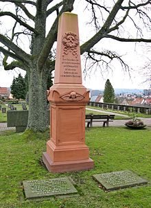
In 1872 the cross trench shafts were dug at the current Brefeld location . In 1888 there was a firedamp explosion in the Kreuzgraben mine, in which 41 miners were killed. In 1898 the Kreuzgraben pit and the district were renamed after the Prussian Minister for Trade and Commerce Ludwig Brefeld . The first houses were built just two years later. The Brefeld mine is no longer in operation.
See also
Web links
Individual evidence
- ↑ Social Demographic data base www.sulzbach-saar.de, accessed on 11 October 2018
- ↑ Bruno Alt: Police and crime in Quiigart . Ed .: Municipality of Quiigart. 2nd Edition. Quiersche 1997, p. 16 .


