Gremersdorf
| coat of arms | Germany map | |
|---|---|---|

|
Coordinates: 54 ° 20 ' N , 10 ° 56' E |
|
| Basic data | ||
| State : | Schleswig-Holstein | |
| Circle : | Ostholstein | |
| Office : | Oldenburg-Land | |
| Height : | 19 m above sea level NHN | |
| Area : | 45.76 km 2 | |
| Residents: | 1507 (Dec. 31, 2019) | |
| Population density : | 33 inhabitants per km 2 | |
| Postcodes : | 23758, 23779 | |
| Area code : | 04361 | |
| License plate : | OH | |
| Community key : | 01 0 55 015 | |
| LOCODE : | DE 64H | |
| Office administration address: | Behind the Höfe 2 23758 Oldenburg in Holstein |
|
| Website : | ||
| Mayor : | Henning Pries ( CDU ) | |
| Location of the municipality of Gremersdorf in the Ostholstein district | ||
Gremersdorf is a municipality in the Ostholstein district in Schleswig-Holstein . The municipality is bordered by the city of Heiligenhafen from the north , the municipality of Neukirchen to the east, the city of Oldenburg in Holstein to the south and the Baltic Sea to the northwest . There are 13 villages and four estates in the municipality. The municipality has existed in its current form since 1968. The villages of Dazendorf , Kembs , Neuratjensdorf , Sulsdorf and Teschendorf as well as the district of Altgalendorf are located in the municipality. The four estates in the municipality are Seegalendorf, Putlos, Johannistal and Bankendorf. The complete list of the districts: Altgalendorf, Bankendorf, Bollbrügge, Dazendorf, Friedrichstal, Giddendorf, Goldkamp, Gremersdorf, Jahnshof, Johannistal, Kembs, Nanndorf, Neuratjensdorf, Neuseegalendorf, Neuteschendorf, Rossee, Seegalendorf, Sulsdorf, Techelwitz , Teschendorf, Wandelwitz .
history
The name Gremersdorf is derived from Gremerstorpe. This means village of Grimhari, Grimheri, Grimher, Grimer. Gremersdorf was founded in 1377 by the six brothers v. Siggen sold to the city council of Kiel for the benefit of the Heiligengeist and St. Jürgen hospitals. At the beginning of the following century the village had eight hooves.
Teschendorf was the northernmost of the chapter villages of the Lübeck cathedral chapter .
Gut Seegalendorf
Gut Seegalendorf was founded towards the end of the 16th century. The estate, like the Putlos estate to which it initially belonged, was owned by the Rantzau family , from the middle of the 18th century owned by the von Rumohr family . The mansion was built towards the end of the 18th century. The original main building was a one-story half - timbered house , to which two cavalier wings made of red brick were attached. While the cavalier wing still stands today, the manor house was replaced by a late classicist building in 1839 .
The Seegalendorf estate is used for agriculture today and breeds Shetland ponies .
Good putlos
The former Putlos estate ⊙ was located in the restricted area of the Putlos military training area established in 1935 .
economy
The municipality is dominated by agriculture, with rapeseed and grain cultivation predominating. However, there are also some small businesses.
There are two wind farms in the municipality.
Road traffic
Gremersdorf is located on the A1 with a total of two junctions. The A 1 and B 207 are around 15 km from the Fehmarnsund Bridge . Along this road runs the European route 47 and the " Vogelfluglinie ", which after about 28 km reaches the ferry port Puttgarden on Fehmarn with a ferry line to Denmark.
Highway 60 runs through the south.
politics
Community representation
The 2018 election resulted in the following:
coat of arms
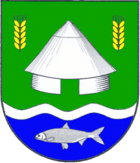
Blazon : “Divided by green and blue, lowered by a narrow silver wavy bar. Above a silver round barn , each accompanied by a golden ear of corn on the left and right, and below a silver fish. "
literature
- Deert Lafrenz: manors and manors in Schleswig-Holstein . Published by the State Office for Monument Preservation Schleswig-Holstein, 2015, Michael Imhof Verlag Petersberg, 2nd edition, ISBN 978-3-86568-971-9 , p. 536.
Web links
Individual evidence
- ↑ North Statistics Office - Population of the municipalities in Schleswig-Holstein 4th quarter 2019 (XLSX file) (update based on the 2011 census) ( help on this ).
- ↑ Schleswig-Holstein topography. Vol. 3: Ellerbek - Groß Rönnau . 1st edition Flying-Kiwi-Verl. Junge, Flensburg 2003, ISBN 978-3-926055-73-6 , p. 295 ( dnb.de [accessed April 26, 2020]).
- ↑ Schleswig-Holstein's municipal coat of arms


