
Office Oldenburg-Land
| coat of arms | Germany map | |
|---|---|---|

|
Coordinates: 54 ° 18 ' N , 10 ° 53' E |
|
| Basic data | ||
| State : | Schleswig-Holstein | |
| Circle : | Ostholstein | |
| Area : | 212.98 km 2 | |
| Residents: | 9226 (Dec. 31, 2019) | |
| Population density : | 43 inhabitants per km 2 | |
| License plate : | OH | |
| Office key : | 01 0 55 5543 | |
| Office structure: | 6 municipalities | |
| Office administration address : |
Behind the Höfe 2 23758 Oldenburg i. H. |
|
| Website : | ||
| Head of Office : | Bernd Bruhn ( CDU ) | |
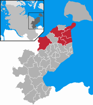
| Location of the Oldenburg-Land office in the Ostholstein district | ||
  |
||

In the Oldenburg-Land office is an office in the Ostholstein district in Schleswig-Holstein . It is located east and west of Oldenburg in Holstein and borders in the north on Heiligenhafen and the Baltic Sea , in the west on the Plön district and the Baltic Sea, in the south on the Ostholstein-Mitte and Grube offices , and in the east on the Baltic Sea.
Official municipalities
history
On April 1, 1970, the office was formed as the State of Oldenburg with the communities of Göhl, Gremersdorf, Heringsdorf and Neukirchen. On April 1, 1977, the Wangels community joined the office, which was then renamed the Oldenburg-Land office . On January 1, 2008, the community of Großenbrode gave up its freedom of office and joined the office.
Web link
Individual evidence
- ↑ North Statistics Office - Population of the municipalities in Schleswig-Holstein 4th quarter 2019 (XLSX file) (update based on the 2011 census) ( help on this ).
Lensahn | Oldenburg-Land | Ostholstein-Mitte
cross-district: Großer Plöner See