
Wangels
| coat of arms | Germany map | |
|---|---|---|

|
Coordinates: 54 ° 16 ' N , 10 ° 46' E |
|
| Basic data | ||
| State : | Schleswig-Holstein | |
| Circle : | Ostholstein | |
| Office : | Oldenburg-Land | |
| Height : | 56 m above sea level NHN | |
| Area : | 67.12 km 2 | |
| Residents: | 2145 (Dec. 31, 2019) | |
| Population density : | 32 inhabitants per km 2 | |
| Postal code : | 23758 | |
| Area code : | 04382 | |
| License plate : | OH | |
| Community key : | 01 0 55 043 | |
| LOCODE : | DE 64K | |
| Office administration address: | Behind the Höfe 2 23758 Oldenburg i. H. |
|
| Website : | ||
| Mayor : | Christin Voss (BGW) | |
| Location of the community Wangels in the Ostholstein district | ||
  |
||

Wangels is a municipality in the Ostholstein district in Schleswig-Holstein .
Geography and traffic
The community borders on the Lensahn district and the Plön district and is located near the Bungsberg in the Wagrien countryside . From the 8th century the area was settled Wendish (Slavic), which is also indicated by today's place names.
Wangels consists of the 19 districts Barensdorf, Hansühn, Karlshof, Kükelühn, Meischenstorf, Neutestorf, Testorf (formerly Testorf estate), Charlottenhof, Ehlerstorf, Farve, Grammdorf, Hohenstein, Wangels (formerly Farve estate), Döhnsdorf, Friederikenhof, Groß-Wessek, Testorferfelde, Wasbuck and Weißenhaus (formerly the Weißenhaus manor district). Hansühn forms the center of the community. The Ostseebad Weißenhäuser Strand on the Hohwacht Bay is also located in the municipality.
history
The municipality originally belonged to three manor districts, from which in 1933 the communities Hansühn (manor district Testorf), Hohenstein (manor district Farve) and Döhnsdorf (manor district Weißenhaus) were formed. In 1939 these three parishes were merged to form today's parish of Wangels.
Döhnsdorf
In the west of the community on the B 202 village - south of the village is the Döhnsdorf Castle - the remainder of a medieval tower hill castle .
Grammdorf
In grams village that has been inhabited since the Stone Age, there is a passage grave ( stone chamber of Grammendorf ). In the 12th century there was a Slavic castle here, which probably consisted of a ring wall made of earth and wood.
Hansühn
Etymologically, Hansühn is derived from the Middle Low German vocabulary han (high) and Sühn (sun) and means high sun , which is due to the high location of the village.
The Christ Church was built on the ridge of a glacial moraine . The building was erected in 1896 on the site of a 13th century church. It has a field stone masonry on the southeast side. During the construction, the Hamburg architect Hugo Groothoff used hewn field stones and structured decorative brick sections and thus achieved an appearance reminiscent of Romanesque churches on the outside . However, the wall technique and the neo-Gothic stained - glass windows reveal the more recent date of origin. The nave is spanned by a broken open roof truss . The behind the mighty round chancel arch opening apse is closed by a half-dome. In the transverse ship-like extensions are galleries clamped takes place their access via the externally applied respectively semi-circular staircase towers. In addition to late Gothic sculptures of the cross group, the carved Gothic Madonna and Child enthroned (around 1320/25) from a Lübeck workshop is of importance.
Meischenstorf
The passage grave of Wangels-Meischenstorf is on the high east bank of a stream .
Churches
In addition to the Christ Church in Hansühn, there is also the Hohenstein Church , whose church patronage was held by the lords of Gut Farve.
photos
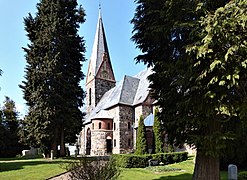
Christ Church, Hansühn

Döhnsdorf, Dorfstrasse in the center of the village
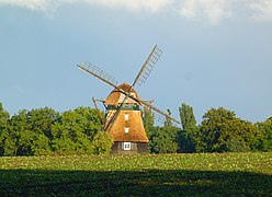
The Farver Mill from 1828
,_april_2019a_01.jpg)


goods
Ehlerstorf
The Ehlerstorf estate was founded in the late Middle Ages. The manor house is based on a typical semi-detached house , the core of which is from the 16th century. In the 20th century, the estate's courtyard was renovated in the historical style.
Farve
The Farve estate has existed since 1454, the current manor house was rebuilt in a neo-Gothic style in 1837. The estate is privately owned and is not accessible.
The Farver Mill - a windmill from 1828 - belongs to the estate .
Testorf
Gut Testorf was founded in 1460, today's neo-baroque mansion mostly dates from around 1774, was redesigned from 1764 to 1784 by the Eutin court architect Georg Greggenhofer and largely rebuilt again in 1902. The estate is privately owned and is not open to the public. The buildings are axially symmetrical and are located in a spacious park. The gatehouse built by Greggenhofer is particularly worth seeing.
Weissenhaus
The manor house of the Weißenhaus estate and the associated estate village with 16 houses (approx. 50 hectares ) were sold by Count Platen-Hallermund to the Hamburg entrepreneur Jan Henric Buettner in October 2005.
The manor house of Gut Friederikenhof, which once belonged to Weißenhaus, dates from 1895.
photos

Gut Testorf, old wheat barn


politics
Community representation
The 2018 election resulted in the following:
coat of arms
Blazon : “Quartered. 1 in red the silver Holstein nettle leaf, 2 in silver three blue wavy bars, 3 in silver a green fallow deer shovel, 4 in red a golden ear of wheat placed obliquely to the left. "
Personalities
- Ernst-Michael von Abercron (* 1952), politician
- Gerhard Eckert (1912–2009), writer, journalist and publicist, lives in Kükelühn
- Alice Ricciardi-von Platen , b. Countess von Platen-Hallermund (1910–2008), doctor and psychoanalyst
Web links
Individual evidence
- ↑ North Statistics Office - Population of the municipalities in Schleswig-Holstein 4th quarter 2019 (XLSX file) (update based on the 2011 census) ( help on this ).
- ↑ Schleswig-Holstein topography. Vol. 10: Timmaspe - Ziethen . 1st edition Flying-Kiwi-Verl. Junge, Flensburg 2008, ISBN 978-3-926055-92-7 , p. 149 ( dnb.de [accessed on August 9, 2020]).
- ↑ Schleswig-Holstein's municipal coat of arms
Ahrensbök | Old brim | Bad Schwartau | Beschendorf | Bosau | Dahme | Damlos | Eutin | Fehmarn | Göhl | Gremersdorf | Grömitz | Großenbrode | Pit | Harmsdorf | Heiligenhafen | Heringsdorf | Kabelhorst | Kasseedorf | Kellenhusen (Baltic Sea) | Lensahn | Malente | Manhagen | Neukirchen | Neustadt in Holstein | Oldenburg in Holstein | Ratekau | Riepsdorf | Scharbeutz | Schashagen | Schönwalde am Bungsberg | Sierksdorf | Stockelsdorf | Süsel | Timmendorfer Strand | Wangels