Pit (holstein)
| coat of arms | Germany map | |
|---|---|---|

|
Coordinates: 54 ° 14 ' N , 11 ° 2' E |
|
| Basic data | ||
| State : | Schleswig-Holstein | |
| Circle : | Ostholstein | |
| Management Community : | Groemitz | |
| Height : | 2 m above sea level NHN | |
| Area : | 20.2 km 2 | |
| Residents: | 1045 (Dec. 31, 2019) | |
| Population density : | 52 inhabitants per km 2 | |
| Postal code : | 23749 | |
| Area code : | 04364 | |
| License plate : | OH | |
| Community key : | 01 0 55 018 | |
| Address of the municipal administration: |
Kirchenstrasse 11 23743 Grömitz |
|
| Website : | ||
| Mayoress : | Kerstin Sköries ( CDU ) | |
| Location of the community of Grube in the Ostholstein district | ||
Grube is a municipality in the Ostholstein district in Schleswig-Holstein . The community of Grube includes the following villages and places to live: Gruberdieken, Gruber Fähre, Gruberfelde, Gruberhagen, Konzerberg, Muchelsdorf, Rosenfelde , Rosenhof, Schusterkrug, Siggeneben and Weberkamp.
geography
Grube is located in Wagrien about 18 km northeast of Neustadt , about 12 km (depending on the beeline ) southeast of Oldenburg and directly south of the eastern part of the Oldenburger Graben . The community is located near the Baltic Sea coast and has its own 2.5 km long natural beach on the Bay of Lübeck, Rosenfelder Strand . The natural area at the Oldenburger Graben between the Lübeck and Hohwacht bays is characterized by a zone with fens and wetlands.
politics
Community representation
After the 2018 elections, the eleven seats of the municipal council will be divided as follows:
- UGW : 4
- CDU : 7
administration
Grube belonged to the office of the same name from 1889 to 2006 . Since then, Grube and the municipalities of Dahme and Kellenhusen (Baltic Sea) have formed an administrative partnership with the municipality of Grömitz , which manages the administrative business for the three municipalities.
coat of arms
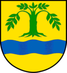
Blazon : "In gold over a blue wavy bar a rooted green deciduous tree."
The tree should represent a beech, from the Slavic term “coarse” (hornbeam or white beech) and the interpretation should also explain the current name “pit”. The location of the place in the former Gruber lake area is shown by the blue wave bar.
Culture
St. Jürgen Church
The more than 775 year old St. Jürgen Church has a carved altar from the 15th century.
Village museum
The village museum is located in a house that was built in 1890 and is typical of Grube. Since 1993 it has housed a folklore as well as prehistoric and early historical collection in the middle of the village, which was compiled by interested residents from Grube and the surrounding area.
Issued and documented are u. a. a fully furnished bedroom around 1900, a school classroom from the 1930s, fishing, thatch extraction and processing, the draining of the Gruber lake in 1938 as well as prehistoric and early historical finds. So shows z. B. a staging on a scale of 1:10 shows everyday life and handicrafts in the Stone Age. The institutions such as associations, village handicrafts, rural agriculture and the church that shaped the place are also documented. As a further attraction, the museum enables its visitors to take a look into the Gruber stork's nest via a still line.
The museum also shows a model of the former Gruber rectory; the original is in the Molfsee open-air museum . It was in this house that Johannes Stricker created his drama De düdesche Schlömer , published in 1584 .
graveyard
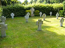
The cemetery is on the outskirts directly on the B 501 and is separated from it by tall green hedges.
In the cemetery there is a mass grave for 31 nameless concentration camp prisoners of the Cap Arcona disaster. A boulder with an inscription marks the grave field, which is to the right of the cemetery chapel.
A grave site with war graves from the Second World War is located to the left behind the cemetery chapel and is separated by a hedge.
archeology
The burial mound known as Eiskellerberg near Siggeneben .
Sports
The T. S. V. Grube e. V. offers handball, tennis and other sports.
The International Naturist Run takes place in Rosenfelde every year , organized by the DFK .
Economy and Infrastructure
traffic
Grube is about three kilometers inland from Dahme on the B 501 , which leads from Neustadt to Fehmarn .
Airfield
The Grube airfield , a sports airfield used by glider and motorized pilots as part of an association, is located in the municipality. Flight operations are therefore concentrated on the weekend. Every year in summer there is a two-week trial free time as part of youth work. As far as the weather permits, the flight operations take place all year round.
tourism
The 2.5 km long bathing beach with partly wide dunes is in front of the state protection dike Rosenfelde-Dahme. Immediately behind the dike there is a campsite and a nudist area on Rosenfelder Strand . In the southern part, naked stays are allowed in the 1.5 km long “nudist area”.
Sons and daughters of the church
- Johannes Stricker († 1599), Lutheran pastor and playwright
- Heinrich Adolf Burchardi (1788–1865), German Evangelical Lutheran clergyman and member of the Schleswig-Holstein state assembly
- Samuel Christoph Burchardi (1802–1882), German Evangelical Lutheran clergyman and member of the Schleswig-Holstein state assembly
Web links
Individual evidence
- ↑ North Statistics Office - Population of the municipalities in Schleswig-Holstein 4th quarter 2019 (XLSX file) (update based on the 2011 census) ( help on this ).
- ↑ Directory of the Ostholstein district about the villages and places to live ( MS Excel ; 175 kB)
- ↑ Schleswig-Holstein's municipal coat of arms
- ↑ Naturist Travel Guide Europe 2020, p. 36, A 03


