Oldenburger Graben
The Oldenburg trench is in the last glacial formed and at the height of the sea water level below sea level location groove in Ostholstein in Schleswig-Holstein .

location
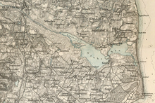
The Oldenburger Graben is located in Ostholstein on the Wagrien peninsula . It runs from Weißenhäuser Strand through Oldenburg in Holstein to Dahme and thus from the Hohwacht Bay to the outer Lübeck Bay . The nature reserve at the Oldenburger Graben is bounded in the west by the route of the Oldenburg – Neustadt railway line. In the north and north-east, the higher agricultural areas and the Gut Schwelbek farm are the border. In the southeast it is bounded by the western edge of the Schwienkuhler Bruch and in the south and southwest mainly by the municipality border between the city of Oldenburg and the municipality of Damlos .
length and width
The Oldenburger Graben is around 22 km long and between 2 and 20 meters wide. In Weißenhaus it is narrower than in Dahme. The trench is piped through the city of Oldenburg. Its total catchment area is approximately 22,000 hectares.
depth
The service water level in Weißenhaus is -1.60 m sea level (NN). In Dahme it is even lower at -1.90 m above sea level. The Köge are on average 3.5 m below sea level.
historical development
The landscape of the Oldenburg Graben was created in the Ice Age by glacial meltwater and a moraine landscape. More than 1000 years ago, the Oldenburger Graben served as part of the defense system of the city of Oldenburg and was loaded. Already between 1770 and 1815 there were various plans to drain the Gruber-See-Niederung, which is part of the area of the Oldenburger Graben. However, most failed for one reason, the sharing of costs among the participating communities. There were also plans to dike the area. Before 1836 a small lock was built in Rosenhofer Brök. In 1861 the Gruber See was drained and diked according to the "Irminger Plan". A few years later, the next dikes and a lock were built. After many years of disagreement and provisional solutions, it was finally believed that a permanent protection of the Gruber-See-Niederung had been created at high cost.
On November 13, 1872, there was a flood of the century that completely destroyed the dikes and damaged the lock. The protective dams flooded because the tide was four meters higher than previous tides. In 1874 new dikes were built at Weißenhaus and Dahme with a length of 8 km and a height of 4 meters above sea level with two large locks. The project was paid for by state subsidies, monetary donations and by the dike association of the Grube-Wessek-Niederung. Now the first drainage measures were taken because the farmers were interested in improving their lands.
In the Weimar Republic , agriculture was promoted in order to increase productivity, as around 4 million hectares of arable land had been lost through the cession of areas, which corresponded to a usable area of 14%. Many were against the construction work, which was subsidized with more than 50% by the state. Opponents of drainage said the measures would be a depletion of the state treasury and would lead to considerable subsidence and destroy the existence of five professional fishermen. However, the critics could not prevail and it was unanimously agreed on the usefulness of the project.
The farmers played a very important role in the National Socialist agricultural policy . Germany should become self-sufficient and thus economically and thus politically no longer open to blackmail. During war, people wanted to be able to feed themselves. That is why from 1933 there were many measures to improve the situation of the farmers. The drainage and thus the creation of the Köge was made possible by the Reich Labor Service (RAD) as part of Hitler's job creation measures . All men and women between 18 and 25 had six months of compulsory labor service. The drainage should take 7 to 8 years. A peripheral canal was leveled and built, the small and large heather were converted and the large moor near Riepsdorf / Quaal was leveled and fertilized. The Koselau was relocated and its tributaries regulated. In 1941 the Gaarzer and Rosenhofer lakes were drained. 5 years later the Koogdeiche was flooded and the Gruber-See-Koog was full.
Between 1958 and 1972 the total dyke association was rebuilt. In the course of this, the Baltic Sea dikes were raised. The lock in Weißenhaus was expanded and the pumping station overhauled. In Dahme, the lock and the pumping station were rebuilt. The canal embankments were raised and the Gaarzer Graben relocated. Two new kays were created, the Seewiesen Koog and the Dannauer Koog. The Koogdeiche were reinforced. All of these measures were funded by the state. In 1998, 358 hectares of the Oldenburg quarry were placed under nature protection.
The Stone Age perforated rod from Grube-Rosenhof was found here in 2002.
drainage
Advantages and disadvantages
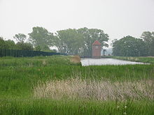
Large parts of the Oldenburger Graben were drained and drained in order to use them economically. Now ditch systems, pumps and locks keep the privately owned keds dry. The water is fed into the Oldenburger Graben. The difficulty is that the Oldenburger Graben is 1.6–1.9 m below sea level and the Köge at –3.5 m above sea level. Therefore the water has to be pumped up.
There are some conflicting interests. The farmers are in favor of constant drainage , for soil improvement and thus the expansion of the usable area. The state also sees its advantages in this drainage. There is also a public interest in a functioning drainage. State nature conservation and the increasing importance of nature conservation in public opinion speak against this drainage. In the past, there was also the drive to be self-sufficient. One point of criticism, however, was the fishing interests. Despite the disadvantages, the areas were drained, but compromises are necessary for a functioning system.
But the drainage had some negative effects. There was severe subsidence and many animals and plant species lost their natural habitat. In addition, the drainage is financially very troublesome because the kegs have to be constantly drained. However, if too much water is drained, the moor dries up and cracks open. The moor sags unevenly, which makes it considerably more difficult to use because the moor hardly absorbs any water. Therefore, the area needs to be plowed every 5–8 years.
However, there are also many positive consequences. New arable land was gained, especially in Matzenkoog and Gruber Seekoog. There is lush fodder grass there all summer, while the grass on the higher mineral soils withers slightly in dry seasons (June / July). In the spring the grass turns green faster because the drained bog warms up faster.
The edge channel
Rainwater that comes from the Bungsberg and the other higher areas does not run into the Oldenburger Graben, but into the Randkanal. The Johannisbek was converted into a peripheral canal for this purpose. The edge channel serves the purpose of preventing and preventing the Oldenburg Graben from overflowing. Some of the water that seeps into the ground reaches the Oldenburger Graben underground. Because of this, the moat rises over time. Parts of the Wesseker See used to be drained. But in order to save costs, it was rewetted. If too much water or rain runs into the lake, it will expand. It can take up to seven days for the lake to return to its normal size.
Köge
The drainage resulted in the following kegs:
- the Dannau-Wessek-Koog
- the Feddersen-Koog
- the Seewiesen-Koog
- the Gaarzer Koog
- the Matzen-Koog
- the Gruber-See-Koog
These kogs are constantly drained.
Nature and conservation
In the area of the trench there are four nature reserves : the nature reserve “ Oldenburger Bruch ” southeast of Oldenburg, the small nature reserve “ Lübbersdorfer Kiesgrube ”, the nature reserve “ Wesseker See ” west of Oldenburg and the nature reserve “ Weißenhäuser Brök ” directly on the coast. Further sub-areas are recorded as European bird protection areas ("Oldenburger Graben" with the area number 1731-401 and "Eastern Bay of Kiel" with the number 1530-491).
In 1998, 358 hectares of the Oldenburger Bruch were placed under nature protection. The protection purpose is to permanently preserve nature in this area in its entirety. The drainage intervened sharply in nature. The peat and reforestation led to further interventions. This changed the habitat of many animal and plant species. Many disappeared and new ones settled. In the nature reserve, the former wet meadows are to be restored and preserved in order to create a habitat for typical plant and animal species. To do this, the groundwater is dammed up in order to rewet parts of it.
The Wesseker See is regarded as a body of water with national importance for water birds and as a sleeping place for spoonbills and gadgets with international importance. The lowland area with its floodplain is a retreat for breeding birds as well as for resting and foraging birds during migration and in winter.
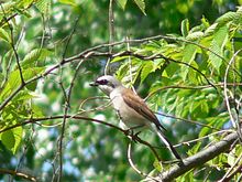
In the reed beds breed reed warbler , reed bunting and occasionally Marsh Harriers , Red-backed Shrike , Nightingale , Whinchat and bag chickadees . In total there are over 120 species of birds and well over 500 species of plants. 55 species are on Schleswig-Holstein's Red List , such as the Karthauser carnation , Heil-Ziest and Großer Klappertopf . 2008 was in the pit , the extinct since 1978 in Schleswig-Holstein at the Oldenburger Graben little bittern identified as a breeding bird.
The head trees typical of the Oldenburger Bruch also provide habitats for little owls and martens . The Matzenkoog in the Oldenburger Graben is part of the Natura 2000 area "Oldenburger Graben". An area for water birds is to be created there in order to achieve even greater biodiversity in the Oldenburger Graben. There are still some nature conservation projects planned, for example the renaturation of the Johannisbek (4.5 km) and the processing of its strips of arable land.
Advancement
The political goals in the area of the Oldenburger Graben are mainly to rewet nature in order to create more habitat for animals. Selected areas are bought up and partially rewetted. It is not possible to water everything, because then the landowners would lose their land because it would flood. The goal is to enlarge the existing nature reserve.
The area of the Oldenburg Graben also plays a role in the planned Fehmarnbelt crossing , in which Germany is to be connected to Denmark via the island of Fehmarn by means of a bridge. So far, no political decision has been made about the construction of the fixed link or the associated expansion measures for the hinterland connections, but it cannot be avoided that this area has to be crossed with new traffic routes. All variants cause considerable and lasting effects and would also cut off parts of the “Oldenburger Bruch” nature reserve located there. For this reason, it was expressly recommended that any route crossing the Oldenburger Graben that could be avoided should be avoided.
literature
- Yearbook for local history. Oldenburg / Holstein, 32nd year, 1988
Individual evidence
- ↑ http://meeresbrise.de/ostsee/wp-content/uploads/2008/08/ Zwischenbreicht-adebar- 2008.pdf , accessed on September 28, 2009


