Fehmarn Sound
| Fehmarn Sound | ||
|---|---|---|
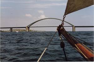
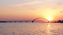
| Fehmarnsund Bridge from the Sund | ||
| Connects waters | Kiel Bay | |
| with water | Mecklenburg Bay | |
| Separates land mass | Fehmarn | |
| of land mass | Wagrien ( Holstein ) | |
| Data | ||
| Geographical location | 54 ° 23 '59 " N , 11 ° 7' 1" E | |
|
|
||
| length | 8 kilometers | |
| Smallest width | 800 m | |
| Coastal towns | Heiligenhafen , Fehmarn , Großenbrode | |
| bridges | Fehmarnsund Bridge | |
The Fehmarnsund is the estuary of the Baltic Sea between Kiel Bay and Mecklenburg Bay , which separates the island of Fehmarn from the mainland . By 1963, he was supported by a train ferry with car transport between Großenbrode ferry crossing and the place Fehmarnsund until in the course of completion of Vogelfluglinie the Fehmarn bridge was built. Localities on Fehmarnsund are, depending on the perspective, Heiligenhafen and Großenbrode on the mainland and on the island west of the bridge Orth , Lemkenhafen , Westerberg Ort, Albertsdorf and Strukkamp and further east the towns of Fehmarnsund with the former ferry port, Avendorf , Wulfen , Burg and Staberdorf , for which reason is that since January 1, 2003, all municipalities on the island of Fehmarn have been combined into a newly formed city of Fehmarn administratively and postally as a city .
Data
Fehmarnsund is about eight kilometers long and at the narrowest point about 800 meters wide, with the depth of the sound between 3 and 11 meters. The sea floor consists of solid to hard rock and is mostly covered with muddy matter and loose rock. The water temperature fluctuates between 2 and 19 ° C due to the seasons ; in more extreme weather conditions these values can also be exceeded or undercut. In the winter of 1978/1979 and in the later course of the winter of 2006 there were more serious undershoots, with ice formation first starting near the shore. The Baltic Sea water of Fehmarnsund has an average salinity of no more than 1.8%. The salinity depends on the flow of the water , which mainly flows through from the west, but can also reach the sound in the opposite direction depending on the east wind or storm. The further west of Fehmarn the salinity is measured, the higher the value, the further east, the lower. In addition, the deeper the measurement, the higher the salt content, which is related to the fact that fresh water is lighter than salt water. The salt water of the Fehmarn Sound would have a higher density and heat capacity than fresh water with increasing salinity from the western inflow, which can mean decreasing buoyancy in the shallow water near the island of Fehmarn with decreasing salinity.
fishing
Professional and sport fishing is practiced on Fehmarnsund . The professional fishing is also exerted with pots and gill nets for cod, herring and flatfish, eel sometimes limited by varying over the years fixed catch quotas. The practice of fishing requires a valid life fishing license in one's own name and the proof sheet Fischereiabgabe Schleswig-Holstein (10 euros) or the holiday fishing license as a temporary special permit ; it must be possible to show these documents on site. Deviations are possible locally.
tourism
For tourism, there is a wide range of excursion destinations and attractions near Fehmarnsund, such as B. 5 lighthouses, the museums and island churches, natural beaches and the Fehmarnsund Bridge, which has been a listed building since 1999. There is a wide range of hotels and restaurants , including accommodation for allergy sufferers due to the island's climate, and three campsites on the island side directly on the Sund at a distance of 1.5 or 4 kilometers from the Fehmarnsund Bridge. The island offers a signposted network of cycle paths with a length of around 300 kilometers, which also offers a wide range of tourist two-wheeler excursions.
Sports
Fehmarnsund is a popular sailing and surfing area, as there are regularly good westerly winds. In terms of infrastructure, there are yacht harbors near the Sund in the towns of Fehmarnsund, Lemkenhafen, Orth and Großenbrode. The sports offer also includes sailing and windsurfing schools . In the east of Fehmarnsund there is an island golf course with 18-hole course ( par 72) and a public 9-hole course (par 54) at Wulfener Hals .
Transport connections across the Fehmarnsund
Motorized ferry traffic 1903–1963
Already in the beginning of the 13th century there was a ferry connection over the Fehmarn Sound, which connected the island of Fehmarn with the mainland.
The ferry Fehmarnsund was the first motorized Sundfähre. As the only double-ended ferry in Fehmarnsund, it was in service from September 1903 to 1949, of which only until 1927. It was equipped with a railroad track on which two freight cars could be transported. Their steam engine drive developed 130 hp. The Fehmarnsund tore itself from its berth in an autumn storm in 1921 during high tide and ran aground. It took months before it could be towed free again in another flood.
From 9 November 1927, the steam ferry added Fehmarn the Fehmarn. It had 2 × 240 hp and could also transport passenger coaches (rail buses) with a track length of 37 m. In 1951 it was lengthened by 15 m and received a diesel drive.
In 1949, after 46 years , the motor ship Schleswig-Holstein replaced the steamship Fehmarnsund. It had a track length of 41 m and could accommodate up to four railway cars. At the same time, the motor ship Reichsbahn also operated, but was only used for passenger transport when there was an increased number of passengers or in emergencies.
After the Fehmarnsund Bridge was opened in May 1963, ferry traffic was stopped. The Schleswig-Holstein ferry was sold to Italy a few years later, where it was renamed Ferry Capri . The Fehmarn also went to Italy and was used as Peloritano in the Strait of Messina . It last operated in the Gulf of Naples until it was scrapped in 2010. However, the aforementioned Schleswig-Holstein ferry is not the Schleswig-Holstein ferry operated by Wyker Dampfschiffs-Reederei (WDR) or Scandlines Deutschland GmbH. The WDR ferry is of a newer design (2011) and runs between Dagebüll and Föhr and Amrum. The Scandlines - the same name ferry is a combined vehicle and rail ferry, she served since 1997 Vogelfluglinie between the ferry ports of Puttgarden and Rødbyhavn .
Sound Bridge
The Fehmarnsund has been crossed by the Fehmarnsund Bridge since 1963 . As a road and railway bridge, the bridge connects the Baltic Sea island of Fehmarn with the mainland at Großenbrode; it is to be replaced by a new one in connection with the construction of the Fehmarnbelt Fixed Link.
Tunnel (planned)
On March 3, 2020, plans were announced according to which the Fehmarnsund Bridge should be supplemented by an immersed tunnel by 2028. The Fehmarnsund tunnel is to be around 1.7 km long and will be designed as a combined motorway and rail tunnel. The bridge will remain in place and will be available to pedestrians, cyclists and slow traffic in the future.
Web links
Individual evidence
- ↑ K. Wegner, et al .: Ferries of the Baltic Sea . Transpress Verlag, Berlin 1991, ISBN 3-344-70719-1 .
- ↑ Things seen - May 2011. Posts tagged: peloritano. hhvferry.com/blog, May 20, 2011, accessed May 15, 2018 (American English).
- ^ Decision on the new Fehmarnsund link, press release Deutsche Bahn AG, March 3, 2020


