Molesbach
| Molesbach | ||
|
|
||
| Data | ||
| Water code | DE : 267312 | |
| location | Rhineland-Palatinate , Germany | |
| River system | Rhine | |
| Drain over | Moselle → Rhine → North Sea | |
| source | East of Fell 49 ° 46 ′ 41 ″ N , 6 ° 48 ′ 38 ″ E |
|
| Source height | approx. 401 m above sea level NN | |
| muzzle | South of Mehring in the Moselle Coordinates: 49 ° 47'29 " N , 6 ° 49'5" E 49 ° 47'29 " N , 6 ° 49'5" E |
|
| Mouth height | approx. 120 m above sea level NN | |
| Height difference | approx. 281 m | |
| Bottom slope | approx. 15% | |
| length | 1.9 km | |
| Catchment area | 4.984 km² | |
The Molesbach is a right tributary of the Moselle in Rhineland-Palatinate , Germany .
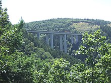
It has a length of 1.9 km, a catchment area of 5 km² and flows between Riol and Mehring . The Molesbachtalbrücke of the federal motorway 1 , which leads from Schweich towards Hermeskeil , runs over the Molesbach .
Individual evidence
- ↑ a b Topographic map 1: 25,000
- ↑ a b Rhineland-Palatinate Water Management Authority
