Kleinwörden
|
Kleinwörden
Lüttwöhrn ( Low German ) Municipality Hechthausen
|
|
|---|---|
| Coordinates: 53 ° 39 ′ 30 ″ N , 9 ° 14 ′ 52 ″ E | |
| Height : | 0 m above sea level NHN |
| Area : | 6.72 km² |
| Residents : | 389 (Sep 13, 1950) |
| Population density : | 58 inhabitants / km² |
| Incorporation : | July 1, 1972 |
| Postal code : | 21755 |
| Area code : | 04774 |
|
Location of Kleinwörden in Hechthausen
|
|
Kleinwörden ( Low German Lüttwöhrn ) is a district of the municipality Hechthausen in the integrated municipality of Hemmoor in the Lower Saxony district of Cuxhaven .
history
Incorporations
On July 1, 1972, Kleinwörden was incorporated into the municipality of Hechthausen.
Population development
| year | Residents | source |
|---|---|---|
| 1824 | - ¹ | |
| 1848 | 385 square meters | |
| 1910 | 319 | |
| 1925 | 261 | |
| 1933 | 233 | |
| 1939 | 217 | |
| 1950 | 389 |
¹ 56 fireplaces
² in 69 houses
politics
City council and mayor
The town of Kleinwörden is represented by the council of the municipality of Hechthausen.
coat of arms
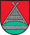
| Blazon : "In red on a green hill coveredwith silver wavy stripes ,a silver house gable from Lower Saxony." | |
| Justification for the coat of arms: The gable symbolizes the old settlement, the wavy strip the location on the Oste river, the hill in the shield base the Wurt and thus the place name “Wörden”. |
Culture and sights
Architectural monuments
→ See: List of architectural monuments in Kleinwörden
Personalities
Sons and daughters of the place
- Ute Wedemeier , b. Flämig (* 1948), social politician ( SPD )
literature
- 650 years of Kleinwörden. 1346-1996 . 1997.
Web links
Commons : Kleinwörden - Collection of images
Individual evidence
- ↑ a b c Federal Statistical Office (Hrsg.): Official municipality register for the Federal Republic of Germany . Final results according to the September 13, 1950 census. Volume 33 . W. Kohlhammer Verlag, Stuttgart / Cologne August 1952, p. 49 , col. 1 ( digital version [PDF; 26.4 MB ; accessed on October 22, 2019] Landkreis Land Hadeln, p. 58).
- ^ Federal Statistical Office (ed.): Historical municipality directory for the Federal Republic of Germany. Name, border and key number changes in municipalities, counties and administrative districts from May 27, 1970 to December 31, 1982 . W. Kohlhammer, Stuttgart / Mainz 1983, ISBN 3-17-003263-1 , p. 243 .
- ^ Friedrich Jansen: Statistical Manual of the Kingdom of Hanover (= Statistical Manuals for the Kingdom of Hanover ). Helwing'sche Hofbuchhandlung, Celle 1824, p. 678 ( digitized version in Google Book Search [accessed October 22, 2019]).
- ↑ Friedrich W. Harseim, C. Schlüter: Statistical Handbook for the Kingdom of Hanover (= Statistical Handbooks for the Kingdom of Hanover ). Schlüter'sche Hofbuchdruckerei, Hanover 1848, p. 150 ( digitized version in Google Book Search [accessed October 22, 2019]).
- ^ Ulrich Schubert: Community directory Germany 1900 - Neuhaus an der Oste district. Information from December 1, 1910. In: gemeindeververzeichnis.de. February 3, 2019, accessed October 22, 2019 .
- ↑ a b c Michael Rademacher: German administrative history from the unification of the empire in 1871 to the reunification in 1990. Landkreis Land Hadeln ( see under: No. 27 ). (Online material for the dissertation, Osnabrück 2006).
- ^ Rudolf Lembcke: Land Hadeln district. Past and present . Ed .: District of Hadeln. Buchdruckerei Günter Hottendorff, Otterndorf 1976, p. 39 (coat of arms).


