
Singing
| coat of arms | Germany map | |
|---|---|---|

|
Coordinates: 53 ° 22 ' N , 9 ° 13' E |
|
| Basic data | ||
| State : | Lower Saxony | |
| County : | Rotenburg (Wümme) | |
| Joint municipality : | Singing | |
| Height : | 27 m above sea level NHN | |
| Area : | 41.86 km 2 | |
| Residents: | 3601 (Dec. 31, 2019) | |
| Population density : | 86 inhabitants per km 2 | |
| Postal code : | 27446 | |
| Area code : | 04284 | |
| License plate : | ROW, BRV | |
| Community key : | 03 3 57 043 | |
| LOCODE : | DE 75Z | |
| Community structure: | 6 districts | |
| Mayor : | Reinhard Aufdemkamp ( CDU ) | |
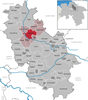
| Location of the municipality of Selsingen in the Rotenburg (Wümme) district | ||
  |
||


Selsingen ( Low German : Sürsen ) is a municipality and the administrative seat of the Selsingen joint municipality of the same name in the Rotenburg (Wümme) district in Lower Saxony .
geography
Geographical location
Selsingen is located in the Zevener Geest and on the Oste .
Community structure
Today's community consists of the core town of Selsingen and the districts of Eitzte , Granstedt , Haaßel , Lavenstedt and Parnewinkel .
Neighboring communities
The municipality of Selsingen borders in the northeast on the municipality Deinstedt , in the east on the municipality Anderlingen , in the southeast on the municipality Seedorf , in the southwest on the municipality Ostereistedt , in the west on the municipality Gnarrenburg and in the northwest on the municipality Sandbostel . With the exception of Gnarrenburg, all neighboring communities belong to the Selsingen joint community.
history
Although the name of the core town was first mentioned in a document in 1219, the settlement is likely to be much older. A noble family resided here, who no longer called themselves "von Selsingen" after the destruction of the castle, but only called themselves "von der Kuhla " after the seat of their second house . The place Lavenstedt, which can be found in documents from the years 971 and 986, is likely to be particularly old.
In the Middle Ages and in the early modern period, Selsingen was the main town in the administrative and judicial district of the Börde Selsingen. These included the villages Altenburg, Anderlingen , Baaste , Bademühlen , Badenstedt , Bockel, Bockhorst , Brauel , Byhusen , Deinstedt , Eitzte , Falje, Farven , Godenstedt , Gosehus, Grafel , Granstedt , Haaßel , cottages, small Bostel, Lavenstedt , Malstedt , Minstedt , Mintenburg , Mojenhop, Ober Ochtenhausen , Ölkershusen, Ohrel , Ostereistedt , Parnewinkel , Plönjeshausen , Rockstedt , Rohr, Rugenberg, Sandbostel , Sassenholz , Schohöfen, Seedorf , Selsingen , Stoppelheide, Twistenbostel, Wennebostel, Windershusen and Winderswohlde .
The villages of Selsingen, Granstedt, Haaßel and Ober Ochtenhausen have successfully participated in the national competitions " Our village should be more beautiful ".
On April 15, 1986, an F-16 of the Dutch Air Force crashed near Parnewinkel. The pilot was killed in the crash.
Incorporations
On March 1, 1974, the communities Granstedt, Haaßel, Lavenstedt and Parnewinkel were incorporated.
religion
In Selsingen there is the Evangelical Lutheran parish of St. Lamberti.
politics
Municipal council
The council of the municipality of Selsingen consists of 15 councilors and councilors. This is the specified number for the member municipality of an integrated municipality with a population between 3001 and 5000 inhabitants. The council members are elected for a five-year term by local elections. The current term of office began on November 1, 2016 and ends on October 31, 2021.
The last local election on September 11, 2016 resulted in the following:
| Political party | Proportional votes | Number of seats |
|---|---|---|
| CDU | 59.69% | 9 |
| SPD | 24.34% | 4th |
| WFB community Selsingen | 15.95% | 2 |
The turnout in the 2016 local elections was 63.47%, above the Lower Saxony average of 55.5%.
mayor
The council elected the council member Reinhard Aufdemkamp (CDU) as honorary mayor for the current electoral term.
coat of arms
Description: In silver, a straight red tip with a crossed gold bailiff and a combat sword .
Community partnerships
The community has been in partnership with the English city of Sawston since 1990 .
Economy and Infrastructure
traffic
The municipality is located on the federal road 71 between Bremervörde and Zeven and on the Bremervörde − Zeven − Rotenburg railway line . However, the railway line is only used by freight trains. Public transport is carried out by regular buses .
Industry
A medium-sized manufacturer of cemetery excavators and municipal vehicles is based in Selsingen.
Personalities
- Walter Hinck (1922–2015), Germanist
literature
- Michael Ehrhardt: The Börde Selsingen - rule and life in a rural district on the Stader Geest in the Middle Ages and in the early modern period. Landschaftsverband Stade, Stade 1999, ISBN 3-931879-04-6 .
Web links
Individual evidence
- ↑ State Office for Statistics Lower Saxony, LSN-Online regional database, Table 12411: Update of the population, as of December 31, 2019 ( help ).
- ↑ Michael Ehrhardt: The Börde Selsingen - rule and life in a rural district on the Stader Geest in the Middle Ages and in the early modern period. Stade 1999.
- ↑ 1986: F 16 crashes into the field. ( Memento from December 21, 2013 in the web archive archive.today ) at: brv-zeitung.de , April 14, 2011.
- ^ Federal Statistical Office (ed.): Historical municipality directory for the Federal Republic of Germany. Name, border and key number changes in municipalities, counties and administrative districts from May 27, 1970 to December 31, 1982 . W. Kohlhammer, Stuttgart / Mainz 1983, ISBN 3-17-003263-1 , p. 242 .
- ^ Lower Saxony Municipal Constitutional Law (NKomVG) in the version of December 17, 2010; Section 46 - Number of MPs , accessed on March 18, 2017.
- ↑ a b Municipality of Selsingen - overall results of municipal council elections 2016 ( memento of the original from March 19, 2017 in the Internet Archive ) Info: The archive link was inserted automatically and has not yet been checked. Please check the original and archive link according to the instructions and then remove this notice. , accessed March 18, 2017.
- ↑ The CDU gets the most votes nationwide. September 12, 2016. Retrieved March 18, 2017 .
- ↑ Municipality of Selsingen - Council of the Municipality of Selsingen 2016–2021 , accessed on March 18, 2017.
Ahausen | Alfstedt | Otherlings | Basdahl | Botersen | Bothel | Breddorf | Bremervörde | Brockel | Bülstedt | Deinstedt | Ebersdorf | Elsdorf | Farven | Fintel | Gnarrenburg | Groß Meckelsen | Gyhum | Hamersen | Hassendorf | Heeslingen | Hellwege | Helvesiek | Hemsbünde | Hemslingen | Hepstedt | Hipstedt | Horstedt | Calf | Kirchtimke | Kirchwalsede | Klein Meckelsen | Lauenbrück | Lengenbostel | Oerel | Ostereistedt | Reeßum | Rhade | Rotenburg (Wümme) | Sandbostel | Scheeßel | Seedorf | Singing | Sittensen | Sottrum | Chisel | Tarmstedt | Tiste | Vahlde | Vierden | Visselhövede | Vorwerk | Westertimke | Westerwalsede | Wilstedt | Residential | Zeven