
Hemslingen
| coat of arms | Germany map | |
|---|---|---|

|
Coordinates: 53 ° 5 ' N , 9 ° 36' E |
|
| Basic data | ||
| State : | Lower Saxony | |
| County : | Rotenburg (Wümme) | |
| Joint municipality : | Bothel | |
| Height : | 39 m above sea level NHN | |
| Area : | 27.47 km 2 | |
| Residents: | 1429 (Dec. 31, 2019) | |
| Population density : | 52 inhabitants per km 2 | |
| Postal code : | 27386 | |
| Area code : | 04266 | |
| License plate : | ROW, BRV | |
| Community key : | 03 3 57 025 | |
| LOCODE : | DE 75X | |
| Community structure: | 2 districts | |
| Association administration address: | Horstweg 17 27386 Bothel |
|
| Website : | ||
| Mayor : | Henry Gerken ( SPD ) | |
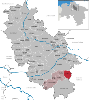
| Location of the municipality of Hemslingen in the Rotenburg (Wümme) district | ||
  |
||


Hemslingen is a municipality in the Rotenburg (Wümme) district in Lower Saxony . Hemslingen is part of the joint municipality of Bothel - with 27.47 km² the second largest municipality within the joint municipality.
geography
location
Hemslingen is located about 14 km southeast of Rotenburg (Wümme) , 8 km northwest of Neuenkirchen , 6 km east of Bothel and 10 km west of Schneverdingen . The Bruchwiesenbach runs between the two districts. The highest point is the Hollerberg at 52.8 m above sea level. NHN .
Community structure (districts)
- Hemslingen (main town)
- Söhlingen
Neighboring communities
| Scheeßel | ||
| Brockel |
.svg)
|
Neuenkirchen ( district of Heidekreis ) |
| Visselhövede |
geology
Natural gas is one of the mineral resources. One of the largest natural gas reserves in Germany is located in the area around Hemslingen.
history
Origin of the place name
Old names of the place are around 1320 Hemslinge, 1540 Heymsling and 1692 Hembsel.
The place name is derived from the male personal name short forms "Hemmi" or "Hemiso". For example: "The settlement of the people of Hemmi or Hemiso". The personal name is derived from the old stem "Ham". The name goes back to the Gothic "hamôn", which means "to cover, to clothe". In Old Norse it stands for "shell, skin, outer shape".
Incorporations
As part of the regional reform in Lower Saxony , the previously independent neighboring municipality of Söhlingen was incorporated into the municipality of Hemslingen on March 1, 1974.
Population development
|
|
¹ as of December 31st

|
politics
Municipal council
The council of the municipality of Hemslingen consists of ten councilors. This is the specified number for the member municipality of an integrated municipality with a population between 1001 and 2000 inhabitants. The council members are elected for a five-year term by local elections. The current term of office began on November 1, 2016 and ends on October 31, 2021.
The honorary mayor is also entitled to vote and sit on the municipal council.
The last local election on September 11, 2016 resulted in the following:
| Political party | Proportional votes | Number of seats |
|---|---|---|
| CDU | 43.49% | 5 |
| SPD | 41.79% | 4th |
| GREEN | 14.70% | 2 |
The turnout in the 2016 local elections was 66.58%, above the Lower Saxony average of 55.5%.
mayor
The local council elected councilor Henry Gerken (SPD) as honorary mayor for the current electoral term.
coat of arms
|
|
Blasonierung : "From a silver obliquely right wave beams split escutcheon , left a green field with a black - white thatched double column truss Hallenhaus with hip roof and large hall door , right red field with a black-and-white Four stand-truss Hallenhaus with partial hip and a vertically superposed hatch series . " |
Reasons for the coat of arms: The municipality of Bothel writes about this on their website:
|
Economy and Infrastructure
Companies
One of the largest natural gas reservoirs in Germany with numerous drilling sites is located in the municipality. The reservoir water containing BTEX is injected at a depth of approx. 1000 m. Söhlingen is the location of a steel construction company.
Health and social
The closest general practice practices are in Bothel, Brockel and Neuenkirchen . Hemslingen is the only municipality in the joint municipality of Bothel to be part of the Soltau medical on- call district . An accumulation of cancer cases, especially among men, gave rise to a special evaluation of the Lower Saxony epidemiological cancer register in 2014 for the municipality of Bothel.
Personalities
- Fritz G. Rathjen (* 1952), Professor of Developmental Neurobiology at the Max Delbrück Center for Molecular Medicine in the Helmholtz Association
Web links
Individual evidence
- ↑ State Office for Statistics Lower Saxony, LSN-Online regional database, Table 12411: Update of the population, as of December 31, 2019 ( help ).
- ^ Jürgen Udolph (research): The "place name researcher". In: Website NDR 1 Lower Saxony . Archived from the original on November 27, 2015 ; accessed on August 4, 2019 .
- ^ Federal Statistical Office (ed.): Historical municipality directory for the Federal Republic of Germany. Name, border and key number changes in municipalities, counties and administrative districts from May 27, 1970 to December 31, 1982 . W. Kohlhammer, Stuttgart / Mainz 1983, ISBN 3-17-003263-1 , p. 245 .
- ^ Ulrich Schubert: Community directory Germany 1900 - District of Rotenburg in Hanover. Information from December 1, 1910. In: gemeindeververzeichnis.de. January 5, 2020, accessed June 7, 2020 .
- ^ A b c Michael Rademacher: German administrative history from the unification of the empire in 1871 to the reunification in 1990. District of Rotenburg ( see under: No. 22 ). (Online material for the dissertation, Osnabrück 2006).
- ↑ a b Statistisches Bundesamt Wiesbaden (ed.): Official municipality register for the Federal Republic of Germany - 1957 edition (population and territorial status September 25, 1956, for Saarland December 31, 1956) . W. Kohlhammer, Stuttgart 1958, p. 189 ( digitized version ).
- ↑ Lower Saxony State Administration Office (ed.): Municipal directory for Lower Saxony . Municipalities and municipality-free areas. Self-published, Hanover January 1, 1973, p. 45 , Wesermünde district ( digitized version ( memento from August 7, 2019 in the Internet Archive ) [PDF; 21.3 MB ; accessed on June 7, 2020]).
- ↑ a b c d e f g h i j community directory - archive - regional structure - annual editions - Lower Saxony. (All politically independent municipalities in EXCEL format). In: Destatis website. Federal Statistical Office, accessed on June 7, 2020 .
- ↑ a b c d e Hemslingen local council. In: Website Samtgemeinde Bothel. Retrieved June 7, 2020 .
- ^ Lower Saxony Municipal Constitutional Law (NKomVG); Section 46 - Number of Deputies. In: Lower Saxony Regulations Information System (NI-VORIS). December 17, 2010, accessed June 7, 2020 .
- ↑ a b Municipality of Hemslingen - overall results of the 2016 municipal council election. In: Website Zweckverband Kommunale Datenverarbeitung Oldenburg (KDO). September 11, 2016, accessed June 7, 2020 .
- ↑ The CDU gets the most votes nationwide. In: Website Norddeutscher Rundfunk . September 12, 2016, accessed June 7, 2020 .
- ↑ Evaluation of the EKN on the frequency of new cancer cases in the joint community of Bothel. (PDF; 306 kB) In: Website Epidemiological Cancer Register Lower Saxony - Oldenburg. September 2014, accessed June 7, 2020 .
- ^ AG Rathjen Developmental Neurobiology. In: Website Max Delbrück Center. Retrieved June 7, 2020 .
Ahausen | Alfstedt | Otherlings | Basdahl | Botersen | Bothel | Breddorf | Bremervörde | Brockel | Bülstedt | Deinstedt | Ebersdorf | Elsdorf | Farven | Fintel | Gnarrenburg | Groß Meckelsen | Gyhum | Hamersen | Hassendorf | Heeslingen | Hellwege | Helvesiek | Hemsbünde | Hemslingen | Hepstedt | Hipstedt | Horstedt | Calf | Kirchtimke | Kirchwalsede | Klein Meckelsen | Lauenbrück | Lengenbostel | Oerel | Ostereistedt | Reeßum | Rhade | Rotenburg (Wümme) | Sandbostel | Scheeßel | Seedorf | Singing | Sittensen | Sottrum | Chisel | Tarmstedt | Tiste | Vahlde | Vierden | Visselhövede | Vorwerk | Westertimke | Westerwalsede | Wilstedt | Residential | Zeven