
Kirchtimke
| coat of arms | Germany map | |
|---|---|---|

|
Coordinates: 53 ° 15 ' N , 9 ° 9' E |
|
| Basic data | ||
| State : | Lower Saxony | |
| County : | Rotenburg (Wümme) | |
| Joint municipality : | Tarmstedt | |
| Height : | 24 m above sea level NHN | |
| Area : | 16.15 km 2 | |
| Residents: | 919 (Dec. 31, 2019) | |
| Population density : | 57 inhabitants per km 2 | |
| Postal code : | 27412 | |
| Area code : | 04289 | |
| License plate : | ROW, BRV | |
| Community key : | 03 3 57 030 | |
| Community structure: | 2 districts | |
| Association administration address: | Hepstedter Strasse 9 27412 Tarmstedt |
|
| Website : | ||
| Mayor : | Frank Tibke | |
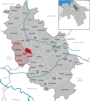
| Location of the community Kirchtimke in the district of Rotenburg (Wümme) | ||
  |
||

Kirchtimke is a municipality in the Tarmstedt municipality in the Rotenburg (Wümme) district in northwestern Lower Saxony .
geography
location
Kirchtimke is located in the natural area of Stader Geest . The forest area "Schierk" is located southeast of Kirchtimke. The “ Bullensee ” nature reserve is located a little southeast of Ostertimke . The community is predominantly characterized by agricultural land .
Community structure
In addition to the village of Kirchtimke, the district of Ostertimke also belongs to the community.
history
The place was first mentioned in 1148. The village used to be called "Tymbeke".
A first church was probably built in the 12th century, as indicated by the Romanesque baptismal font (around 1200) and the valuable carved early Gothic crucifix (around 1280). During the church renovation in 1962, relics were found in the old crucifix , wrapped in cloth and inscribed with the names of Saints Lambertus and Pankratius, as well as sand from the Holy Land. Since then the ev.-luth. Church the nickname of Lambert. St. Lambertus Church was rebuilt in 1739 after the old church had become too small for the larger parish. In 1884 the church tower was rebuilt and the old round stone tower demolished.
Place name
Timke is an old water body name, it contains "-beke" ("Bach"), today Westertimker Beek. Timke should come from "Tin-" or "Tim-". Since it is followed by a “-b-”, it is more likely that an older “Tin-beke” can be assumed. The basis is likely to be a Germanic clan. "Tine, tina" means "melt, mud". The place name most likely means "soil dissolved by water, damp, flooded land".
Incorporations
As part of the regional reform in Lower Saxony , the previously independent neighboring municipality of Ostertimke was incorporated into the municipality of Kirchtimke on March 1, 1974.
politics
Municipal council
The council of the municipality of Kirchtimke consists of eight councilors and councilors. This is the specified number for the member municipality of an integrated municipality with a population between 501 and 1000 inhabitants. The council members are elected for a five-year term by local elections. The current term of office began on November 1, 2016 and ends on October 31, 2021.
The honorary mayor is also entitled to vote and sit on the municipal council.
The last local election on September 11, 2016 resulted in the following:
| Political party | Proportional votes | Number of seats |
|---|---|---|
| WG Kirchtimke | 100% | 9 |
The turnout in the 2016 local elections was 68.97%, above the Lower Saxony average of 55.5%.
mayor
The council elected council member Armin Springwald (WG Kirchtimke) as honorary mayor for the current electoral term. With the resignation of Armin Springwald in spring 2018, the office of mayor passed to Frank Tibke.
coat of arms
The coat of arms of the municipality of Kirchtimke shows in the lower area the Kirchtimker Church with an old round tower in gold on a blue background (for Kirchtimke). The coat of arms is divided by a sloping golden wavy band. In the upper area the coat of arms shows the rising sun in the east (for Ostertimke).
traffic
The community is located on the state road 133 from Lilienthal via Tarmstedt to Zeven . The evb bus line 630 , which connects Bremen with Zeven, runs through the municipality. The community is part of the Bremen / Lower Saxony transport association .
Sons and daughters of the church
- Heinrich Friedrich Pfannkuche (1766–1832), Protestant theologian and classical philologist
Web links
Individual evidence
- ↑ State Office for Statistics Lower Saxony, LSN-Online regional database, Table 12411: Update of the population, as of December 31, 2019 ( help ).
- ^ Jürgen Udolph (research): The "place name researcher". In: Website NDR 1 Lower Saxony . Archived from the original on December 2, 2016 ; accessed on August 2, 2019 .
- ^ Federal Statistical Office (ed.): Historical municipality directory for the Federal Republic of Germany. Name, border and key number changes in municipalities, counties and administrative districts from May 27, 1970 to December 31, 1982 . W. Kohlhammer, Stuttgart / Mainz 1983, ISBN 3-17-003263-1 , p. 241 .
- ^ Lower Saxony Municipal Constitutional Law (NKomVG) in the version of December 17, 2010; Section 46 - Number of MPs , accessed on March 9, 2017.
- ↑ a b Municipality of Kirchtimke - overall results of the 2016 municipal council election , accessed on March 9, 2017.
- ↑ The CDU gets the most votes nationwide. In: Website Norddeutscher Rundfunk . September 12, 2016. Retrieved March 9, 2017 .
- ↑ Members of the Kirchtimke parish council ( Memento of the original from March 12, 2017 in the Internet Archive ) Info: The archive link was automatically inserted and not yet checked. Please check the original and archive link according to the instructions and then remove this notice. , accessed March 8, 2017.
Ahausen | Alfstedt | Otherlings | Basdahl | Botersen | Bothel | Breddorf | Bremervörde | Brockel | Bülstedt | Deinstedt | Ebersdorf | Elsdorf | Farven | Fintel | Gnarrenburg | Groß Meckelsen | Gyhum | Hamersen | Hassendorf | Heeslingen | Hellwege | Helvesiek | Hemsbünde | Hemslingen | Hepstedt | Hipstedt | Horstedt | Calf | Kirchtimke | Kirchwalsede | Klein Meckelsen | Lauenbrück | Lengenbostel | Oerel | Ostereistedt | Reeßum | Rhade | Rotenburg (Wümme) | Sandbostel | Scheeßel | Seedorf | Singing | Sittensen | Sottrum | Chisel | Tarmstedt | Tiste | Vahlde | Vierden | Visselhövede | Vorwerk | Westertimke | Westerwalsede | Wilstedt | Residential | Zeven