
Ebersdorf (Lower Saxony)
| coat of arms | Germany map | |
|---|---|---|
_COA.svg)
|
Coordinates: 53 ° 32 ' N , 9 ° 3' E |
|
| Basic data | ||
| State : | Lower Saxony | |
| County : | Rotenburg (Wümme) | |
| Joint municipality : | Geeste spring | |
| Height : | 14 m above sea level NHN | |
| Area : | 28.83 km 2 | |
| Residents: | 1042 (Dec. 31, 2019) | |
| Population density : | 36 inhabitants per km 2 | |
| Postal code : | 27432 | |
| Primaries : | 04765, 04768 | |
| License plate : | ROW, BRV | |
| Community key : | 03 3 57 012 | |
| Community structure: | 3 parts of the community | |
| Association administration address: | Bohlenstrasse 10 27432 Oerel |
|
| Website : | ||
| Mayor : | Claus Dieter Wagenlöhner (Joint List Ebersdorf) | |
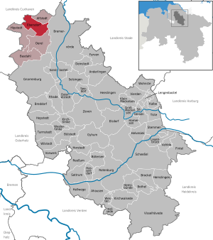
| Location of the community Ebersdorf in the district of Rotenburg (Wümme) | ||
  |
||

Ebersdorf ( Low German Eversdorp ) is a municipality in the combined municipality of Geestequelle in the district of Rotenburg (Wümme) in Lower Saxony .
geography
Geographical location
Ebersdorf is located between Hamburg and Bremerhaven, about eight kilometers northwest of Bremervörde .
Neighboring communities
Ebersdorf borders the city of Geestland in the north, Alfstedt in the northeast, the city of Bremervörde in the east, Oerel in the south and Hipstedt in the west .
Community structure
In addition to the main town of Ebersdorf, the towns of Westerbeck and Neu Ebersdorf also belong to the municipality.
history
The place was first mentioned in a document in 1272. Around 1500 the village belonged to the Börde Oerel under the name Everestorppe . On March 1, 1974, the neighboring community of Neu Ebersdorf was incorporated.
politics
Municipal council
The council of the municipality Ebersdorf consists of eleven council women and councilors. This is the specified number for the member municipality of an integrated municipality with a population between 1001 and 2000 inhabitants. The council members are elected for a five-year term by local elections. The current term of office began on November 1, 2016 and ends on October 31, 2021.
The last local election on September 11, 2016 resulted in the following:
| Political party | Proportional votes | Number of seats |
|---|---|---|
| Common list Ebersdorf | 100% | 11 |
The turnout in the 2016 local elections was 67.77%, above the Lower Saxony average of 55.5%.
mayor
The council elected council member Claus Dieter Wagenlöhner (Ebersdorf Common List) as honorary mayor for the current electoral term.
coat of arms
|
|
Blazon : “In green a golden (yellow) sloping bar covered with a leaping black boar; accompanied above in front of a golden (yellow), black-shod lance tip and below by a golden (yellow) battle ax. " |
| Justification for the coat of arms: The colors green and gold stand for the agricultural character of the municipality; the boar speaks for the place name. The battle ax and the lance tip represent the archaeological finds in the community. |
traffic
The place is on the B 495 , which connects it to Bremervörde via the B 71 / B 74 that runs south .
Web links
Individual evidence
- ↑ State Office for Statistics Lower Saxony, LSN-Online regional database, Table 12411: Update of the population, as of December 31, 2019 ( help ).
- ^ Federal Statistical Office (ed.): Historical municipality directory for the Federal Republic of Germany. Name, border and key number changes in municipalities, counties and administrative districts from May 27, 1970 to December 31, 1982 . W. Kohlhammer GmbH, Stuttgart / Mainz 1983, ISBN 3-17-003263-1 , p. 242 .
- ^ Lower Saxony Municipal Constitutional Law (NKomVG) in the version of December 17, 2010; Section 46 - Number of MPs , accessed on March 6, 2017.
- ↑ a b Ebersdorf municipality - overall results of the 2016 municipal council election , accessed on March 6, 2017.
- ↑ The CDU gets the most votes nationwide. September 12, 2016, accessed March 6, 2017 .
- ↑ Municipalities of the Geestequelle municipality - Ebersdorf municipality , accessed on March 6, 2017.
- ^ Description and reasons for the coats of arms of the Geestequell communities
Ahausen | Alfstedt | Otherlings | Basdahl | Botersen | Bothel | Breddorf | Bremervörde | Brockel | Bülstedt | Deinstedt | Ebersdorf | Elsdorf | Farven | Fintel | Gnarrenburg | Groß Meckelsen | Gyhum | Hamersen | Hassendorf | Heeslingen | Hellwege | Helvesiek | Hemsbünde | Hemslingen | Hepstedt | Hipstedt | Horstedt | Calf | Kirchtimke | Kirchwalsede | Klein Meckelsen | Lauenbrück | Lengenbostel | Oerel | Ostereistedt | Reeßum | Rhade | Rotenburg (Wümme) | Sandbostel | Scheeßel | Seedorf | Singing | Sittensen | Sottrum | Chisel | Tarmstedt | Tiste | Vahlde | Vierden | Visselhövede | Vorwerk | Westertimke | Westerwalsede | Wilstedt | Residential | Zeven