Vorwerk (Lower Saxony)
| coat of arms | Germany map | |
|---|---|---|

|
Coordinates: 53 ° 11 ' N , 9 ° 9' E |
|
| Basic data | ||
| State : | Lower Saxony | |
| County : | Rotenburg (Wümme) | |
| Joint municipality : | Tarmstedt | |
| Height : | 22 m above sea level NHN | |
| Area : | 21.66 km 2 | |
| Residents: | 1048 (Dec. 31, 2019) | |
| Population density : | 48 inhabitants per km 2 | |
| Postal code : | 27412 | |
| Primaries : | 04283, 04288 | |
| License plate : | ROW, BRV | |
| Community key : | 03 3 57 052 | |
| Community structure: | 3 districts | |
| Mayor : | Thomas Müller (WG Vorwerk) | |
| Location of the municipality of Vorwerk in the Rotenburg (Wümme) district | ||
Vorwerk is a municipality in the Tarmstedt municipality in the Rotenburg (Wümme) district in Lower Saxony . It consists of the three districts Vorwerk, Buchholz and Dipshorn , which were independent municipalities until they were incorporated.
geography
The municipality in the Elbe-Weser triangle is located in the west of the Rotenburg (Wümme) district on the border with the Osterholz (north-west) and Verden (south-west) districts. The district town of Rotenburg (Wümme) is east-southeast, and Bremen is to the west-southwest .
Coming from the north-east, the federal highway 1 runs southeast of the municipality boundary to the southwest, where it meets the federal highway 27 at the Bremer Kreuz .
Incorporations
On March 1, 1974, the municipalities of Buchholz and Dipshorn were incorporated.
politics
Municipal council
The council of the municipality of Vorwerk consists of eleven council women and councilors. This is the specified number for the member municipality of an integrated municipality with a population between 1001 and 2000 inhabitants. The council members are elected for a five-year term by local elections. The current term of office began on November 1, 2016 and ends on October 31, 2021.
The last local election on September 11, 2016 resulted in the following:
| Political party | Proportional votes | Number of seats |
|---|---|---|
| WG Buchholz | 43.54% | 5 |
| WG Vorwerk | 40.01% | 4th |
| Flat share Dipshorn | 16.43% | 2 |
The turnout in the 2016 local elections was 73.82%, above the Lower Saxony average of 55.5%.
mayor
The local council elected councilor Thomas Müller (WG Vorwerk) as honorary mayor for the current electoral term. He has been in office since 2011. His predecessor Ernst-August Seeger from the Dipshorn district had been mayor since 1996. His predecessor Hinrich Warjes was mayor of the then independent municipality of Dipshorn from 1948 to 1972 and then of the municipality of Vorwerk from 1972 to 1996 and thus one of the longest incumbent municipality heads in Germany .
Attractions

- Belfry in the middle of the village
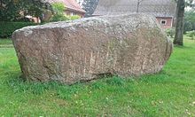
- Findling (Vorwerk) : The Vorwerker Steinriese is a granite stone boulder , which is located next to the belfry; it measures around 4 m × 2 m × 1.5 m and weighs between 31 and 33 tons. The composition of the minerals shows that the stone comes from Vångaberg, which is located near the small town of Vånga near Kristianstad in Skåne County , Sweden . During the Saale glaciation it was carried by the ice masses and deposited in a moraine and covered with sand. He was eventually discovered while plowing. Since he could not stay there in the field, he was transported to the center of the village with the approval of the district archeology.
- Ilexhain (Buchholz) : In Buchholz there is a large Ilexhain that includes around 30 trees.
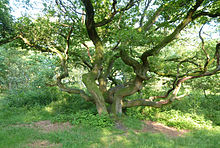
- Kratteichen (Buchholz) : The famous Kratteichen are located on the picturesque Holzberg .
Sons and daughters of the church
- Leander Modersohn (* 1980), German actor
- Fero Andersen (* 1982), presenter of the show Schau dich schlau
Individual evidence
- ↑ State Office for Statistics Lower Saxony, LSN-Online regional database, Table 12411: Update of the population, as of December 31, 2019 ( help ).
- ^ Federal Statistical Office (ed.): Historical municipality directory for the Federal Republic of Germany. Name, border and key number changes in municipalities, counties and administrative districts from May 27, 1970 to December 31, 1982 . W. Kohlhammer GmbH, Stuttgart / Mainz 1983, ISBN 3-17-003263-1 , p. 241 .
- ^ Lower Saxony Municipal Constitutional Law (NKomVG) in the version of December 17, 2010; Section 46 - Number of MPs , accessed on March 10, 2017.
- ↑ a b Municipality of Vorwerk - overall results of the 2016 municipal council election , accessed on March 10, 2017.
- ↑ The CDU gets the most votes nationwide. September 12, 2016, accessed March 10, 2017 .
- ↑ Members of the Vorwerk municipal council ( Memento of the original from March 12, 2017 in the Internet Archive ) Info: The archive link has been inserted automatically and has not yet been checked. Please check the original and archive link according to the instructions and then remove this notice. , accessed March 10, 2017.


