Bülstedt
| coat of arms | Germany map | |
|---|---|---|

|
Coordinates: 53 ° 13 ' N , 9 ° 10' E |
|
| Basic data | ||
| State : | Lower Saxony | |
| County : | Rotenburg (Wümme) | |
| Joint municipality : | Tarmstedt | |
| Height : | 25 m above sea level NHN | |
| Area : | 25.59 km 2 | |
| Residents: | 778 (Dec. 31, 2019) | |
| Population density : | 30 inhabitants per km 2 | |
| Postal code : | 27412 | |
| Primaries : | 04283, 04288 | |
| License plate : | ROW, BRV | |
| Community key : | 03 3 57 010 | |
| Community structure: | 3 parts of the community | |
| Association administration address: | Hepstedter Strasse 9 27412 Tarmstedt |
|
| Website : | ||
| Mayor : | Jochen Albinger | |
| Location of the municipality Bülstedt in the district of Rotenburg (Wümme) | ||
Bülstedt is a Lower Saxon community with 753 inhabitants in the Tarmstedt municipality in the Rotenburg (Wümme) district . In addition to the main town of Bülstedt, the towns of Osterbruch and Steinfeld also belong to the community.
geography
Northeast of Bülstedt there is a 22 hectare large nature reserve " Black Moor at Bülstedt ".
history
The place Bülstedt was first mentioned in 1150.
Incorporations
The municipality of Bülstedt was created in 1929 through the merger of the municipalities of Altenbülstedt and Neuenbülstedt. On March 1, 1974, the neighboring community of Steinfeld was incorporated.
politics
Municipal council
The council of the municipality of Bülstedt consists of nine councilors and councilors. This is the specified number for the member municipality of an integrated municipality with a population between 501 and 1000 inhabitants. The council members are elected for a five-year term by local elections. The current term of office began on November 1, 2016 and ends on October 31, 2021.
The last local election on September 11, 2016 resulted in the following:
| Political party | Proportional votes | Number of seats |
|---|---|---|
| Voting Community Bülstedt (WGB) | 45.75% | 4th |
| Voting Community Steinfeld (WGS) | 25.05% | 2 |
| SPD | 17.43% | 2 |
| Green | 11.75% | 1 |
The turnout in the 2016 local elections was 82.53%, above the Lower Saxony average of 55.5%.
mayor
The council elected council member Jochen Albinger (SPD) as honorary mayor for the current electoral term.
coat of arms
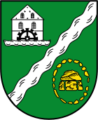
| Blazon : “In green, divided by an oblique left silver (white) wave bar, in front a silver (white) grain water mill with a black four-spoke growing water wheel; behind a golden (yellow) large stone grave, which consists of three supporting stones and a capstone, which is surrounded by a wreath of eighteen golden (yellow) stones. " | |
| Justification of the coat of arms: The wave bar stands for the Bülstedter Mühlenbach on which the water mill is located. The large stone grave symbolizes the megalithic systems in the Steinfeld district. |
flag
 |
Hoisted flag: "The flag is green-white-green in a ratio of 3: 8: 3 stripes with the applied coat of arms in the middle." |
Soil monuments
traffic
Bülstedt is about ten kilometers northwest of the A1 . The K 117 to Wilstedt and the L 132 running through Steinfeld connect the town to the surrounding area.
literature
- Renate Matysiak: Bülstedt - Steinfeld. From the story of two villages. Edition Temmen , Bremen 1992, ISBN 3-926958-92-8
Web links
Individual evidence
- ↑ State Office for Statistics Lower Saxony, LSN-Online regional database, Table 12411: Update of the population, as of December 31, 2019 ( help ).
- ^ Federal Statistical Office (ed.): Historical municipality directory for the Federal Republic of Germany. Name, border and key number changes in municipalities, counties and administrative districts from May 27, 1970 to December 31, 1982 . W. Kohlhammer GmbH, Stuttgart / Mainz 1983, ISBN 3-17-003263-1 , p. 242 .
- ^ Lower Saxony Municipal Constitutional Law (NKomVG) in the version of December 17, 2010; Section 46 - Number of MPs , accessed on March 8, 2017.
- ↑ a b Municipality of Bülstedt - overall results of the 2016 municipal council election , accessed on March 8, 2017.
- ↑ The CDU gets the most votes nationwide. September 12, 2016. Retrieved March 8, 2017 .
- ↑ Members of the Bülstedt municipal council ( Memento of the original from March 9, 2017 in the Internet Archive ) Info: The archive link was automatically inserted and not yet checked. Please check the original and archive link according to the instructions and then remove this notice. , accessed March 8, 2017.
- ↑ Main statute of the municipality of Bülstedt


