Santiago del Teide
| Santiago del Teide municipality | ||
|---|---|---|
 Church of Santiago del Teide
|
||
| coat of arms | Map of the Canary Islands | |

|
|
|
| Basic data | ||
| Autonomous Community : | Canary Islands | |
| Province : | Santa Cruz de Tenerife | |
| Island: | Tenerife | |
| Coordinates | 28 ° 18 ′ N , 16 ° 49 ′ W | |
| Height : | 950 msnm | |
| Area : | 52.26 km² | |
| Residents : | 11,111 (Jan 1, 2019) | |
| Population density : | 212.61 inhabitants / km² | |
| Postal code : | E-38436 | |
| Municipality number ( INE ): | 38040 | |
| administration | ||
| Mayor : | Emilio Navarro ( PP ) (as of 2015) | |
| Address of the municipal administration: | C / La Placeta, 10 38436 Santiago del Teide |
|
| Website : | www.santiagodelteide.org | |
| Location of the municipality | ||

|
||
Santiago del Teide is a city on the Canary Island of Tenerife with 11,111 inhabitants (as of January 1, 2019).
geography
Geographical location
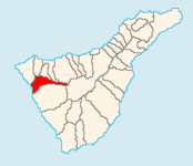
Neighboring municipalities are Buenavista del Norte , Los Silos and El Tanque in the north, Garachico and Icod de los Vinos in the northeast, La Orotava in the east and Guía de Isora in the south.
The municipality of Santiago del Teide has an area of 52.26 km² at an average altitude of 950 m above sea level.
Community structure
The main parts of the municipality are the three tourist centers, which have now grown together, Puerto de Santiago (also called Puerto Santiago), Playa de la Arena and Los Gigantes on the coast, Tamaimo at around 600 meters and the main town of Santiago del Teide itself at around 930 meters. Other districts of Santiago del Teide are Valle de Arriba, Las Manchas, El Molledo, El Retamar and Arguayo, all of which are in the highlands.
climate
The southwestern parts of the municipality Puerto Santiago with Los Gigantes and Playa de la Arena lie in the lee shadow of the Teno Mountains. The climate can be classified as a kind of “subtropical high altitude climate”. Since north-easterly winds usually prevail, this area is almost constantly exposed to a foehn effect due to the Teno Mountains in the northwest . The highest temperatures in the Canary Islands are measured here, combined with most hours of sunshine in the archipelago. In return, the area around Santiago is exposed to heavy rainfall during (rather rare) southwest weather conditions, which occur preferably in winter between November and February and can occasionally be stormy.
history
After the Spanish conquered Tenerife, the area around today's Santiago del Teide belonged to Buenavista del Norte . In 1552 12 people lived in this area. In the 17th century , a new church was built from an older chapel, which was dedicated to St. James ( Santiago in Spanish ). On September 9, 1679, the municipality officially gained its independence from Buenavista del Norte. In the 18th century, Santiago del Teide was considered one of the poorest places in Tenerife. In 1776 Adeje ceded a large piece of wasteland to Santiago, which was cultivated by the neighboring villages for payment.
In 1916 the place, which until then officially only bore the name Santiago , was officially given the addition of del Teide . In the 20th century, Santiago del Teide experienced an economic and demographic boom, the population grew from 1,432 inhabitants in 1900 to 3,414 in 1970. The city was also connected to the road network in 1930 and water pipes in 1950. Santiago del Teide has also benefited since the 1960s from tourism, especially in the coastal towns. Shortly after the turn of the millennium, the number of inhabitants exceeded the 10,000 mark.
Population development
| year | Residents | Population density |
|---|---|---|
| 1991 | 5,914 | |
| 1996 | 7.506 | |
| 2001 | 9,303 | 178.9 inhabitants / km² |
| 2002 | 10.113 | |
| 2003 | 10,523 | 201.55 inhabitants / km² |
| 2004 | 10,777 | 206.2 inhabitants / km² |
| 2005 | 11,212 | |
| 2006 | 11,379 | |
| 2007 | 11,493 | |
| 2008 | 11,825 | |
| 2009 | 12,050 | |
| 2010 | 12,099 | |
| 2014 | 10,468 | 200.3 inhabitants / km² |
| 2016 | 11,338 | 216.95 inhabitants / km² |
traffic
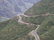
Since the completion of the section from Guía de Isora to Santiago del Teide in 2015, the TF-1 ( Autopista del Sur ), which leads via Adeje to the island's capital Santa Cruz de Tenerife , has ended in Santiago del Teide . In order to establish a connection to the TF-5 ( Autopista del Norte ), the motorway is to be extended to El Tanque through a tunnel several kilometers long. However, it is unclear when this construction project, which has already started, can be completed, as the island government cannot fully finance the construction. In addition, country roads lead from Santiago del Teide via Masca to Buenavista del Norte and via El Tanque to Icod de los Vinos .
particularities
The municipality of Santiago del Teide had a foreign share of 52% in 2011, more than any other municipality in Spain.
Individual evidence
- ↑ Cifras oficiales de población resultantes de la revisión del Padrón municipal a 1 de enero . Population statistics from the Instituto Nacional de Estadística (population update).
- ↑ El PP mejora sus resultados en Santiago del Teide y obtiene mayoría absoluta, eldiario.es , accessed on April 16, 2017
- ↑ Santiago del Teide: Población , accessed April 16, 2017
- ↑ Historia del Municipio, santiagodelteide.org , accessed April 16, 2017
- ^ Instituto Nacional de Estadística
- ↑ Tenerife News: 320 million euro hole: Tenerife's tunnel dilemma. Retrieved April 15, 2017 .
- ↑ Más extranjeros que españoles en Santiago del Teide y Adeje. In: La Opinión de Tenerife. laopinion.es, April 7, 2011, accessed August 9, 2018 (Spanish).

