Arafo
| Arafo municipality | ||
|---|---|---|
| coat of arms | Map of the Canary Islands | |

|
|
|
| Basic data | ||
| Autonomous Community : | Canary Islands | |
| Province : | Santa Cruz de Tenerife | |
| Coordinates | 28 ° 20 ′ N , 16 ° 25 ′ W | |
| Height : | 470 msnm | |
| Area : | 34.27 km² | |
| Residents : | 5,551 (Jan 1, 2019) | |
| Population density : | 161.98 inhabitants / km² | |
| Postal code : | 38550 | |
| Municipality number ( INE ): | 38004 | |
| administration | ||
| Mayor : | Domingo Calzadilla ( PP ) | |
| Address of the municipal administration: | Plaza José Antonio, 4 38550 - Arafo |
|
| Location of the municipality | ||

|
||
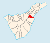
Arafo is a municipality in the northeast of the Canary Island of Tenerife . It is connected to the island's capital, Santa Cruz de Tenerife, via the TF-1 southern motorway and the old Santa Cruz de Tenerife - Adeje road. Arafo is located southeast of Santa Cruz de Tenerife. Neighboring municipalities are La Victoria de Acentejo in the northwest, Candelaria in the north, Güímar in the south and La Orotava in the west.
The municipality of Arafo has an area of 33.92 km² at an average altitude of 450 m above sea level.
Residents
| year | Residents | Population density |
|---|---|---|
| 1991 | 4,200 | - |
| 1996 | 4,667 | - |
| 2001 | 4,995 | 147.3 inhabitants / km² |
| 2002 | 5,156 | - |
| 2003 | 5.122 | 151 people / km² |
| 2004 | 5,256 | 155.0 inhabitants / km² |
| 2005 | 5,276 | 155.5 inhabitants / km² |
| 2006 | 5,257 | 155.0 inhabitants / km² |
| 2007 | 5,310 | 156.5 inhabitants / km² |
| 2014 | 5,464 | 159.4 inhabitants / km² |
Web links
Individual evidence
- ↑ Cifras oficiales de población resultantes de la revisión del Padrón municipal a 1 de enero . Population statistics from the Instituto Nacional de Estadística (population update).
