Garachico
| Garachico municipality | ||
|---|---|---|
 Glorieta de San Francisco with the Casa de la Quinta Roja
|
||
| coat of arms | Map of the Canary Islands | |

|
|
|
| Basic data | ||
| Autonomous Community : | Canary Islands | |
| Province : | Santa Cruz de Tenerife | |
| Island: | Tenerife | |
| Coordinates | 28 ° 23 ′ N , 16 ° 45 ′ W | |
| Height : | 10 msnm | |
| Area : | 29.28 km² | |
| Residents : | 4,871 (Jan 1, 2019) | |
| Population density : | 166.36 inhabitants / km² | |
| Postal code : | E-38450 | |
| Municipality number ( INE ): | 38015 | |
| administration | ||
| Mayor : | Ramón Miranda Adán ( CC ) (as of 2005) | |
| Address of the municipal administration: | Plaza la Libertad, 1 38450 Garachico |
|
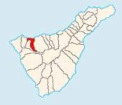
| Location of the municipality | ||

|
||
Garachico is a town in the northwest of the Canary Island of Tenerife with 4871 inhabitants (as of January 1, 2019) and via the TF-42 road , which leads from Buenavista del Norte to Icod de los Vinos , with the TF-5 ( Autopista del Norte ), which leads to Santa Cruz de Tenerife . The city continues to call itself after the old name Villa y Puerto de Garachico .
Neighboring communities are Icod de los Vinos in the east, Santiago del Teide in the south and Los Silos and El Tanque in the west.
The municipality of Garachico has an extension of 29.28 km² at an average height of 10 m above sea level.
history
The town of Garachico with its port was founded immediately after the conquest of Tenerife in 1496 by the Genoese banker Cristóbal de Ponte (1447–1531). Garachico's first economic basis was sugar cane and its processing.
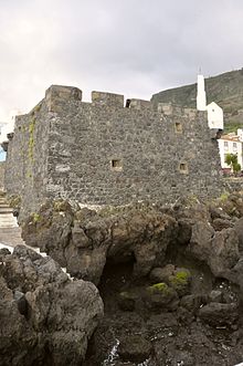
In 1520 the construction of the Iglesia de Santa Ana , as the main church, began. In an extension of the church there is now a small museum with sacred objects. In the 16th and 17th centuries, Garachico developed into the most important port on the island. a. English buccaneers built the still intact port fortress the Castillo de San Miguel in 1575 . The export of Malvasia wine, especially to England, was essential for the activity at that time . The prosperity from the trade of that era allowed generous endowments; in the 18th century there were five monastic communities.
1645 was the first fateful year in a series of catastrophes, when around 80 people were killed and 40 ships were sunk by a huge storm surge. The unrest of 1666 also had a negative effect on trade and prosperity, when locals angry against the English merchants smashed the wine barrels in the port of Garachico for shipping. In 1697 a fire raged in the city and destroyed over a hundred houses.
The end of Garachico as a trading center came on May 5, 1706 with the eruption of the Montaña del Estrecho (Volcán Garachico) above the town, during which the lava masses buried the port of Garachico for the most part. Only the church and monastery of San Francisco from the 16th century, the oldest buildings in the town, on the Plaza Glorieta de San Francisco , were spared from the lava masses. Then the traders moved to Puerto de la Orotava, today's Puerto de la Cruz . Many residents became impoverished and emigrated to the Spanish colonies on the other side of the ocean.
A new, small but modern port for fishing and private boats has been in operation since 2012. This was protected on the sea side by a large pier.
Attractions
- The entire place is worth seeing, especially its quiet, traffic-free pedestrian zone.
- In the monastery church of San Francisco, the wooden ceiling in Mudejar style and some sculptures are impressive .
- The former monastery now houses the town hall and the city museum with a typical Canarian courtyard with palm trees and galleries. The museum also proves that money was not only made from exporting wine, but also from the black gold , the slave trade.
- In front of the Castillo, the lava cliffs were fortified and paved with walkways. There is also a seawater swimming pool here.
- Inner courtyard of Casa Quinta Roja opposite the monastery and church, today a hotel.
- Santa Ana Church from the 18th century. Its predecessor, like all the buildings to the west of it, was robbed by the lava masses of 1706. There is a small museum in the extension of the church.
- "Parque de la historica Puerta de Tierra" - The former city gate that was left after the 1706 earthquake. It is deeper than the rest of the city, so that today you can see very well how deep the old Garachico was buried by the lava.
- The Calle Esteban Ponte runs parallel to the coastal road and houses the Hotel San Roque in two carefully restored mansions of the Ponte family.
- You get a very special impression of the small town from above. Here the hiking trail TF-43 is recommended, which leads past the town hall and the police station up the mountain.
Population development
| year | Residents | Population density |
|---|---|---|
| 1991 | 5,993 | 204.7 inhabitants / km² |
| 1996 | 5,728 | 195.6 inhabitants / km² |
| 2001 | 5,307 | 181.3 inhabitants / km² |
| 2002 | 5,742 | 196.1 inhabitants / km² |
| 2003 | 5,756 | 196.6 inhabitants / km² |
| 2004 | 5,671 | 193.7 inhabitants / km² |
| 2005 | 5,682 | 194.1 inhabitants / km² |
| 2006 | 5,543 | 189.3 inhabitants / km² |
| 2007 | 5,446 | 186.0 inhabitants / km² |
| 2014 | 5,169 | 176.5 inhabitants / km² |
Impressions
View of Garachico and its landmark Roque de Garachico , the rock in front of it
swell
- ISTAC (Statistical Department of the Regional Government of the Canary Islands)
- Hike from Garachico to San Juan del Reparo
Web links
Individual evidence
- ↑ Cifras oficiales de población resultantes de la revisión del Padrón municipal a 1 de enero . Population statistics from the Instituto Nacional de Estadística (population update).


