
Puerto de Santiago
| Santiago del Teide municipality: Puerto de Santiago | |||
|---|---|---|---|
.jpg)
|
|||
| coat of arms | Map of the Canary Islands | ||
 Help on coat of arms |
|
||
| Basic data | |||
| Autonomous Community : | Canary Islands | ||
| Province : | Santa Cruz de Tenerife | ||
| Island: | Tenerife | ||
| Coordinates | 28 ° 14 ′ N , 16 ° 50 ′ W | ||
| Residents : | 5,495 (2011) INE | ||
| Postal code : | 38689 | ||
| Area code: | 38040000400 | ||

Puerto de Santiago (short Puerto Santiago ) belongs to the municipality of Santiago del Teide in the province of Santa Cruz de Tenerife . The place is located on the west coast of the Canary Island of Tenerife directly on the Atlantic Ocean , about 10 kilometers south of the main town and about eight kilometers north of Playa San Juan .
tourism
The district has undergone the transformation from a fishing village to a tourist area in recent years . Numerous new buildings for holiday apartments and hotel complexes bear witness, although a certain authenticity can still be attested, as there is still a small fishing port. The place has now almost completely merged with the north and south of Los Gigantes and Playa de la Arena to form a large tourist center.
Population development
The following table gives an overview of the population development in Puerto de Santiago since 2000.
| 2000 | 2001 | 2002 | 2003 | 2004 | 2005 | 2006 | 2007 | 2008 | 2009 |
|---|---|---|---|---|---|---|---|---|---|
| 3491 | 3817 | 4157 | 4329 | 4451 | 4729 | 4896 | 4987 | 5224 | 5386 |
gallery

Puerto de Santiago fishing port

Fisheries Museum
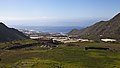
View from the Teide National Park to Puerto de Santiago

Panorama from the lower part of Puerto de Santiago


Web links
Individual evidence
- ↑ Instituto Nacional de Estadística ( Memento of the original from March 4, 2016 in the Internet Archive ) Info: The archive link was inserted automatically and has not yet been checked. Please check the original and archive link according to the instructions and then remove this notice. - Demographic statistics of the Instituto Nacional de Estadística (Spanish)