
Burglesum
| District of Bremen Burglesum |
||
|---|---|---|
  |
||
| Basic data | rank | |
| Surface: | 25.831 km² | 3/23 |
| Residents : | 33,107 | 8/23 |
| Population density : | 1,282 inhabitants per km² | 17/23 |
| Proportion of foreigners: | 12.7% | 14/23 |
| Unemployment rate: | 12.6% | 8/23 |
| Coordinates : | 53 ° 9 ' N , 8 ° 42' E | |
| Districts: |
Burg-Grambke Werderland Burgdamm Lesum St. Magnus |
|
| Height : | 30 m above sea level NN | |
| Postcodes : | 28717, 28719, 28757, 28759 | |
| District : | North | |
| Local office : | Burglesum | |
| Website: | Burglesum local office | |
| All area information as of December 31, 2014. All demographic information as of December 31, 2016. |
||

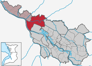
Burglesum ( Low German Borgleessem ) is a district of Bremen within the northern district .
Geography and districts
Geography of the district
In the northeast, the district through which the Lesum flows is bordered by the Lower Saxony municipality of Ritterhude , in the northwest by the Lower Saxony municipality of Schwanewede , in the west by the Vegesack district and in the south (from west to east) by the districts of Häfen , Gröpelingen and Blockland .
The district is characterized by abruptly changing landscapes. The districts south of the Lesum - Burg-Grambke and Werderland - are located in a marshland with a height of 1 to 2 m above sea level. NHN , parts of Burg-Grambkes (especially the more densely built-up areas) but on a drifting sand dune, which is up to a height of 6 m above sea level. NHN rises. The districts north of the Lesum - St. Magnus, Lesum and Burgdamm - are part of Bremen Switzerland . The sharp southern edge of the Wesermünder Geest runs here . The 32.5 m above sea level NHN, the highest natural elevation in the Free Hanseatic City of Bremen, is located on the Geest in the Friedehorstpark in the St. Magnus district . The Geestrand along the Lesum in the course of the Admiral-Brommy-Weg shows an impressive difference in altitude for flat land: the 20-meter height line is in places less than 150 m away from the level of the marsh. The street names Auf dem Hohen Ufer and Barg up have their origin here.
The Geestrücken itself also has considerable structures in the district. The Geestbach Ihle flows in a narrow valley, the base of which is about 10 m below the level of the flanking areas. Lesum, Burgdamm and Burg-Grambke lie above the Lesum salt dome . Several sinkholes , which arose as a result of broken cavities in the gypsum dome of the salt dome, are still visible today through circular depressions in the landscape. The extent of these sinkholes is exemplified by the Ruschdahlmoor : Here, a raised bog has arisen in a sinkhole to which the nutrient-poor rainwater from the surrounding area flowed . The depression measures about 200 m in an east-west direction. Its eastern flank rises steeply - sometimes over a distance of less than 25 m - by 10 m. In the Ruschdahlmoor 21 m thick layers of peat were discovered by drilling. It can therefore be assumed that the total depth of the sinkhole is about 30 m.
The district of Burglesum is divided into the districts of Burg-Grambke, Werderland, Burgdamm, Lesum and St. Magnus:
Burg-Grambke

Area: 4.57 km², 6696 inhabitants
The district is located south of the Lesum between the Blockland and the Werderland . It also has typical village structures and is often called the “village within the city”. The Grambker Church was built in the Baroque style in 1722 and a neo-Gothic tower was added in 1864 . The large school center Alwin-Lonke-Straße is located in the district .
In Burg-Grambke there are the Grambker See , the Grambker Feldmarksee , the Sportparksee Grambke and the Burger See, which is divided into two by the Bremen – Bremerhaven railway line .
The Feldmarksee is surrounded by birch , ash and a natural reed belt . The Sportparksee Grambke, excavated in 2002, is much larger and measures around 1.2 km in length. Due to its good water quality, it is suitable for swimming and has been provided with appropriate facilities, such as. B. a DLRG station. In contrast to the Feldmarksee, it is much quieter and more secluded.
Burg-Grambke borders on the Bremen industrial park, in which, among other things, Arcelor Bremen (formerly Klöckner-Hütte or Stahlwerke Bremen) is located. The remaining parts of the industrial area were built on land that had belonged to the steelworks as reserve area for many years, but was not used.
Werderland


Area: 10.94 km², 393 inhabitants
The Werderland district, located between the rivers Lesum and Weser, consists of an open, tree-poor marshland . The village of Lesumbrok stretches along the Lesum , further south on the Weser the village of Niederbüren and the rest of the village of Mittelbüren, which was largely abandoned in the 1950s as part of the industrial settlement in Werderland . A farmhouse from the 16th century that was dismantled there was rebuilt in the original in the park of the Focke Museum in Bremen-Schwachhausen and can be visited. The area around the Moorless Church, built in the neo-Gothic style in 1846/47 (= Low German for “motherless”, i.e. single church), with a ship landing stage, has been preserved from Mittelbüren .
The eastern part of Werderland was spun off from the district in the 1950s with the construction of the Klöckner-Werke, now ArcelorMittal Bremen GmbH, and added to the ports district as the industrial ports district. In 1996, the central Werderland was designated as a nature reserve. The Schönebecker Sand , the peninsula between Weser and Lesum with a former bathing establishment, is also under nature protection . With Vegesack the Werder country is through the Lesum barrage connected, built 1971-1974 for flood protection.
Castle dam
Area: 4.17 km², 10,943 inhabitants
The municipality of Burgdamm was created in 1860 from the municipalities of Marßel, Burgdamm and Vorburgdamm. Burgdamm was incorporated into the municipality of Lesum on June 1, 1936 and came to the city of Bremen as part of Lesum in 1939. Today the district essentially consists of two quarters that are separated by the A 27 :
Between the A 27 and the Bremerhaven Heerstraße to the west, including both sides of the Stader Landstraße, lies an area on the Geest that is predominantly characterized by older buildings. The railway line to Bremerhaven runs south of it, below the Geest edge. Agricultural grassland predominates in the area of the marshland. There is an industrial park on both sides of the 1388-built Steindamm, which led from the castle to Marßel. Bremen-Burg station is to the west of it.
East of the A 27 is the Marßeler Feld , or Marßel for short. In the 1960s, as part of social housing, a large housing estate corresponding to the times was built for around 6,000 inhabitants today. The district sports facility is located at Pellenspark in Marßel . The district borders on Ritterhude and Ritterhuder Switzerland with the Hamme as the source of the Lesum, which forms the southern border of the district.
Lesum

Area: 3.37 km², 9097 inhabitants
Lesum is also called Lesmona in Latin. Lesum is the historical and cultural center; the local office is located here.
The St. Martini Church located on a hill in the center of the old Lesum cemetery , surrounded by tombstones from the 17th to 19th centuries, is worth seeing . The Romanesque tower from around 1200 has been preserved from the original building . The nave was redesigned as a baroque hall in 1778/1779.
St. Magnus

Area: 2.86 km², 5878 inhabitants
St. Magnus was an independent municipality until its incorporation into the municipality of Lesum on June 1, 1936 and came to the city of Bremen as part of Lesum in 1939. Previously, in 1908, the two communities Friedrichsdorf and Neu Schönebeck had been incorporated into the community of St. Magnus.
St. Magnus is now a green and quiet residential area on the Lesum.
The summer cultural festival in Lesmona has been taking place in the 65-hectare Knoops Park since 1994 , with the Deutsche Kammerphilharmonie Bremen giving open-air concerts. The park is named after the factory owner Baron Ludwig Knoop , the former owner of the site. The part of the park, which adjoins the Lesum river, with the listed classicist house Lesmona, is the actual setting for the main plot of the autobiographical novel Summer in Lesmona by Marga Berck , which was filmed with Katja Riemann .
In Friedehorstpark (also called Lehnhofpark), which takes up an area of approx. 9 hectares , is the 32.5 m above sea level. NHN highest natural elevation in the Free Hanseatic City of Bremen.
The main church of the Evangelical Lutheran parish of St. Magni is located in St. Magnus , which belongs to the Bremen Evangelical Church and, in addition to the St. Magnus district, also includes the Schönebeck district, which belongs to the Vegesack district, and parts of the Schwanewede community in Lower Saxony . The modern, simple church building from 1967 was placed under monument protection in the mid-1990s.
Politics, administration
Advisory Board
The Burglesum Advisory Board meets regularly and usually in public in the meeting room of the local office. The advisory board is composed of the representatives of the political parties or individual candidates elected at the district level. The advisory board elections take place every four years, at the same time as the elections for the Bremen citizenship . The advisory board discusses all issues of the district that are of public interest and makes decisions on this, which are passed on to the administration, the state government and the townspeople. He forms specialist committees for his work. The advisory board has its own budget for district-related measures.
The advisory board spokesman is Martin Hornhues (CDU).
Local office
The local office Burglesum has been the local administrative authority since 1946, which carries out local tasks that are of public interest. It is led by a local office manager proposed by the local council and confirmed by the senate. In 2012 Florian Boehlke (SPD) was appointed head of the local office.
history
The names
- Lesum was called 860 Liastmona , and 1062 Liestmunde , 1083 Liesmunde and around 1187 also Lesmona . That means: located at the mouth of the Lieste , i.e. the Lesum .
- Lesumbrok was 1243 Lesmundbroke , 1311 Lesmerboke and 1385 Lesmunderbroke . It was the quarry land colonized from Lesum, i.e. a marshland . Here is the oldest Lower Saxony house in Bremen, the Spiegelhof from 1667.
- The castle was called Borch in 1277 and Borgh in 1371 . The location of the first castle is not known. In the middle of the 14th century, the archbishop and town built a new castle together. In 1350, the Archbishop provided Gohe Blockland and Werderland, which had previously been subordinate to the Archdiocese, for their maintenance.
- Burgdamm ( Borchdamm upen damm ) was the dam built in 1388 north of the Lesum from the Geestrand to the bridge, still marked today by the Steindamm street .
- Grambke was called Grambeke around 1200 (1222: Grambecke ) and was the name of a family of ministers who had their seat here.
- Grambkermoor was mentioned as More in 1281 and the inhabitants were de bur thon More .
- St. Magnus is derived from the medieval chapel of St. Magnus (now St. Magni). There is no evidence of which Saint Magnus gave the chapel its name.
- Werderland is generally a stretch of land between a river and standing water. Werderland used to be an island that was formed by an arm of the Weser. The name has been handed down since the 14th century.
- Marßel was called Mercele in 1243 and Marsele in 1388 and was the name of a knightly family whose members were ministerials to the Archbishop of Bremen around 1185.
- Dunge was 1309 Dunck and 1334 Dungen called.
Prehistory and early history
The landscape was shaped by several ice ages of the Pleistocene and the warm periods in between. The ice ages completely redesigned the landscape and also influenced the course of the Weser and Lesum rivers . The retreating ice ages opened the way for the glacial valley of the Weser to the north again. The glacial valley also shaped the Burglesum landscape.
Around 300-200 BC BC took place - evidenced by finds - the settlement by the Germanic Chauken . Around 350 AD the Chaukenstaat fell into disrepair and became part of the Saxon tribal association (from the 16th century Lower Saxony ). Excavation finds from 1992 in Grambke ( Oslebshauser Heerstraße / Autobahn A 281 ) show mine houses and weaving houses from the Saxon period around 500.
Around 550 the Saxons invaded England from this area as well . Frisians also increasingly settled in this area. During excavations in the 1990s on Grambker Dorfstrasse, Friesian ceramics from 700 to 900 and a well from 850 were found.
From the Middle Ages to 1600
First mentions
The first documentary mentions were of Lesum around 860, of Grambke in 1185, of Lesumbrok in 1201, of the castle on the Lesum in 1277, of Grambkermoor as More in 1281, of Werderland in the 14th century, of St. Magnus in the middle of the 14th century and von Burgdamm ( dam ) 1388. The estates Groß- and Kleindunge were first mentioned in 1139.
Lesum's beginnings
- Lesum was first mentioned around 860. It was an imperial fiefdom, to which 700 Hufen belonged along the Weser to around Cuxhaven and in the Land of Hadeln. Counts from the Billunger family were enfeoffed with Lesum , most recently Count Liudger, who died in 1011. His widow, Saint Emma of Lesum , kept Lesum as a widow's fief.
- After her death in 1038, Lesum reverted to the kingdom and was initially used to support the respective queen.
- In 1062 King Heinrich IV gave the royal court Lesum (Liestmunde) with the 700 hooves to the Archbishop of Bremen Adalbert . Adalbert built a chapel and dedicated it to Saint Magnus.
- Lesum was an independent parish . The church of St. Martini was first mentioned in 1235, but it is certainly older. From 1235 it belonged to the Cistercians . From the 14th century it belonged to the Bremen cathedral chapter . In 1778 the nave was torn down and rebuilt as a baroque hall building. Only the tower from the Middle Ages remained.
The Goh Werderland
- The Werderland formed a Goh that reached from Utbremen to Burg, led by "Gohgräfen" as judges, who were formerly archbishop ministers from Gröpelingen, among others. In the 15th century, the Bremen council was responsible. The district court met at the church in Burg. In 1741 the northern part of Werderland fell to the Electorate of Braunschweig-Lüneburg (later Hanover). In 1803 the Goh came to Bremen due to the Reichsdeputationshauptschluss and existed until 1811. The Goh included the villages of Burg, Burgdamm, Grambke, Grambkermoor, Lesumbrok and Dunge.
- At the Lesumübergang there was a castle (Borch) in the 13th century, around which the village of Burg developed. The Church of St. Nicholas was founded here in the 13th century.
- In 1350 a bridge was built over the Lesum and in 1388 a dam was built that opened up the Lesum Geest; Burgdamm began to develop as a village here.
- The village of Grambke belonged to the ore monastery of Bremen and in the 15th century to the Goh Werderland.
- The village of Gramkermoor was also in the Goh Werderland. It remained an independent municipality until 1850.
- The village of Lesumbrok was not built until the dyke was built in the 13th century, when it was possible to settle on the marshland. Until 1871 it was an independent municipality.
- The village of Dunge initially consisted only of two estates, small and large dungeons, and a farm. In the 14th century, the goods were in civil or ministerial ownership. Gut Großdunge was acquired by Syndikus Johann Camp in the 17th century and by the Iken family around 1807. Dunge was an independent municipality until 1851 when it came to Grambke. Großdunge belonged to the parish of Lesum and from 1823 to Grambke, and Kleindunge to the parish of Burg.
St. Magnus
In the Johan Rode Bok from around 1500, St. Magnus is listed among the destroyed castles of the Archbishopric of Bremen. The castle was presumably located on the Kapellenberg next to the farmyard, which today is reminiscent of Meierhofstrasse and Gut Weilen. This could have been the widow's residence of Emma von Lesum . In the 14th century the goods came to the cathedral chapter and in the 17th century to the Lords of Schönebeck. In the middle of the 14th century the Chapel of St. Magnus was created through the Lesum Church, the church patronage changed many times ( Lilienthal monastery , cathedral, St. Ansgarii). It fell into disrepair after the Reformation and was later completely eliminated.
1600 to 1800

- During the First Bremen-Swedish War in 1654, Swedish troops attacked the strategically important Lesum crossing at Burg and occupied the Burger Schanze on April 2nd . On June 15, the fortification could be recaptured by Bremen troops, but fell again into Swedish hands after a siege on September 5. When the position was shot at, the Burger Church was also destroyed. The castle and the castle dam were now part of the Grambke parish . The parish school of Grambke was also responsible for the villages of Burg, Burgdamm and Grambkermoor. A new schoolhouse was not built in Burg until 1674. In 1809 the school was relocated to Burg.
- The Swedes took over territorial sovereignty over the area around Burglesum as the Duchy of Bremen from 1666 . For a short time from 1712 to 1715 Denmark was sovereign here and from 1715 the Elector of Braunschweig-Lüneburg , whose duchy was later dubbed the Electorate of Hanover.
- In 1686 the Lesum Bridge was destroyed by ice during the November flood .
- In the 17th century there was a mill in Burgdamm.
- The baroque church in Grambker was built in 1722 and a neo-Gothic tower from 1864 was added in 1864.
- In 1780 there were only three houses on the Burger Schanze, which was leveled in 1784. There are now 17 settler sites and a school in the area. The Bossesche Werft , which built sailing boats, was founded on the Lesum .
1800 to 1900
- In 1803, Burg, Grambke, Grambkermoor, Mittelbüren and Niederbüren became Bremen's rural area. In 1804 a Dutch mill was built in Burgdamm. From 1810 to 1813 the area was under French rule.
- Around 1812/15 Grambke and Burg had 687 inhabitants and Lesum 445 inhabitants.
- The construction of a new wooden bridge over the Lesum took place during this time.
- In 1813 the Wilkens tobacco factory relocated from Bremen to Burgdamm and stayed there until 1910.
- In 1810 the important pastor Georg Treviranus was selected by the Bremen Senate as pastor in the parish of Grambke-Mittelbüren. In 1814 he went to the St. Martini parish in Bremen.
- The road from Walle to Burg, planned by construction director Nicolaus Blohm from 1820 , was built in the section Oslebshausen to Burg in 1822 under the direction of Friedrich Moritz Stamm , along with the road house in Grambke to collect the road toll. The Chaussee became the later Bundesstraße 6 .
- From the middle of the 19th century the area north of the Lesum began to industrialize, favored by the fact that Bremen was not part of the German customs area . A wool laundry, cigar and porcelain factories are located in Lesum and Burgdamm in Hanover. The Bremen rural areas south of the Lesum remained predominantly rural.
- The Baron Ludwig Knoop bought the Mühlenthal estate in St. Magnus in 1860 . He and other wealthy Bremen residents built villas on the high banks of the Lesum.
- Mayor Johann Smidt acquired the Kleindunge estate in the middle of the 19th century . The estate burned down in 1885.
- In 1850 Gramkermoor came to Grambke, was then self-employed again from 1871 to 1888, then with Grambke until 1921, then self-employed again until 1939 and then with Bremen.
- In 1852 St. Magnus belonged to the Lesum district, in 1885 to the Blumenthal district , in 1939 to Bremen and from 1946 to the Bremen district of Burglesum.
- In 1860 the municipality of Burgdamm was created from the municipalities of Marßel, Burgdamm and Vorburgdamm.
- In 1866 Lesum, St. Magnus and Burgdamm became Prussian. In 1871 the village of Lesumbrok was united with Dunge; it came to Grambke in 1889.
- The customs connection of Bremen in 1888 meant industrial standstill for Lesum and Burgdamm, as industry settled in Bremen.
- The first iron bridge over the Lesum was built from 1892 to 1893.
Schools:
- In 1809 a new single-class school for 27 children was built in Burg.
- In 1820 a one-class school was set up in St. Magnus on Kapellenberg and in 1885 a new building was built.
- In 1825 a two-class school for 200 pupils was built between Grambke and Burg for both villages. Another school building had to follow in 1872 and another school building with six classes and a gym in 1898/1902.
- At the beginning of the 19th century, Lesumbrok only had a small secondary school in the parish of Lesum, which from 1824 - like the parish - switched to the parish of Vegesack.
- Burgdamm received a new school in 1862 and Lesumbrok in 1872/73.
From 1900
- In 1905 Grambke with Gramkermoor, Dunge and Lesumbrok had 1,620 and the entire area of today's Burglesum 6,599 inhabitants.
- Voluntary fire brigades were founded in 1912 in Burgdamm, 1913 in St. Magnus and 1936 in Grambkermoor and Lesumbrok.
- In 1903, the pharmacist Wilhelm August Egeling (1861–1929) was granted a license and since 1904 has been running the Burg pharmacy on Burger Heerstrasse .
- In 1921 the Bremen rural communities of Burg and Grambke were incorporated into the city of Bremen and in 1939 the previously Prussian-Hanoverian communities of Lesum, St. Magnus and Burgdamm were incorporated into Bremen as a result of the fourth ordinance on the rebuilding of the empire . The Bremen rural communities Büren (Mittelbüren), Grambkermoor and Lesumbrok with Dunge were also incorporated into the city of Bremen.
- During the Nazi regime, Fritz Johann Köster, (born September 27, 1906), SA-Hauptsturmführer , was Nazi mayor of the municipality of Lesum from 1934 to 1939. He was u. a. responsible for the murder of three Jews in Burgdamm and Platjenwerbe in the pogrom night of November 9, 1938. The Jews murdered on Fritz Koester's orders were the respected Jewish doctor couple Adolph Goldberg and his wife Martha, as well as the Platjenwerber chief mechanic Leopold Sinasohn.
- From 1939 to 1945, forced laborers from the occupied territories and prisoners of war had to work at the Norddeutsche Hütte . They lived in the Riespott camp in Werderland.
- In 1947 the diaconal care and rehabilitation facility Friedehorst opened its business, today one of the largest employers in the district.
- Magdalene Pauli (1875–1970) published the autobiographical letter novel Sommer in Lesmona in 1951 under the pseudonym Marga Berck in Christian Wegner Verlag.
- In 1957 the village of Mittelbüren was largely given up in favor of the Klöcknerhütte. The neo-Gothic Moorlose Church from 1846/47 was preserved.
- The so-called " rubber station " in Burgdamm was a junction for arriving intercity buses and the buses and trolley buses going into the center of Bremen from the Second World War until the 1960s .
It was later renamed Goldbergplatz after the Jewish couple Goldberg, who was murdered by the Nazis in the Night of the Reichspogrom and who had a medical practice nearby. - In 1960 Burglesum had 26,693 inhabitants.
- The construction of the Marßeler Feld settlement with 2,300 apartment buildings and 300 single-family houses by Gewoba and Brebau took place from 1963 to 1968.
- The Lesum barrier was built in 1971 for flood protection reasons.
- With the A 270 as a city motorway for Bremen-Nord , the districts of Burglesum, Vegesack and Blumenthal were connected to the German motorway network from Ihlpohl .
- Parts of the Werderland were designated as a nature reserve in 1996 .
Schools:
- In 1951 a new school was built in Burgdamm on Stargarder Strasse, which was given a gymnasium in 1958 and an extension in 1963.
- The old school on Grambker Heerstraße was given a gym in 1952.
- The school Am Mönchshof on Hindenburgstrasse was established in Lesum in 1960 .
- In 1962 the St. Magnus School received an extension.
- In 1965, the Lesum high school in Steinkamp (today the Lesum School Association ) was completed as a new building for the high school on Kirchheide in Vegesack , which was expanded as a school center for secondary level II in 1975 on Bördestrasse.
- In 1966 the special school was set up on Louis-Seegelken-Straße .
- In 1969 the construction of a school center began in Grambke on Alwin-Lonke-Strasse.
- In 1971 the Vor dem Heisterbusch school was established (today the Lesum School Association).
Population development
Today's district and today's districts in bold
| Villages, districts | 1812 | 1821/58 | 1885 | 1905 | 1975 | 1995 | 2007 |
|---|---|---|---|---|---|---|---|
| Castle | 135 | 288 | |||||
| Grambke Grambkermoor Lesumbrok |
283 71 133 |
546 51 204 |
additional 1,620 |
||||
| Burg-Grambke | 5,755 | 6,931 | 6,796 | ||||
| Marssel | 48 | 1858: 383 | ≈9,000 | ||||
| Castle dam | 1821: 61 | 1,560 | 12,727 | 11,388 | 10,973 | ||
| Lesum | 445 | 1858: 1079 | 2,169 | 11,035 | 9,726 | 9.119 | |
| St. Magnus | 1821: 313 | 549 | 1,250 | 5,493 | 5,969 | 5,851 | |
| Werderland | 297 | 356 | 389 | ||||
| Burglesum | 35,306 | 34,370 | 33,128 |
Culture and sights

Buildings
- Evangelical St. Martini Church in Lesum, mentioned for the first time in 1235, but older original building. The Romanesque tower has been preserved from the original building; the nave was rebuilt from 1778 to 1779 according to plans by Johann Diercks.
- Evangelical Grambker parish church from 1722 as a baroque hall building, neo-Gothic tower from 1864
- St. Magni Church in St. Magnus, built in 1967 according to plans by Eberhard Gildemeister .
- Moorless church in Mittelbüren in Werderland, built from 1846 to 1847 in neo-Gothic style based on plans by Anton Theodor Eggers.
- Doctor's house at Lesumbroker Landstrasse 110 in Werderland, built in 1770.
- Spiegelhof on Lesumbroker Landstrasse 220 in Werderland, built in 1667 as a half-timbered farmhouse.
- Schwalbenklippe house from 1905 in Lesum built for Emmy Kulenkampff. Admirals Brommy , commander of the first German imperial fleet, lived in the previous house in 1858/1860.
- Lehnhofsiedlung in St. Magnus, built from 1950 to 1960 according to plans by Eberhard Gildemeister .
- House Lesmona in St. Magnus, built in 1814 as Heinrichsburg for the merchants Anton and Heinrich Walte. The house and park are the locationof Magdalene Pauli's novel Summer in Lesmona .
- Torhaus Schloss Mühlental in St. Magnus with the neo-Gothic gatekeeper's house and the gardener's house; both from 1871 based on plans by Gustav Runge .
- Lesum high school , Steinkamp; Architect Hermann Brede , BDA Prize 1974.
- Catholic St. Birgitta Church with retirement home in Marßel from 1972 by architect Veit Heckrott ; 1974 BDA Prize Bremen.
Monuments and art
- Admiral Brommy bust from 2004, in memory of Karl Rudolf Brommy
- Countess Emma memorial from 2009, in memory of Countess Emma
- Baum-Roland from 2011 for the 600th "birthday" of the Bremen Roland
Parks and green spaces

- Knoops Park in St. Magnus, laid out by the manufacturer Ludwig Knoop according to plans from 1870 by garden architect Wilhelm Benque , is 65 hectares in size.
- Nature reserve Central Werderland (241 hectares) and the adjacent Dunger See (33 hectares)
- Schönebecker Sand nature reserve on the peninsula between Weser and Lesum.
- Grambker See , nature reserve Grambker Feldmarksee , Sportparksee Grambke and the two-part Burger See with surrounding green areas.
- Ruschdahlmoor nature reserve (4.8 hectares) in Lesum.
- Pellens Park in Burgdamm.
- Friedehorstpark with ropes course in the extreme northeast of St. Magnus in the vicinity of the Lehnhof settlement.
- In the Ihletal there are several green spaces (partly park-like, partly close to nature) that can be hiked along the Ihle between the border at the Ihlpohl traffic junction in the north and the railway line in the south.
Events
- Lesmona cultural festival , held every summer since 1994 in Knoops Park
Public facilities
General
- Burglesum local office
- Police station Lesum with the additional stations Marßeler Feld and Grambke
- Bremen-Burgdamm volunteer fire brigade, Burgdammer Ring 68
- Bremen-Grambkermoor volunteer fire brigade, Am Burger See 14c.
- Bremen-Lesumbrok volunteer fire brigade, Lesumbroker Landstrasse 152
- Housekeeping Museum Köksch un Qualm from 2008, Stader Landstrasse 46
schools

- School on Louis-Seegelken-Straße (support center).
- Burgdamm school (elementary school and a support center).
- St. Magnus School (primary school).
- School on Landskronastraße from 1964 (elementary school).
- School on Grambker Heerstraße (elementary school as an all-day school).
- School Am Mönchshof (elementary school).
- Secondary school on Helsinkistraße ( secondary level I / all-day school).
- Oberschule Lesum as a school network in Lesum (comprehensive school).
- School center of the upper secondary level on Bördestrasse Upper level center with grammar school and vocational courses with the departments of grammar school, vocational schools for business and administration.
- School center of the upper secondary level on Alwin-Lonke-Straße with the departments of grammar school, vocational schools for construction technology and building design.
- Eduard Nebelthau Grammar School in Lesum, Lesumer Heerstraße.
Social
- approx. 13 kindergartens
- Lesum service center of the Joint Society for Social Services
- Seniors' residential park on the Ihle of Hansa GmbH in Lesum
- Senior housing park on the Lesum of Hansa GmbH from 1998 in Lesum
- Meeting place Grambke
- St. Magnus day care center for the elderly
- Residence St. Ilsabeen of the Bremer Heimstiftung in St. Magnus; Building based on plans by Carsten Schröck (1960s) and Turk, Borchers, Richter (1977).
- Homestead on Lake Grambker
- Cigar manufacture district of the Bremer Heimstiftung , Stader Landstrasse 46
- Blumenkamp foundation village of the Bremer Heimstiftung in St. Magnus; the nursing home by architects Rudi Richter and Willi Kläner was built in 1960/64 .; see also Haus Blumenkamp
- Social center Adelenstift in the Lesum district; Extension from 2004 according to plans by the architects Westphal und Partner.
- Friedehorst Foundation with the facilities services for people with disabilities , vocational support organization , neurological rehabilitation center for children and young people and rehabilitation and care facilities for senior citizens in Lesum.
- Day care center and dormitory Chaukenhügel of the youth community work as home for disabled people in St. - Magnus.
Churches


- Evangelical parish of Grambke
- Evangelical parish of the Söderblom Church in Marßel; Church from 1969 by architect Harald Kruschewsky.
- Evangelical church community in Mittelbüren
- Evangelical parish of St. Martini in Lesum
- Evangelical parish of St. Magni ; Church and parish hall from 1967 by architect Eberhard Gildemeister .
- Catholic St. Birgitta Church with a home for the elderly in Marßel, 1972 based on plans by Veit Heckrott , 1974 BDA Prize Bremen; since 2012 branch church of the Osterholz-Scharmbeck parish Holy Family .
- Evangelical Free Church of the Resurrection Church Lesum (Baptists)
Sports
Investments
- District sports facility in Burgdamm near Pellenspark
- Shooting range in Burg-Grambke on the Grambkermoorer Landstrasse
- Sports facility in St. Magnus, Mühlental / An Knoops Park
- Sportpark Grambke at the bathing beach of the Grambker Sportparksee with three new places, An der kleine Geest 7
societies
- Bremen Golf Club on the Lesum , with a golf park on Lake Dung.
- 1. FC Burg from 1957 , An der kleine Geest 7
- Lesumbroker sailing club
- SCNB - Sailing Club Lower Saxony / Burg
- Sailing Association Unterweser
- Heidberg swimming club
- Sports community Marßel from 1965, Stader Landstrasse 100
- Gymnastics and Sports Club St. Magnus (TSV St. Magnus), Auf dem Hohen Ufer 124
- Gymnastics and sports club Lesum-Burgdamm from 1876
- TV Grambke-Bremen from 1895 (TVG), Im Föhrenbrok 22
- VC Sport and Game Vegesack
Economy and Transport
economy
- The largest employer in Lesum with around 800 employees are the United Institutions of the Inner Mission Friedehorst in the Rotdornallee with 1,200 places for senior citizens, the disabled, for rehabilitation and care.
- The energy company Mobil GmbH maintains the Brokkampsweg at Lesum - more than 1,600 feet below the river - a large gas deposit in a salt dome - cavern for 130 million cubic meters of gas.
- Burg-Grambke and Werderland border the Bremen industrial park with the Arcelor Bremen steelworks .
traffic
Public transport
- Burglesum is located on the Bremen – Bremerhaven (Bremen-Burg station) and Bremen-Burg – Bremen-Vegesack rail lines (Bremen-Burg station and Bremen-Lesum and Bremen-St. Magnus stops).
Bus routes connect Burglesum with other parts of Bremen as well as with other municipalities:
- Bus route 87 St. Magnus – Vegesack – Aumund– Beckedorf
- Bus route 90: Gröpelingen –Burg – Lesum– Vegesack - Neuenkirchen (district of Schwanewede )
- Bus routes 91 and 92 (only during rush hour): (Gröpelingen) –Häfen – Burg – Lesum– Vegesack –Blumenthal – Rönnebeck
- Bus route 93: Gröpelingen – Burg – Marßel
- Bus 94: Marßel -burg-Lesum- Vegesack -Bockhorn-Schwanewede
- Bus route 95 (only during rush hour): Gröpelingen – Burg – Lesum– Vegesack –Bockhorn
- Several regional bus routes complete the offer.
Streets
The A 27 (Bremen-Nord junction) and the A 270 (Bremen-Ihletal, Bremen-Lesum and Bremen-St. Magnus junctions) run through the district.
The main roads are shown in more detail, such as
- Hindenburgstrasse as an important main street
- Bremer Heerstraße in north-south direction as the former Bundesstraße 6
- Bremerhaven Heerstraße in north-south direction as the former Bundesstraße 6
- Grambker Heerstraße as an important thoroughfare from Burg to Gröpelingen and former federal road 6
- Burger Heerstraße as an important thoroughfare from Burg to Gröpelingen and former federal highway 6
Biking and hiking trails
There are bike and hiking trails
- on both sides of the Lesum west to Vegesack,
- in Werderland to Nieder- and Mittelbüren to the Moorlose Church ,
- in an easterly direction to the Wümme cycle path and the blockland .
Waterways
- In Mittelbüren, in the Werderland district, there is a landing stage for excursion boats on the Weser between Bremen and Bremerhaven. At the old port of Lesum there is a pier for passenger ships to Worpswede.
Personalities
- Wilhelm Ahrens (1898–1974) was a watchmaker, editor of the Bremer Volkszeitung , local office manager in Vegesack (1949–1964) and member of the Bremen citizenship (1950–1963).
- Heinrich Baden (1887–1954), painter, studio and home from 1936 in the Klexel house in St. Magnus
- Karl Rudolf Brommy , actually Karl Rudolf (Carl Rudolph) Bromme (1804–1860), naval officer and German rear admiral, St. Magnus
- Ferdinand Dreier (1808–1895), first Bremen merchant (cigar factory) who settled in Lesum ( Alt-Reebeck house ) (Ferdinand-Dreier-Weg)
- Fiona Erdmann (* 1988) model and actress from Marßel
- Heinrich Hoops (1867–1946), pastor, inter alia, in Mittelbüren-Grambke, author of the history of Grambke
- Hugo Körtzinger (1892–1967), painter, sculptor, writer and organ player
- Heinz Lilienthal (1927–2006), glass painter and design artist
- Louis Seegelken (1860–1948), mayor of Lesum (1890–1931), cantor of the Sparkasse
- Heinrich Seekamp (1859–1931), born in Burglesum, cigar manufacturer, mayor (1897–1921)
- Albert Semsrott (1869–1936), born in Lesum, captain and writer
- Juan María Solare (* 1966) composer and pianist living in Lesum
- Arnold Thill (1914–2001), head of the local office from 1960 to 1979, member of the Social Democratic Party from 1955 to 1967
- Michael Wüstenberg (* 1954), emeritus Roman Catholic Bishop of Aliwal in South Africa; was pastor of St. Peter and Paul in Bremen-Lesum
literature
- Herbert Black Forest : The Great Bremen Lexicon . 2nd, updated, revised and expanded edition. Edition Temmen, Bremen 2003, ISBN 3-86108-693-X .
- Monika Porsch: Bremer Straßenlexikon, Volume 11 Burglesum, Grohn , Verlag Schmetterling, Bremen 2000, ISBN 3-932249-09-7 .
- Klaus in the garden: Burmester yacht and boat yard , Bremen: 1920–1979; an important chapter in German boat building and sailing history . Bremen 2002.
- Johann Hägermann: Heimatbuch des Bremen Werderland / Based on the history of the communities Grambke and Büren by Heinrich Hoops (1905) . Bremen-Vegesack 1951.
- Heinrich Hoops: History of the communities Grambke and Büren in the Bremen area . Bremen 1905.
Web links
Individual evidence
- ↑ Bremen small-scale information system at www.statistik-bremen.de - Table 449-01: Floor area according to type of actual use
- ↑ Bremen small-scale information system at www.statistik-bremen.de - Table 173-01: Population by gender
- ↑ Bremen small-scale information system at www.statistik-bremen.de - Table 173-61: Foreign population by nationality group and gender
- ↑ Bremen small-scale information system at www.statistik-bremen.de - Table 255-60: Unemployed according to selected groups of people and unemployment rate
- ↑ a b Dieter Ortlam in "Burglesumer Heimatbuch"; Ed .: Home and Beautification Association Lesum; 1985
- ↑ a b Statistical Yearbook 2014. (PDF) 1.1 Location and area. In: statistik.bremen.de. Statistisches Landesamt Bremen, December 2014, p. 25 , accessed on June 4, 2015 (see last sentence at the bottom left).
- ↑ a b c d e Statistical Yearbook 2009 (PDF; 4.0 MB) State Statistical Office Bremen, pp. 9–11 , accessed on June 15, 2010 .
- ↑ Alwin Lonke: History of Dunge and Lesumbrok . In: Bremisches Jahrbuch . No. 42 , 1974, pp. 203–212 ( online at suub.uni-bremen.de [accessed December 8, 2018]).
- ↑ a b Michael Rademacher: German administrative history from the unification of the empire in 1871 to the reunification in 1990. Osterholz.html. (Online material for the dissertation, Osnabrück 2006).
- ^ Uli Schubert: German community register 1910. Accessed on May 22, 2011 .
- ↑ Green spaces in the city of Bremen 2009 , BUISY - Bremer Umweltinformationssystem (The Senator for Environment, Building and Transport), on Umwelt.bremen.de
- ↑ http://www.kirche-bremen.de/gemeinden/65_st_magni/65_st_magni_gemeinde.php
- ↑ a b Bremer Urkundenbuch, Vol. I. No. 21 of June 27, 1062, gift of King Heinrich IV. To Archbishop Adalbert of Bremen
- ^ Harry Schwarzwälder : The improvement of the traffic conditions between Bremen and Burg at the beginning of the 19th century . In: Bremisches Jahrbuch . tape 56 . Bremen 1978, p. 79–203 ( uni-bremen.de [accessed June 8, 2019]).
-
↑ BURGLESUM - FROM HISTORY. (No longer available online.) In: bremen.de. bremen.online , 2012, archived from the original on July 23, 2012 ; accessed on April 4, 2018 . Fourth regulation on the rebuilding of the empire. In: verfassungen.de. January 23, 2004, accessed April 4, 2018 .
- ↑ Keller, Gabriela (2014): "He gave the orders for the murders" . Weser-Kurier, January 28, 2014
- ↑ Heavy prison sentence for murderers of Jews . In: Weser courier . February 12, 1948.
- ↑ architecture guide bremen: St. Magni church center
- ↑ Architecture Guide Bremen: b.zb: 112
- ↑ architecture guide bremen: Gymnasium Lesum
- ↑ Architecture Guide Bremen: b.zb: 145
- ↑ Architecture Guide Bremen: b.zb: 313
- ↑ Architecture Guide Bremen: b.zb: 325
- ↑ Architecture Guide Bremen: b.zb: 382
- ↑ Architecture Guide Bremen: b.zb: 427
- ↑ Architecture Guide Bremen: b.zb: 267
- ↑ Architecture Guide Bremen: b.zb: 145
- ↑ http://www.bsag.de/pdf/Web_BSAG_Bremen-Nord_Final.pdf
Districts: Mitte (Bremen) | Ports (Bremen) | Neustadt (Bremen) | Obervieland | Huchting (Bremen) | Woltmershausen | Eastern suburbs | Schwachhausen | Vahr | Horn Lehe | Oberneuland | Osterholz (Bremen) | Findorff (Bremen) | Walle (Bremen) | Groepelingen | Burglesum | Vegesack | Blumenthal (Bremen) . Districts: Seehausen (Bremen) | Strom (Bremen) | Borgfeld | Hemelingen | Blockland .