Ihle (Lesum)
| Ihle | ||
|
The Ihle, a tributary of the Lesum |
||
| Data | ||
| location | Municipality Ritterhude , Osterholz , Niedersachsen and Burglesum , Bremen | |
| River system | Weser | |
| Drain over | Lesum → Weser → North Sea | |
| source | in the NSG Obere Ihleniederung in Ihlpohl , district of Ritterhude 53 ° 11 ′ 4 ″ N , 8 ° 43 ′ 47 ″ E |
|
| Source height | 23 m | |
| muzzle | in Lesum in the Lesum coordinates: 53 ° 9 ′ 51 ″ N , 8 ° 41 ′ 37 ″ E 53 ° 9 ′ 51 ″ N , 8 ° 41 ′ 37 ″ E
|
|
| length | about 4 km | |
| Communities | Ritterhude and Bremen | |
|
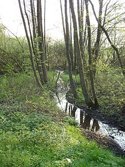
The Ihle in the Obere Ihleniederung nature reserve |
||
The Ihle is a right tributary of the Lesum in the area of the municipality of Ritterhude ( district of Osterholz , Lower Saxony ) and the Bremen district of Burglesum (district of Bremen-Nord).
The 4 km long brook has its source in the Obere Ihleniederung nature reserve . It crosses this nature reserve in an east-west direction, flows in a south-westerly direction through Ihlpohl and passes under the A 27 and A 270 . In the Bremen area, the Ihle first flows through the Burgdamm district in a narrow valley, the base of which is about 10 m below the level of the flanking areas, then in the border area to the Lesum district and finally through the Lesum district to the confluence with the Lesum. The Geestbach flows on several stretches in underground pipes and has other stretches far removed from nature. In Bremen it is classified in the water quality class II-III, in the middle course II.
The Graben im Moor is a small right tributary of the Ihle from the Ruschdahlmoor , a 4.8 hectare nature reserve in Lesum, which borders Ihlpohl in the northeast.
Web links
- Experience nature in Lower Saxony. Map of Lower Saxony, district of Osterholz
Individual evidence
- ^ Surface waters, reports. Umwelt.bremen.de, accessed on November 3, 2012 .

