Teufelsmoor (location)
|
Teufelsmoor
City of Osterholz-Scharmbeck
|
|
|---|---|
| Coordinates: 53 ° 15 ′ 55 ″ N , 8 ° 54 ′ 13 ″ E | |
| Height : | 2 m above sea level NHN |
| Incorporation : | March 1, 1974 |
| Postal code : | 27711 |
| Primaries : | 04791, 04796 |
|
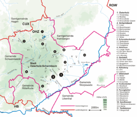
Location of Teufelsmoor in the town of Osterholz-Scharmbeck
|
|
Teufelsmoor is a district of the town of Osterholz-Scharmbeck in the Osterholz district in Lower Saxony .
location
The place is located on the southwestern edge of the Teufelsmoors , a landscape in Lower Saxony north of Bremen , which takes up a large part of the Osterholz district. It lies between the Hamme , a right source river of the Lesum , and the Beek , which in turn is a right tributary of the Hamme.
history
On March 1, 1974, the Teufelsmoor community was incorporated into the district town of Osterholz-Scharmbeck.
Nature reserve
Between Worpswede and the village Teufelsmoor the 203.0 is hectare large nature reserve Broad water . The 196 hectare nature reserve Torfkanal and Randmoore lies in the western area of the village Teufelsmoor.
literature
- Wilhelm Berger: The place Teufelsmoor at the time of the Thirty Years War. Settlement and population structure. In: Heimat-Rundblick. History, culture, nature . No. 106, 3/2013 ( autumn 2013 ). Druckerpresse-Verlag , ISSN 2191-4257 , pp. 20-23.
- Franz-Christian Lenz: The "Villa" in Teufelsmoor. In: Heimat-Rundblick. History, culture, nature. No. 102, 3/2012 ( autumn 2012 ). Druckerpresse-Verlag, ISSN 2191-4257 , pp. 4-5.
Web links
Commons : Teufelsmoor - Collection of images
Individual evidence
- ^ Federal Statistical Office (ed.): Historical municipality directory for the Federal Republic of Germany. Name, border and key number changes in municipalities, counties and administrative districts from May 27, 1970 to December 31, 1982 . W. Kohlhammer, Stuttgart / Mainz 1983, ISBN 3-17-003263-1 , p. 244 .


