
Reddingen
|
Reddingen
Municipality Wietzendorf
Coordinates: 52 ° 54 ′ 41 ″ N , 10 ° 0 ′ 52 ″ E
|
|
|---|---|
| Height : | 72 m above sea level NHN |
| Residents : | 101 (Aug 1, 2020) |
| Incorporation : | March 1, 1974 |
| Postal code : | 29649 |
| Area code : | 05196 |
.jpg)
Reddingen is a district of the Lower Saxon community Wietzendorf in the Heidekreis district in Germany .
The place has only 94 inhabitants with the associated hamlets Reiningen and Halmern.
location
Reddingen is located in the Lüneburg Heath . The Wietze flows through the Reiningen settlement . The Munster Süd military training area begins immediately to the north of the three locations and is usually closed to the public. On most weekends, the Munster-Süd square can also be entered or used by private individuals on specially marked trails.
history
On March 1, 1974, Reddingen was incorporated into the Wietzendorf community.
traffic
The district roads 11 and 38 meet in the village. The 352 bus of the Verkehrsgemeinschaft Nordost-Niedersachsen (VNN) runs through the three villages .
Others
- At the Wietze in Reiningen there is a water level and a hydrological measuring point of the NLWKN for the collection of environmental data.
- In Halmern, Reddingen and Reiningen there are no street names, only house numbers that residents, postmen, suppliers and visitors have to orientate themselves by.
- The mayor is Uwe Hellberg. (As of 2015)
gallery

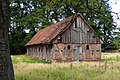
Farm in Halmern

Thatched. House in Reiningen
former pigsty in Reiningen

Historic clay oven in Reiningen

Old stair store in Reiningen
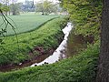
The Wietze between Halmern and Reddingen
.JPG)
.jpg)


.jpg)

Individual evidence
- ↑ http://wietzendorf.de/allgemeine-informationen/70-einwohnerzahl?highlight=WyJlaW53b2huZXJ6YWhsIl0=
- ^ Federal Statistical Office (ed.): Historical municipality directory for the Federal Republic of Germany. Name, border and key number changes in municipalities, counties and administrative districts from May 27, 1970 to December 31, 1982 . W. Kohlhammer GmbH, Stuttgart and Mainz 1983, ISBN 3-17-003263-1 , p. 235 .
