Wolthausen
|
Wolthausen
Winsen (Aller) municipality
Coordinates: 52 ° 41 ′ 39 ″ N , 9 ° 58 ′ 48 ″ E
|
|
|---|---|
| Height : | 39 m |
| Incorporation : | 1st February 1971 |
| Postal code : | 29308 |
| Area code : | 05143 |

Wolthausen is a district of the municipality of Winsen (Aller) in the Lower Saxony district of Celle , which is located on the Örtze and was previously decisively shaped by this river.
history
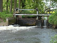
From the 16th century to 1960, the Örtze drove the water wheel of a grain mill here . Today a turbine with a generator runs next to the water wheel to generate electricity . A fish ladder that bypasses this weir, with eight steps, around 1 m wide and around 24 m long, also suitable for invertebrate reptiles , was completed in August 2012.
To regulate the Örtze water , to prevent the flooding of meadows and pastures, a weir with a total clearance of 4.88 m was built in 1872 immediately south of Wolthusen . A flood canal with a length of 2160 m bridges a river length of around 6500 m. The area affected by the regulation covers around 108 hectares. Two canal bridges opened up the meadows and pastures behind the canal. On May 15, 1896, the "Free Örtze Canal Cooperative" was founded with headquarters in Wolthausen. In 1963 it was decided to stop irrigation. The dilapidated weir was repaired again in 1964. The cooperative was dissolved in 1974.
The place is crossed by the federal highway 3 .
On February 1, 1971, Wolthausen was incorporated into the municipality of Winsen (Aller).
politics
The village of Wolthausen has a joint local council with the neighboring village of Stedden .
The local mayor is Christian Peters (CDU).
Architectural monuments
Individual evidence
- ^ Federal Statistical Office (ed.): Historical municipality directory for the Federal Republic of Germany. Name, border and key number changes in municipalities, counties and administrative districts from May 27, 1970 to December 31, 1982 . W. Kohlhammer GmbH, Stuttgart and Mainz 1983, ISBN 3-17-003263-1 , p. 223 .

