
Ban nets
|
Ban nets
Winsen (Aller) municipality
Coordinates: 52 ° 40 ′ 49 ″ N , 9 ° 48 ′ 33 ″ E
|
|
|---|---|
| Height : | 33 m |
| Incorporation : | 1st February 1971 |
| Postal code : | 29308 |
| Area code : | 05146 |
Bannetze is a district of the municipality of Winsen (Aller) in the Lower Saxony district of Celle , which lies on the Aller . The place is crossed by the L 180.
history
The place was first mentioned in documents in 1337. The field name researchers Paul Alpers and Friedrich Barenscheer derive the first name Benetze in this way: "Bennedeshuse, from the personal name Benneid".
On February 1, 1971, Bannetze was incorporated into the municipality of Winsen (Aller).
politics
The village of Bannetze has a joint local council with the neighboring village of Thören .
The local mayor is Heinrich Leymers ( CDU ) from Thören.
Culture and sights
- The Allerwehr Bannetze is the second barrage of the Aller below Celle and was built between 1909 and 1912. The old weir was replaced by a modern inflatable weir after almost 100 years . The weir includes a lock system and a fish pass .
- The school house in Bannetze is a free-standing two-storey school house with an annex, of which a preliminary draft was published in 1910. The construction was carried out in 1911 by Otto Haesler .
Architectural monuments
Architectural monuments in ban nets
Green spaces and recreation
North of the village is the 815 ha large nature reserve and bird sanctuary Meißendorf Lakes with the Bannetzer Moor , the species-rich because of its breeding bird world and as a resting place for migratory birds of national importance.
To the east of Bannetze, on the opposite bank of the Aller, lies the “ Hornbosteler Hutweide ” nature reserve , an area of 176 hectares that was placed under protection in 2004. Here you can still find well-preserved remains of the typical hat landscape . Heck cattle and, since 2009, Przewalski horses too, graze this part of the Allerniederung.

Memorial stone

Old school by architect Otto Haesler

lock

All against
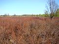
Bannetzer Moor
_IMG_6573.jpg)
_IMG_6585.jpg)
_IMG_6605.jpg)
_IMG_6632.jpg)

Web links
Individual evidence
- ↑ Document 140 of 1337, Wilhelm von Hodenberg : Lüneburger Urkundenbuch, 15th section: Archives of the St. Johannis Monastery in Walsrode , Capaun-Karlowa'sche Buchhandlung, Celle 1859, p. 333; Paul Alpers and Friedrich Barenscheer: Celler Flurnamenbuch: The field names of the city and the district of Celle , Sendet, Erfurt 1952, p. 19.
- ^ Federal Statistical Office (ed.): Historical municipality directory for the Federal Republic of Germany. Name, border and key number changes in municipalities, counties and administrative districts from May 27, 1970 to December 31, 1982 . W. Kohlhammer GmbH, Stuttgart and Mainz 1983, ISBN 3-17-003263-1 , p. 223 .
- ↑ Information from the Federal Waterways and Shipping Administration . In a contract in 1908, the state took over the expansion of the Oldau, Bannetze, Marklendorf and Hademstorf barrages, while the city of Celle leased the use of the water power at the Oldau and Marklendorf barrages. Deutsche Bauzeitung, Verlag Ernst Toeche, Berlin 1908, p. 121: "... which strives for a water depth of 1.5 m at mean low water and for this purpose provides for four barrages at Oldau, Bannetze, Buchholz and Hademstorf ..."
- ↑ Simone Oelker: Otto Haesler - An Architect's Career in the Weimar Republic , 1st edition, Dölling and Galitz Verlag, Hamburg, Munich 2002, p. 274. See Casimir Hermann Baer: Moderne Bauformen, monthly books for architecture and spatial art , Stuttgart 1920 , P. 70.
- ↑ NLWKN: NSG Meißendorfer Teiche / Bannetzer Moor with overview map .
- ↑ NLWKN: NSG Hornbosteler Hutweide .
Ban networks | Meißendorf | Stedden | Südwinsen | Fools | Walle | Winsen (Aller) | Wolthausen