
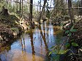
Weesener Bach
|
Weesen Bach Lutterbach |
||
 Pond at the source of the Weesener Bach |
||
| Data | ||
| location | Lower Saxony , Germany | |
| River system | Weser | |
| Drain over | Örtze → Aller → Weser → North Sea | |
| source | south of Lutterloh 52 ° 49 ′ 1 ″ N , 10 ° 12 ′ 46 ″ E |
|
| Source height | 80 m above sea level NHN | |
| muzzle | in the north of Hermannsburg Coordinates: 52 ° 50 '31 " N , 10 ° 5' 47" E 52 ° 50 '31 " N , 10 ° 5' 47" E |
|
| Mouth height | 51 m above sea level NHN | |
| Height difference | 29 m | |
| Bottom slope | 2.1 ‰ | |
| length | 13.7 km | |
| Communities | Lutterloh , Weesen , Hermannsburg | |
The Weesener Bach , also Lutter or Lutterbach (clean = louder = pure = Lutter), is a left, eastern tributary of the Örtze . It is under protection along its entire length. The nature reserve with the sign NSG LÜ 248 is about 348 hectares . The Weesener Bach has essential characteristics of a summer cold, oxygen-rich, nutrient-poor and fast-flowing heather brook. In large parts it still has a natural course. The water quality is good to very good.
Source and history
The Weesener Bach rises in the Südheide Nature Park , south of the village of Lutterloh ( municipality of Südheide ), then flows through Weesen , a village belonging to the municipality of Südheide , and flows into the Örtze after 13.7 km in the north of Hermannsburg .
The Weesener Bach originally had its source in a moor area. To drain the areas behind it, it was lengthened by a ditch. The former moor area was largely converted into a pond area. The ponds are overgrown with pond horsetail over large areas . The entire course of the stream with its edge area, a total of 348 hectares, was placed under nature protection in 1999 . Decisive for this were the still preserved stretches of water with their alder forests, willow trees and the reeds, as well as the springy and muddy valley lowlands with their broken and swamp forest remains. The meadows and pastures that were still intensively cultivated on the edge of the stream were taken out of use. As a result, a near-natural Heidebach has been preserved, the water quality of which has the highest quality classes I-II “lightly polluted” (oligo- to betamesosaprob), with the exception of the upper reaches where the spring ponds are located.
.jpg)
history
In 1892, as part of the Uelzen – Celle field railway exercise, a railway line with a length of around 70 km was built for a narrow-gauge railway from Uelzen via Weesen to Celle . The purpose of the exercise was to find out how, in the event of war, material could be transported to the front on a narrow-gauge railway as quickly as possible. This route was chosen because there were few obstacles and the heath area was isolated. On the occasion of this exercise, a wooden bridge was built between Hermannsburg and Weesen over the Weesener Bach.
Flora and fauna
Due to the high water quality you can find a variety of rare creatures here. Brown trout , bullheads and river lampreys live in the brook . In 1987, 176 animal species were counted here, 36 of which are on the Red List . Another 60 threatened species such as vascular plants , moss species , amphibians and reptiles can be found in the bank area or in the Bachaue . The kingfisher can also be found here.
Water maintenance
According to the Lower Saxony Water Act, the maintenance association Örtze is responsible for the water maintenance of the Weesener Bach. The entertainment association used crawler excavators in the 1970s , which deepened the creek and caused enormous ecological damage to the water, which continues to this day. The firm and gravelly bed of the brook was destroyed and an enormous sand drift started moving from Lutterloh to Hermannsburg. Even large sand traps in the “Sunder” area could not stop these sand movements. In the sandy subsoil, invertebrates , which are the main food of the brown trout, cannot survive. In addition, the trout cannot reproduce because the spawn can only develop on gravelly ground. If it is covered in sand, the larvae suffocate.
Citizens and associations (including the “Bürgerinitiative Südheide”) saw this development with concern. The Weesen councilor Peter Buttgereit was a member of the association assembly of the entertainment association as part of his local political activities and, after years of tough struggle, managed to dispense with the mechanical evacuation. Large sections of the creek have been hand-maintained since 1984. In particular, the specially founded association “Naturschutzfreunde Weesen eV” carries out this work every autumn.
Structural improvement through the introduction of gravel

In the mid-1970s, the bed of the Weesener Bach was lowered. In the process, the pebble-rocky bed structure typical of heather brooks, which represents a special ecological habitat, the so-called hyporheic interstitial , was destroyed. The result was a mostly monotonous sand sole, in which the living beings ( benthos ) found on the bottom zone of a body of water had little chance of survival. For some fish species, so-called gravel spawners such as the brown trout , gravel serves as a spawning area. The eggs and fry develop in the spaces in between. Their numbers also fell sharply. To solve this problem, around 400 tons of autochthonous (local) gravel were brought in for the first time in 2006 . In 2011 a further 1400 tons were built into the stream. In August 2015, to improve the structure of the upper course of the stream, over a length of 1200 meters, another 800 tons of regional, site-specific gravel with a size> = 2 mm Ø were installed. The stones were distributed in such a way that pools , rushes and meanders were created.
The cost of this measure of 60,000 euros was borne by the European Union (from the “European Agricultural Fund for Rural Development”), the Örtze entertainment association and the Celle district .
Luttermühle


A watermill (Luttermühle) with an overshot water wheel is still located near the mouth . The mill had been in operation as a sawmill since 1757 .
In order to conduct the water to the mill, an approx. 1 kilometer long canal was specially dug, with which the watercourse was raised at the same time. A large pond was created right in front of the sawmill . This pond was needed to get more power for the water wheel from the additional water . If the frame saw needed a lot of power, for example to saw large oaks, the additional water was essential. In earlier times the canal was closed once a year, the water was then diverted into the old, original stream bed . Then the washed up and deposited sand was shoveled out of the pond. Because of the enormous amount of work, it was abandoned later. A separate drain was created and from time to time the pond was allowed to drain particularly quickly.
Originally there was also a flour mill and a tannery here . At that time, the water was either used for the sawmill or passed on to the grain mill's water wheel, which was also overshot. As a rule, the sawmill's water wheel was driven during the day and the flour mill wheel at night. Since a fire in 1995, operations have ceased. The sawmill's water wheel has been renewed and sometimes drives an electric generator .
From a nature conservation point of view, the mill is now a major burden for this ecologically very valuable Heidebach. For small fish species and trout, the system represents an obstacle to the expenditure . In order to achieve an exchange between the Örtze and the upper stream, it is imperative to set up a fish path in the old creek bed in the area of the mill . This has so far failed due to the resistance of the landowner.

Source ditch

The Weesener Bach between Lutterloh and Weesen
Canal to the Luttermühle


Web links
- "Weesener Bach" nature reserve in the database of the Lower Saxony State Office for Water Management, Coastal and Nature Conservation (NLWKN)
- Structural improvement of the pool by adding gravel, pdf 6.70 MB
Individual evidence
- ↑ Map services of the Federal Agency for Nature Conservation ( information )
- ↑ Water quality map Weser. Sub-catchment area Aller / Örtze-Nord in the database of the Lower Saxony State Office for Water Management, Coastal and Nature Conservation (NLWKN)


Allerdreckwiesen | Blankes Flath at Jeversen | Broken plank | Bornriethmoor | Fire | Broad moor | Frehmbeck | Goosemoor | Great moor near Becklingen | Heathland middle Lüß plateau | Heath and grassland in the Südheide | Hellern at Wietze | Henneckenmoor near Scheuen | Hochmoore near Wieckenberg | Hoppenriethe | Hornbosteler Hutweide | Kiehnmoor | Laughed | Lünsholz | Lutter | Meißendorfer ponds / Bannetzer Moor | Must | Upper Allerniederung near Celle | Spring and flow moor with small bodies of water near Dalle | Lower Allerniederung near Boye | Broken Pig | Weesener Bach