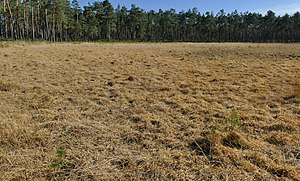
Blank Flath at Jeversen
|
Blank Flath at Jeversen
|
||
| location | West of Wietze | |
| surface | 10 ha | |
| Identifier | NSG LÜ 178 | |
| WDPA ID | 162444 | |
| Geographical location | 52 ° 39 ' N , 9 ° 46' E | |
|
|
||
| Sea level | from 31 m to 34 m | |
| Setup date | 12/28/1989 | |
| administration | NLWKN | |
The Blanke Flath near Jeversen is a nature reserve in the Lower Saxony municipality of Wietze in the district of Celle .
The nature reserve with the sign NSG LÜ 178 is 10 hectares in size. It is located west of Wietze and protects a heather slat with the surrounding area. The Schlatt lies in the dunes that accompany the Allerniederung . Since it dries up in times of low rainfall, there was no bog formation here. When the Schlatt carries water, rushes , peat moss and water hoses grow here . In dry periods, pine trees spread out, which also surround the area. These must then be removed by decussing measures .
The pine forest within the protected area is to be developed into an oak-birch forest corresponding to the natural vegetation .
The area has been a nature reserve since December 28, 1989. The responsible lower nature conservation authority is the district of Celle.


