Fire (nature reserve)
|
fire
|
||
|
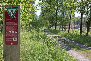
Way into the nature reserve |
||
| location | southwest of Wathlingen | |
| surface | 478 ha | |
| Identifier | NSG HA 105 / LÜ 140 | |
| WDPA ID | 162530 | |
| FFH area | 460.4 ha | |
| Geographical location | 52 ° 32 ' N , 10 ° 6' E | |
|
|
||
| Sea level | from 45.9 m to 58.6 m | |
| Setup date | December 21, 1985 | |
| administration | NLWKN | |
The fire is a nature reserve in the Lower Saxony municipalities of Nienhagen in the joint municipality of Wathlingen in the district of Celle and Uetze in the Hanover region .
The nature reserve with the signs NSG LÜ 140 and NSG HA 105 is 478 hectares . Of this, 471.5 hectares are in the district of Celle and 6.5 hectares in the Hanover region. A 460.4 ha part of the nature reserve forms the FFH area of the same name . A 14 hectare area in the north of the nature reserve has been designated as a natural forest reserve since 1974 . Here the forest is largely left to its own devices. In the south, a small part of borders of the reserve to the conservation area "Reed break". The area has been a nature reserve since December 21, 1985. The responsible lower nature conservation authorities are the district of Celle and the Hanover region.
The “Brand” nature reserve is located southwest of Wathlingen . It places a forest area under protection that grows on loamy floodplain in the floodplain of the Thöse and Aue. Since the expansion of Thöse and Aue, however, the occasional flood has not occurred.
The forest area is characterized by alder , ash and oak stands in the damp areas . Remnants of the old alluvial forest can still be seen here. Oak, hornbeam and red beech trees grow on the higher, drier areas .
The oil works on the edge of the forest area in the west and the former barracks of an ammunition plant in the south are not included in the nature reserve. To the east of the nature reserve is the spoil dump of the former Lower Saxony potash plant. District road 59, which connects Nienhagen with Hänigsen and Ehlershausen , and the route of a former industrial and mine connection railway from the Lehrte – Celle railway in Ehlershausen to the industrial plants and the barracks in Wathlingen and Hänigsen runs through the forest area .
Web links
- Nature reserve "Brand" in the database of the Lower Saxony State Office for Water Management, Coastal and Nature Conservation (NLWKN)
Individual evidence
- ↑ Profile of the natural forest Brand , database natural forest reserves in Germany. Retrieved August 11, 2011.


