
Wathlingen
| coat of arms | Germany map | |
|---|---|---|

|
Coordinates: 52 ° 32 ' N , 10 ° 9' E |
|
| Basic data | ||
| State : | Lower Saxony | |
| County : | Celle | |
| Joint municipality : | Wathlingen | |
| Height : | 43 m above sea level NHN | |
| Area : | 17.68 km 2 | |
| Residents: | 6154 (Dec. 31, 2019) | |
| Population density : | 348 inhabitants per km 2 | |
| Postal code : | 29339 | |
| Area code : | 05144 | |
| License plate : | CE | |
| Community key : | 03 3 51 021 | |
| LOCODE : | DE 75L | |
| Community structure: | 2 districts | |
| Address of the municipal administration: |
Am Schmiedeberg 1 29339 Wathlingen |
|
| Website : | ||
| Mayor : | Torsten Harms ( CDU ) | |
| Location of the community Wathlingen in the district of Celle | ||
  |
||


Wathlingen ( Low German Wateln ) is a municipality in the southeast of the Lower Saxony district of Celle and the administrative seat of the municipality of the same name . It is located around 30 km east of Hanover . Papenhorst is a district of Wathlingen.
geography
The Fuhse flows right past Wathlingen . The community is overshadowed by a potash mountain that is currently around 110 m high. The district town of Celle is about 14 km away.
traffic
Two bus routes operate in Wathlingen .
By CeBus GmbH & Co. KG Wathlingen Spörgenkamp West 19h, from the bus stop connected the village to the district town of Celle: - is every half hour, always. The bus stop is at the beginning of the village and is not far from the two supermarkets ALDI and REWE . Every hour, always at -: 44 o'clock, the CeBus then drives from the bus stop on the Spörgenkamp through all of Wathlingen. The line follows Nienhagener Straße to the LIDL supermarket , where it then turns right behind into Grenzstraße towards the elementary school. After elementary school, the 600 follows Hänigser Straße towards the colony. It leads past the PENNY supermarket, which opened in 2018 . Line 600 then turns into Triftweg after the roundabout. Shortly after you have turned off, the Wathlingen Kolonie bus stop comes. After about one kilometer of the country road, the 600 turns into Uetzer Weg. She follows this to the end and then turns into Schulstrasse. 200 meters after Schulstrasse, the 600 turns into Eicklinger Strasse. This is where the last bus stop in Wathlingen Unter den Eichen comes. Then she drives to Eicklingen , which is also the end point of line 600. The bus stops Wathlingen Unter den Eichen to Wathlingen Heidland are only used every hour.
With the RegioBus Hanover , Wathlingen is served four times a day by bus line 927 with the train station in Ehlershausen. In the morning at 5:42 a.m., 6:39 a.m., and in the evening at 3:47 p.m. and 5:17 p.m. The line starts at the Wathlingen, Schulzentrum bus stop and runs via Papenhorst , Nienhagen and Nienhorst Müggenburg to Ehlershausen. The timetable of line 927 is coordinated with the train departures of the S6 and S7 of the S-Bahn Hanover so that passengers only have to wait a few minutes for their train.
history
The oldest place in the Wathlingen joint community is the seat of the joint community itself. Wathlingen was first mentioned on November 1, 1022, when Bishop Bernward von Hildesheim founded the St. Michaelis monastery in Hildesheim and provided it with several goods, among others. a. “Waditlogon” equipped.

Wathlingen around 1655
.jpg)
The village, which for centuries lived only from agriculture, experienced an enormous change towards an industrial village around 1900 with the construction of the potash plant. The population increased enormously, and today's “colony” emerged as a settlement for miners. The miners' association continues the tradition of the miners today.
In 1997 the Wathlingen community celebrated its 975th birthday.
On July 11th, 2009 the Wathlinger Kickers celebrated their 10th anniversary. Since June 5, 2010 the Kickers have been holding the title "Wathlinger Meister 2010"
The Wathlingen primary school celebrated its 100th anniversary on September 27, 2010. On this occasion, the newly renovated gymnasium of the primary school was handed over to its purpose.
Community partnerships
Religions
The Evangelical Lutheran St. Mary's Church on Kirchstrasse belongs to the Celle parish. The cemetery located within the village also belongs to the parish. The Evangelical Lutheran Kindergarten Marienkäfer, founded in 1960, is located on Kantallee .
A Catholic parish was established in Wathlingen around 1950. In 1960/61, according to plans by Josef Fehlig , the St. Barbara Church was built on the road to Hänigsen ; today it belongs to the parish of St. Ludwig in Celle .
politics
Municipal council
The Wathlingen community council consists of 19 members.
| CDU | SPD | Citizens for Wathlingen (BfW) | Green | FDP | BL | Tuna | left | total | |
| 2001 | 10 | 5 | 2 | 2 | 0 | 19 seats | |||
| 2006 | 9 | 6th | 2 | 1 | 1 | 19 seats | |||
| 2011 | 9 | 6th | 0 | 2 | 1 | 1 | 19 seats | ||
| 2016 | 9 | 5 | 0 | 2 | 1 | 1 | 0 | 1 | 19 seats |
mayor
Mayor since 1824
1824–1831: Hans Heinrich Behrens
1831–1854: Hans Heinrich Timme
1854–1860: Dietrich Ebeling
1860–1878: Hans Homann
1878–1890: Hans Heinrich Engelke (“Stummel-Engelke”)
1890–1896: Heinrich Kesselhut
1896 –1908: Hans Heinrich Engelke
1908–1909: Hans Schrader
1909–1918: Hans Heinrich Brandes
1918–1931: Heinrich Meyer
1931–1933: Friedrich Oberheide
1933–1945: Heinrich Kesselhut
1945–1946: Friedrich Oberheide
1946–1948: Richard Rieke
1948 –1952: Ernst Engelke
1952–1956: Heinrich Hage
1956–1961: Karl Bleckmann
1961–1964: Gustav Pfeiffer
1964–1980: Heinz Homann
1980–1996: Hans-Wilhelm v. Talk
Acting mayor since 1996 is Torsten Harms.
coat of arms
Blazon : "on green background with two crossed hanging ears a three-terminal golden Grapen ; a crossed silver miner's teeth (mallet and iron) with golden handles ”.
Town twinning
A partnership with the French city of Villeparisis has existed since 1975 . In addition, a partnership is maintained with the community of Groß Quenstedt in Saxony-Anhalt .
Culture and sights
- The Wathlingen manor came to the von Reden family through the von Lüneburg family in the 20th century .
- Until 1996, potash was mined in the Lower Saxony mine on the southern edge of the municipality . The still existing spoil dump, the potash mountain, is visible from afar.
- To celebrate the 975th anniversary, donations from Wathlingen citizens and companies were made to put a carillon on the old hose tower next to the town hall.
- Also worth seeing is the Evangelical Lutheran Church of St. Mary with a half-timbered tower in Wathlingen. It goes back to a church from the 14th century, but has changed a lot over time. The von Lünburg family had the church rebuilt from 1696 to 1704. Inside there is a winged altar from the 15th century.
The Kleinbahn Wathlingen-Ehlershausen eV association has existed in Wathlingen since 2007. V. (KWE), also called the Kalibahn . He has set himself the task of making the railway lines of the former mine connection railway to the Lower Saxony and Riedel potash plants passable again. One day, trains are to run again on the scenic routes from Ehlershausen (connection to the DB route network ) to Wathlingen and on to Hänigsen .
Historical, industrial and scenic landmarks are connected to one another. The members of the association are intensively involved in clearing the tracks from wild growth , closing a 1000 m long gap in the tracks ( the rails were stolen by metal thieves ) and refurbishing and supplementing their vehicle inventory.

View of the old courtyard
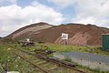
Potash tailings south of Wathlingen
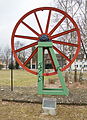
Sheave of the Lower Saxony shaft

Kalibahn in front of the dump

Carillon on the old hose tower


Architectural monuments
Personalities
- Georg von Lüneburg on Uetze and Wathlingen (born November 7, 1735 in Wathlingen; † October 2, 1794 in Wathlingen), electoral stable and court squire 1750, landscape deputy 1765, Drost zu Wittenburg 1772–1776, lord on Uetze and Wathlingen, 1792 after the extinction of those v. Appel with Masendorf at Uelzen belehnt due to the Exspektanz ( Geding ) 1634, 1792 by the Duke Georg Wilhelm to a home fief which v. Dannenberg, v. Weyhe or v. Appel was fixed, and was confirmed in this form by George II in 1745
- Martin Hose (* 1961), classical philologist
literature
- Heinrich Pröve : Wathlingen - history of a Lower Saxon village . Wathlingen 1925/1985.
- Jürgen Gedicke: Wathlingen - History of a Lower Saxon Village, Volume 2 . Wathlingen 1987.
- Matthias Blazek: Wathlingen - History of a Lower Saxon Village, Volume 3 . Wathlingen 2009, ISBN 978-3-00-027770-2 .
- Matthias Blazek: Contributions to the history of the Wathlingen community , issue 1–8. Wathlingen 2005 ff.
Web links
Individual evidence
- ↑ State Office for Statistics Lower Saxony, LSN-Online regional database, Table 12411: Update of the population, as of December 31, 2019 ( help ).
- ↑ "Lots of new discoveries in old writings: history goes back to the High Middle Ages - Wathlingen will soon be a thousand years old / first mentioned on November 1, 1022", Sachsenspiegel 46, Cellesche Zeitung of November 14, 2009.
- ↑ Preliminary results of the district and municipal elections as a PDF document 2.90 MB ( Memento of the original from January 11, 2016 in the Internet Archive ) Info: The archive link was inserted automatically and has not yet been checked. Please check the original and archive link according to the instructions and then remove this notice.
- ↑ Joint community Wathlingen - Parliament. Retrieved November 25, 2019 .
- ↑ List taken from Gedicke (1987), p. 247. There also list of predecessors.
- ↑ Kalibahn.de .
Adelheidsdorf | Ahnsbeck | Beedenbostel | Mountains | Crumble | Celle | Eicklingen | Eldingen | Eschede | Fassberg | Hambühren | Scorn | Lachendorf | Langlingen | Nienhagen | Südheide | Wathlingen | Wienhausen | Wietze | Winsen (Aller)